
Diving Dalgleish Bank

The dive site Dalgleish Bank is an offshore rocky reef, near Knysna in the Western Cape province of South Africa.
Understand
[edit]


Dalgleish Bank is a relatively deep dive site far enough offshore not to be influenced much by inshore conditions, and may have good visibility relatively often for this region. It has a high level of biodiversity and endemicity, and the reef edge dropoffs can be topographically spectacular. The top of the reef extends nearly 2 km east to west, and probably about 600 m north to south, roughly parallel to the coastline.
Position
[edit]A fairly large reef about 11 km offshore of Buffelsbaai, or 15.5 km, (about 8.3 nautical miles) bearing 218°T from Knysna Heads This site is not in a Marine Protected Area. A permit is not required.
Name
[edit]It seems likely that the bank is named after Commodore James Dalgleish, who was a hydrographer and Chief of the South African Navy.
Depth
[edit]Maximum depth is about 80 m off the northwestern wall, and the top of the shallowest part of the reef is about 29 m. Average depth of a dive, excluding decompression, is likely to be about 35 to 40 m, depending on whether you stay on the top or make an excursion down the dropoff.
Visibility
[edit]Visibility can be excellent, as the site is far enough away from the shoreline to not be affected much by the tidal outflow of Knysna lagoon or any of the nearby rivers, but the bank has not been dived enough to predict conditions with any confidence. In December 2021 the visibility was good and the water temperature warm from top to bottom, while in early February 2022, a warm (16°C) turbid (3 to 6 m viz) layer of some 8 to 15 m depth overlaid a much clearer (20 m viz) and colder (8°C) bottom water. In early February 2023 conditions were very similar to the same time in 2022.
Topography
[edit]A fairly flat topped expanse of hard sedimentary rock, with a dropoff around the edge, which is quite sheer in places, and the edges and top surface are cut in places by deep and occasionally narrow gullies. The top surface slopes gradually over much of the area, with occasional near vertical steps up to a few metres high. There are some large boulders and overhangs at the dropoff, and on the bottom nearby.
Geology: Hard sandstones. Dip near horizontal.
Conditions
[edit]
The site is exposed to the weather, wind waves, and swell from all directions, so should be dived when the weather and sea state forecast is good. The conditions at Knysna heads may be a limiting factor, as they must be crossed on the way out and on the way back. A large swell entering the heads against an outgoing tide may be uncomfortable to dangerous, and local knowledge may help. The navigable channel appears to be relatively close to the west side of tne heads, and there are channel marker buoys inside the lagoon all the way to the yacht club and to the island slipway.
Water temperature and clarity may vary with depth. In early February 2022 the surface temperature was 20°C, dropping to about 8°C on the reef top, well below the thermocline, which was somewhere around 8 to 12 m deep. There was a distinct improvement in visibility in the water below the thermocline, and the shallower water was quite turbid and green with what appeared to be an algal bloom, but surprisingly little larger zooplankton. Ascending through the thermocline was like rising into a warm fog, and the turbid upper layer cut off most of the sunlight, leaving the deeper water poorly illuminated. At other times the visibility has been reported to be good from top to bottom, with warm water all the way down.
There may be a current of up to and possibly over 2 kph. This is not necessarily caused by local winds, as it can develop overnight in light wind conditions, and has been measured as flowing east to north-east, from the surface right down to the top of the reef. The deeper areas along the dropoff may be sheltered from the current in places, depending on current direction, and the current speed may vary with depth.
Get in
[edit]This is a boat access dive as it is several kilometers offshore. The site is about 10.8 nautical miles (20 km)from the slipway on Leisure Island and much the same distance from the Knysna yacht club in Knysna lagoon, or about 8.4 nautical miles (15.5 km) from Knysna heads. There are no realistic alternatives for a day boat. In an emergency the harbour at Mossel Bay could be used, but it is 75 km to the west.
Do
[edit]Dive at one of the listed drop points, or explore another area and let us know what you find.
1 Katja's Wall: S34° 11.737', E22° 57.186', Southwestern edge of reef top. 40 m at drop with dropoff to 60 m at the bottom of the wall and 35 m local minimum.
2 West Pinnacle: S34° 11.610', E22° 57.144', Top of the reef, at the west end. 32 to 37 m.
3 South Gully: S34° 11.773', E22° 57.293', Southern edge of the reef top. Depth at drop 42 m. 35 to 45 m. Flattish reef top with some deep gullies and ledges.
4 Stefan's Koppie: S34° 11.603', E22° 57.459', Top of the reef, roughly central. Depth at drop 30 m, Reef depth in vicinity 29 to 32 m. Relatively shallow and mostly fairly flat low profile reef, but good rugosity and high biodiversity. Lots of small Ecklonia radiata (spiny kelp). None of the brown Dalgleish sea fans, maybe too shallow.
5 East Point: S34° 11.541', E22° 58.297', Northern edge of the reef top. Depth at drop 40 m, 38 m deep on flattish top with a steep dropoff to 65 m a short distance away.
6 Josh's Drop: S34° 11.570', E22° 57.178', Top of the reef, northwest end. Depth at drop 34 m, 33 to 35 m.
7 Grant's Wall: S34° 11.630', E22° 58.076', Southeastern edge of the reef top. Depth at drop 40 m, 39 m on top with a dropoff to 55 m.
8 West Wall: S34° 11.674', E22° 56.993', Depth at drop 45 m, bottom of wall 80 m
9 Ben's Beach: S34° 11.733', E22° 57.301', Depth at drop 36 m, bottom of gully 50 m. Medium to high profile sandstone reef, with ridges and gullies.
10 Sam's Drop: S34° 11.606', E22° 57.061', Depth at drop 38 m
11 Johan's Ridge: S34° 11.746', E22° 57.419', Depth near drop about 36 to 40 m
12 Wednesday Drop: S34° 11.577', E22° 57.100', Depth about 36 to 38 m. Moderate profile reef top with small ridges and gullies.
13 Hole-in-the-Wall: S34° 11.408', E22° 58.124', Depth at drop about 37 m near the top of the wall. Zigzag dropoff edge of vertical wall with a few moderate profile gullies in the flattish reef top. Swim-through under a slab boulder at about 50 m below gully near drop point (the Hole in the Wall). Maximum depth near wall probably about 55 m. Lots of yellow zoanthids and yellow soft corals at the edge of the dropoff. Very pretty wall, Top of the reef is also colourful, but not as spectacular as the wall. Surge along the top edge can be strong in a swell. Phyllodesmium sp. nudibranch found here on Dalgleish sea fan on reef top.
See
[edit]
A good site for colourful invertebrates, and when not too cold, abundant reef and pelagic fish.
Marine life
[edit]
Dalgleish Bank is in the middle of the warm temperate inshore Agulhas ecoregion, which extends from Cape Point to the Mbashe River, and is the major marine ecoregion of the south coast. Upwelling on the south coast of South Africa is largely driven by the Agulhas current and the continental shelf. This form of upwelling forces cold deep water up onto the continental shelf, but not necessarily above the thermocline. In the region east of the Agulhas bank, wind enhanced upwelling, occurring mainly in summer, augments the current driven upwelling bringing the colder deeper waters to the surface. This enhances biological productivity by supply of nutrients to the euphotic zone (where plants have sufficient light to flourish) which fuels phytoplankton production, and rocky shores that are supplied with the nutrient rich water support rich algal biomass. This ecoregion is also the centre of endemicity for South African waters, and a relatively high percentage of endemic species can be expected. The reef has not been extensively dived, and it is likely that undiscovered species will be found, particularly among the organisms without a planktonic stage.
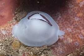
Invertebrates that are relatively common at this site include basket stars, a finely branched orange or brown sea fan, noble corals and other hydrocorals, and in the deeper areas, deewater urchins, a few species of gorgonian and other soft corals, and colonies of yellow zoanthids. Sponges are everywhere. Elegant feather stars are present but sparse. There appear to be quite a variety of white dorid nudibranchs with dark brown or black spots, known to divers as "Dalmatians" which represent several genera and species, some probably undescribed. Also a fair number of the frilled nudibranch Leminda millecra The shallower areas on the top of the reef support a fairly sparse spiny kelp forest, and a fairly diverse but not very dense understorey of small red and brown algae. When the water is warm and clear there may be shoals of pelagic fish like yellowtail and bonito over the bank, or a sunfish may pass by or stop for a while at a cleaning station.
 Basket stars on sea fans
 Sponges and corals
 Deepwater sea urchin
 Noble corals
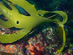 Kelp at Dalgleish bamk
 Reef life at Dalgleish Bank
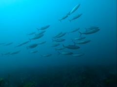 Shoal of Bonito
 Oceanic sunfish
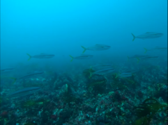 Yellowtail


Gallery under construction: Please discuss before deleting. There will be related text when we get round to it.
- Dominos: Variability of a species of 'Dalmatian nudibranch'
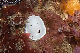 Doris sp.
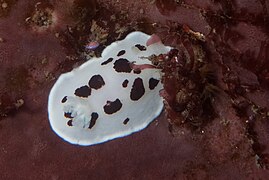 Doris sp.
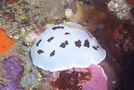 Doris sp.
 Doris sp. mating


- Triviella: Variability of mantle coloration.
 Triviella sp.
 Triviella sp.
 Triviella sp.
 Triviella sp.
 Triviella sp.
 Triviella sp.


- Other nudibranchs etc, including depth range extensions.
 Aphelodoris sp.
 Hypselodoris capensis at 36 m
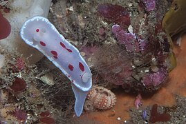 Goniobranchus heatherae at 36 m
 Tritonia sp
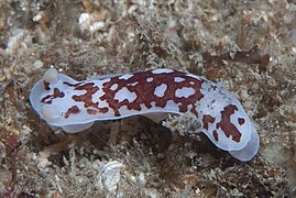 Aphelodoris brunnea
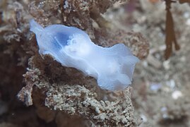 Lecithophorus capensis
 Aplysia sp.
 Pleurobranchaea tarda


Stalked sponges of this kind were previously only known from deeper than 100 m in South Africa, until recently found around Cape Town at 14 to 30 m, and now also at Dalgleish.
- Other stuff: Organisms seen at Dalgleish Bank worth a mention.
 stalked sponge
 deepwater urchin Echinus gilchristi
 Zoantharia sp.
 unknown sea spider
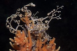 Astrocladus euryale
 Astrocladus euryale
 Dalgleish seafan
 Trichogorgia sp.
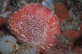 unusual sponge


- Grant's Wall site
 Hydrocoral
 Soft coral
 Hydroids
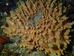 Sponge
 Yellow zoanthids
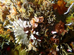 White coral
 Reef life assemblage
 Cup sponges
 Vase sponges
 Hydroids with encrusting ascidian


Features
[edit]
Steep drop-offs around the edges, and some nice wall-sided gullies cutting into the table-top.
Photography
[edit]A great area for macro and close-up wide angle with flash, and in good viz and lighting, will also be good for wide angle scenic shots.
Suggested routes
[edit]If you are equipped for a dive to 50 to 60 m, a dive starting at the top of the drop-off, going down to the local bottom, back up the slope and then spend the rest of the time moving uphill over the top of the reef gives a wide variety of scenery and biodiversity. Some decompression stops will be necessary. Take current speed and direction into account when planning the dive. Surface current may be much stronger than bottom current and you may drift a long way at the decompression stop.
Stay safe
[edit]Hazards
[edit]A fairly strong current may run, making progress upstream difficult for the person towing the surface marker buoy, and any diver separated from the group is at risk of drifting a long way from everyone else during decompression.
Skills
[edit]This is not a dive site for inexperienced divers. Competence to plan and execute a dive below 30 m and to deploy a DSMB are essential. Competence to do planned decompression dives is strongly recommended.
Equipment
[edit]Bottom temperature is variable and may drop as low as 8°C, for which a dry suit is strongly recommended. The dive leader should tow a surface marker buoy to indicate position of the group to the boat, and any divers separated from the dive leader should deploy a DSMB as soon as reasonably practicable, as this is not a place where you want to be lost, and there may be a fairly strong current. Nitrox is recommended to extend bottom time, and trimix is recommended for excursions down the dropoff. For planned decompression, a suitable decompression gas should be carried, and if a decompression trapeze is to be used, it will probably be most convenient for it to be deployed on a signal from the surfacing group if a current is running. There are, as of early 2023, no filling facilities or dive charter boat services in Knysna.
Nearby
[edit]
Other dive sites of the Knysna region:
- 1 Bruces Bank
Back to Diving the south coast of South Africa#Destinations