File:Grimsaywheelhouse.jpg
Jump to navigation
Jump to search
No higher resolution available.
Grimsaywheelhouse.jpg (640 × 480 pixels, file size: 118 KB, MIME type: image/jpeg)
This is a file from the Wikimedia Commons and may be used by other projects. Information from its description page there is shown below.
Commons is a freely licensed media file repository. |
Summary
| Description |
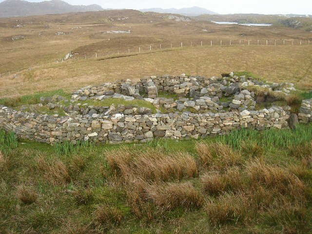
Grimsay Wheelhouse This is possibly the best preserved example of a wheelhouse on North Uist and is not shown on the OS maps. Difficult to find, it is located between Loch Hornary and the north coast of Grimsay. It dates from the Iron Age. Grimsay, Outer Hebrides, Scotland. |
| Date | |
| Source |
This image was taken from the Geograph project collection. See this photograph's page on the Geograph website for the photographer's contact details. The copyright on this image is owned by Bob Jones and is licensed for reuse under the Creative Commons Attribution-ShareAlike 2.0 license. From geograph.org.uk |
| Author | Bob Jones |
| Permission (Reusing this file) |
See below. |
| Attribution (required by the license) | Bob Jones / Grimsay Wheelhouse / |
| Camera location | | View this and other nearby images on: OpenStreetMap |
|---|
| Object location | | View this and other nearby images on: OpenStreetMap |
|---|
_region:GB-GBN_heading:135.00&language=en)
Licensing

|
This image was taken from the Geograph project collection. See this photograph's page on the Geograph website for the photographer's contact details. The copyright on this image is owned by Bob Jones and is licensed for reuse under the Creative Commons Attribution-ShareAlike 2.0 license.
|
This file is licensed under the Creative Commons Attribution-Share Alike 2.0 Generic license.
Attribution: Bob Jones
- You are free:
- to share – to copy, distribute and transmit the work
- to remix – to adapt the work
- Under the following conditions:
- attribution – You must give appropriate credit, provide a link to the license, and indicate if changes were made. You may do so in any reasonable manner, but not in any way that suggests the licensor endorses you or your use.
- share alike – If you remix, transform, or build upon the material, you must distribute your contributions under the same or compatible license as the original.
File history
Click on a date/time to view the file as it appeared at that time.
| Date/Time | Thumbnail | Dimensions | User | Comment | |
|---|---|---|---|---|---|
| current | 17:50, 21 November 2007 | | 640 × 480 (118 KB) | MacRusgail | == Summary == {{Information |Description=Grimsay Wheelhouse This is possibly the best preserved example of a wheelhouse on North Uist and is not shown on the OS maps. Difficult to find, it is located between Loch Hornary and the north coast of Grimsay. It |
File usage
The following page uses this file:
Global file usage
The following other wikis use this file:
- Usage on el.wikipedia.org
- Usage on en.wikipedia.org
- Usage on fa.wikipedia.org
- Usage on fr.wikipedia.org
- Usage on nn.wikipedia.org
- Usage on pl.wikipedia.org
- Usage on pt.wikipedia.org
- Usage on zh.wikipedia.org