File:Pittsburgh TAC.tif
Jump to navigation
Jump to search

Size of this JPG preview of this TIF file: 800 × 514 pixels. Other resolutions: 320 × 206 pixels | 640 × 411 pixels | 1,024 × 658 pixels | 1,280 × 822 pixels | 2,560 × 1,644 pixels | 9,554 × 6,136 pixels.
Original file (9,554 × 6,136 pixels, file size: 17.66 MB, MIME type: image/tiff)
This is a file from the Wikimedia Commons and may be used by other projects. Information from its description page there is shown below.
Commons is a freely licensed media file repository. |
Summary
| Description |
English: VFR terminal area chart (TAC) around PIT/KPIT, a class-B airport. |
| Date | |
| Source | https://www.faa.gov/air_traffic/flight_info/aeronav/digital_products/vfr/ |
| Author | Federal Aviation Administration |
Licensing
This image or file is a work of a Federal Aviation Administration employee, taken or made as part of that person's official duties. As a work of the U.S. federal government, the image is in the public domain in the United States.
|
 |
File history
Click on a date/time to view the file as it appeared at that time.
| Date/Time | Thumbnail | Dimensions | User | Comment | |
|---|---|---|---|---|---|
| current | 13:54, 31 July 2023 | 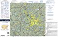 | 9,554 × 6,136 (17.66 MB) | 痛 | Uploaded a work by {{label|Q335357}} from https://www.faa.gov/air_traffic/flight_info/aeronav/digital_products/vfr/ with UploadWizard |
File usage
There are no pages that use this file.
Global file usage
The following other wikis use this file:
- Usage on en.wikipedia.org