Appearance
Point Lookout is the southern-most point of Southern Maryland.
Get in
[edit]Point Lookout is found at the end of Maryland Route 5.
From the Washington, D.C., area, take the Capital Beltway to Exit 7A, Route 5 South. Take it to the end.
From Annapolis, take Route 2 South. At the end, make a left onto Route 4 South. After crossing the Gov. Johnson Bridge, make a left onto Route 235 South. At the end, make a left onto Route 5 South. Take it to the end.
There are ferries between Point Lookout and Smith Island.
Get around
[edit]See
[edit]
- 1 Confederate Memorial Park. Sunrise-sunset. During the Civil War, General George McClellan's Peninsula Campaign failed to capture Richmond, and the Union Army built a hospital at Point Lookout to treat the injured soldiers. After the Battle of Gettysburg, the Union established a prisoner-of-war site at Point Lookout for captured prisoners. During its two-year existence, more than 50,000 prisoners were at the site. Only tents were provided to prisoners for shelter, which were insufficient, and 3,384 prisoners died. The prisoners were originally buried in two cemeteries nearby. In 1870, the state of Maryland moved the bodies to a more favorable site one-mile inland, and the individual graves could not be identified, so the remains were buried in a common grave. An 80-foot-tall granite monument was built at the gravesite, with the known names of the people buried at the site. There is a marble monument as well.
- 2 Civil War Museum, Lanier Loop, Scotland. May-Oct: Sa Su 9AM-5PM. A museum about Point Lookout's history as a prisoner-of-war camp for captured Confederate soldiers and civilians.
- 3 Fort Lincoln. Fort Lincoln was one of three forts built to defend Point Lookout during the Civil War. It is the only surviving structure from the Civil War at Point Lookout. Fort Lincoln is a four-sided earthen fort with cannon platforms, a powder magazine, and a sally port entrance. The fort itself is original, but the four buildings inside the fort are reconstructions based on military blueprints.
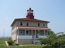
- 4 Point Lookout Lighthouse, ☏ +1 301 872 5688. Lighthouse at the tip of the peninsula, built in 1830.
Do
[edit]- 1 Boat Launch Ramp. $10.
- 2 Fishing Pier. Open mid-Apr through the third week in Dec. A 710-foot-long fishing pier. A valid Coastal Sport Fishing license and appropriate stamps are required for those age 16 and older.
- 3 Swimming Beach, ☏ +1 301 872 5688. 6AM-sunset (weekends and holidays, May-Sep), 7AM-sunset (weekdays, May-Sep), 8AM-sunset (Oct-Apr). Sandy beach for public swimming. Showers and restrooms are available.
Buy
[edit]- 1 Park Store. May-Sep. The park store sells snacks, ice cream, drinks, bait, ice, souvenirs, and supplies for boating, picnicking, and camping. Canoe rentals are available.
Eat
[edit]- 1 Buzzy's Country Store, 12665 Point Lookout Rd, Ridge, ☏ +1 301 994 0826. Tu-Th 12:30PM-9PM, F 11AM-9PM, Sa 10AM-9PM, Su 9AM-9PM, closed M. Food and drinks
- 2 Ridge Market, 13270 Point Lookout Rd, Ridge, ☏ +1 301 872 5121. Su-F 8AM-9PM, Sa 8AM-10PM. Food to go.
Drink
[edit]Sleep
[edit]- 1 Point Lookout State Park Camping and Cabins, ☏ +1 888 432 2267. Check-in: campsites 10PM, cabins 3PM, check-out: noon. 143 wooded campsites, including 26 with full hook-ups, 33 with electric, and 1 for youth groups. Also has 5 four-person camper cabins for overnight stays. There are fire rings for cooking. Pets, smoking, and cooking are not allowed inside the cabins.


