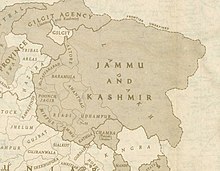
Poonch jagir is a former administrative division of the princely state of Kashmir. It was divided between India and Pakistan in 1947 and now consists of five districts: one in India and four in Pakistan. The government of India claims the entire region as "Poonch district". However, this article does not endorse claims by either side in the dispute.
Districts
[edit]| Jammu and Kashmir (Poonch district) Administered by India. |
| Azad Kashmir (Bagh district, Haveli district, Poonch district, Sudhanoti district) Administered by Pakistan. |
Towns
[edit]Other destinations
[edit]Understand
[edit]In ancient times, Poonch jagir was part of the Abhisara region and formed part of Alexander the Great's conquests. In later sources, the region is called Paranotsa, but also known by its capital city, Lohara, which gave rise to the Lohara dynasty of Kashmir. Afterwards Poonch came under the control of the Mughal Empire, then the Durrani Empire and finally the Sikh Empire. The Sikh monarch, Maharaja Ranjit Singh gave Poonch to the Dogra noble, Raja Dhyan Singh, as a fief. After the death of Ranjit Singh, Dhyan Singh was murdered in Sikh intrigues, and the region was transferred to Gulab Singh as part of the princely state of Kashmir under the British Raj. After the dissolution of the British Raj in August 1947, a war between India and Pakistan took place. The war ended a year later with the region being divided between India and Pakistan by a "ceasefire line" declared by the United Nations, later known as the Line of Control (LoC).
Get in
[edit]Aerial options to get in the region is limited, with Poonch Airport is the only operational "heliport" in the region. There is an airport in Rawalakot, but that is closed. While road is the most dominated option to get in the region, travelling by road to the region is itself an attraction as you come across the most beautiful scenes of winding rivers and hills.
Stay safe
[edit]Certain areas of the region are off-limits to tourists, particularly the 15-mile-wide (16 km) buffer zone along the Line of Control that separates Azad Kashmir from Jammu and Kashmir. Do not take photos of the military structures along the buffer zone or else you will be in a serious danger.

