

The dive site Rapid Bay Jetty or just Rapid Bay is a shoreline site associated with a pair of jetties at the town of Rapid Bay on the Fleurieu Peninsula in South Australia.
Understand
[edit]


Rapid Bay Jetty is a popular dive site because of its ease of access, relatively shallow depth, protection from prevailing weather for most directions and the presence of a large variety of fish including iconic species such as the leafy seadragon. The site is highly regarded as a venue for underwater photography.
The site is a popular venue for service providers of leafy seadragon tours.
Position
[edit]S 35°31.278', E 138°11.121'
The pair of jetties is located at the west side of Rapid Bay which itself faces north. The two jetties which have the same north-south alignment, are spaced about 50 m apart.
The jetty on the east side is a new structure opened in 2009 to provide a platform for recreational fishing and an access point for recreational divers following the progressive closure of the old jetty prior to 2008. It extends out to sea for a distance of 240 m and has a dedicated entry point for divers consisting of stairs and an entry platform complete with ladder at its end. This jetty is known as the Rapid Bay Jetty or just simply as “the new jetty”.
The jetty on the west side which is known as the Old Rapid Bay Jetty (or the “old jetty”) was opened in 1942 to support a conveyor system for loading ships with crushed limestone sourced from the quarry that occupies much of the bay’s west side. It extends out to sea for a distance of about 450 m to a wharf area which is parallel to the shoreline and which has an overall length of about 200 m. The wharf consists of six dolphins (three on each side of the jetty) all connected by walkways. The dolphins are clusters of closely spaced piles which serve as points to tie up ships. The junction of the wharf and the jetty is known to divers as the ‘Tee’. The old jetty is closed to public access - a measure made permanent by the partial demolition of its length near the shore.
This site is within a marine protected area, the Encounter Marine Park, but it is not subject to any controls apart from fisheries regulations in respect to the collection of marine life.
Name
[edit]The name "Rapid Bay Jetty" is derived from the name of the old jetty which has been a venue for diving since the 1950s. Despite the presence of two jetties, the site is usually discussed in the singular as the objective of most diving at this site is to visit to the old jetty. It is also known as just "Rapid Bay".
Depth
[edit]Maximum depth at the end of the old jetty is between 10 and 12 m at high tide while an average depth at the end of the old jetty Including the dolphins) will probably be in the range of 8 to 9 m. Depth at the old jetty opposite the entry staircase on the new jetty is usually in the range of 5 to 6 m.
Maximum depth at end of the new jetty is about 5 m at low tide.
Topography
[edit]The old jetty extends in a northerly direction from the shore for about 360 m. The seabed which is sand falls from about 1 m to about 5 m immediately opposite the entry point on the new jetty and remains relatively flat until the 360 m point. The seabed between the piles is covered with a range of materials including some of the concrete casings that were added to the timber piles during the late 1930s to protect against teredo worm attack, limestone gravel that fell from the conveyor belt and the remains of timber piles that fallen away from the main structure after teredo worm attack and subsequent rotting as well as the occasional bare patch of sand.
At about 360 m from the shore, the sea bed abruptly falls from about 5 m to a depth of 8 m. This is the point where the old jetty turns slightly to the right hand and where its structure changes from concrete-encased timber piles at 5 m spacings to steel piles at 8 m spacings. The jetty extends another 80 m until it reaches its end.
The dolphins which each occupy a footprint of about 10 m by 10 m are surrounded by a meadow of seagrass to their south, east and west sides and by a meadow dominated by brown algae plants to their north. Seabed around the dolphins and the end of the jetty is also littered with a range of materials. In particular, the dolphin immediately east of the 'Tee' has an assemblage of structure (known as the ‘A frame’) on its south side and a large fender (i.e. about 9 m wide by about 8 m height) laying face down on the seabed (known as ‘the grid’) on its north side.
The new jetty extends from the shore for about 240 m. The seabed under the jetty is a relatively flat surface of sand covered in varying degrees by seagrass.
Conditions
[edit]The site is exposed to weather and associated sea conditions in the sector extending from the north-west to the north-east, however it can be dived in these conditions if these are mild enough not to affect access in and out of the water and the underwater visibility. As a guide, viz less than the spacing of the piles on the old jetty (i.e. 5 m) is unsatisfactory from a navigational perspective.
The site is reasonably protected from weather blowing from the sector between the south-west and the north-west, however winds from this sector can create swelly conditions within Rapid Bay resulting in reduced visibility.
The site is usually at its best during the months of January to April when the prevailing wind pattern is blowing offshore, i.e. from the south-east, but there are also opportunities at other times of the year when the wind patterns are blowing from the sector between the north-east and the south-west.
There may be slight tidal currents, which do not necessarily run in the direction you might expect - a slight westward drift has been known on a rising tide with no wind.
Weather observations specific to the locality, particularly wind direction and speeds, are available online from the automatic weather station located at Parawa West which is located about 10 km to the south east of Rapid Bay.
Facilities
[edit] Seaweeds on piling with Dusky morwong
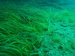 Seagrass at Rapid Bay Jetty
 Sessile organisms on piling


Parking: Vehicles can be parked as close as 60 m to the new jetty, but the parking area is long and narrow.
Ablutions: A public toilet provided by the District Council of Yankalilla is located on Essington Lewis Drive opposite the camping ground about 650 metres east of the new jetty.
Camping ground: A basic facility[dead link] provided by the District Council of Yankalilla is located on Essington Lewis Drive opposite the public toilet about 650 metres east of the new jetty. It consists of unpowered sites supported by coin-operated electric barbeques, children’s playground and some shelter structures complete with tables and benches.
Pay phone: a pay phone[dead link] is located on Essington Lewis Drive just outside the camping ground and opposite the public toilet.
Nourishment: Food, coffee and other refreshments can be purchased from the general store on the Main South Road at Delamere about 7 km away, i.e. turn right at the Main South Road. Other outlets are available at both Normanville (about 25 km to the north via the Main South Road) and Yankalilla (about 28 km to the north via the Main South Road).
Air fills: as the nearest filling station is in the central Adelaide metropolitan area about 95 km away, it is a good idea to bring enough cylinders for the planned diving activity as well as any diving spares.
Get in
[edit][add listing]
Access is normally by a large, sturdy steel staircase with a landing at the bottom, which is at about low-tide level, and has convenient handrails. This staircase is at the outer end of the new jetty, which is a concrete structure in good condition, with a fairly smooth surface, suitable for a handcart to carry heavy dive gear from the parking lot to the entry point.
Access is also possible from the shore between the two jetties. However, the approach is relatively steep and it is necessary to walk in shallow water over a “loose” and “wobbly" bottom consisting of boulders about the size of a football in order to move between dry land and diveable water. It is a lot less effort to walk along the new jetty than to swim the extra distance to get to the most popular areas to dive.
The site is also accessible via boat either by using the services of a boat dive charter operator or going with divers who own boats.
See
[edit][add listing]Marine life
[edit][add listing]The piles of the old jetty are well covered with sponges, ascidians and seaweeds. The bottom has patches of gravel with scallops, sand with seagrass and rubble with seaweed and sessile invertebrates. Fish tend to cluster under the shady intersection of the Tee in the part known as the Cathedral more than along the more open areas of the jetty.
 Leafy sea dragon Phycodurus eques
 Crab Leptomithrax gaimardii
 Scallop Equichlamys bifrons under the old jetty
 Hermit crab
 Cuttlefish Sepia apama
 Shoal of fish under the old jetty
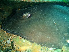 Urolophus sp. stingray lurking under some debris
 Bobtail squid Euprymna tasmanica
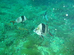 Magpie perch Cheilodctylus nigripes
 Wavy volute Amoria undulata


Photography
[edit][add listing]Plenty of good subjects for macro and close-up work, and good views for wide-angle. If the viz is good, it should be possible to get good fish portraits too.
Suggested routes
[edit][add listing]Most dives are under the old jetty. Enter at the staircase on the new jetty, swim across to the old jetty, and dive anywhere that suits your skills and fitness. The jetty provides very good landmarks so it is easy to know where you are.
Stay safe
[edit]Hazards
[edit]Large site: the relatively large size of the site and the relative uniformity of the appearance of many of the elements of the old jetty creates a potential for disorientation. Also, when diving from the new jetty or the shore on the south side of the site, relatively long swimming distances may occur as the result of a desire to visit particular parts of the site. Accordingly, measures to avoid getting lost and running out of gas need to be considered.
Boats: there is regular boat traffic around the old jetty and which is associated with either diving or recreational fishing activity.
Collapsing jetty structure: the old jetty is undergoing a gradual process of collapse and it is not unusual to see some evidence of collapse in the section immediately adjoining the new jetty. It is a good idea to do a visual check of the old jetty before entering the water. If you have any immediate concerns about the structural stability of any part of the old jetty or wish to report any damage to the new jetty, please contact the Department of Transport Planning & Infrastructure which is the SA Government agency responsible for infrastructure such as jetties at the following number: 1800 018 313 (i.e. the number for reporting jetty damage, navigation or beacon faults). If diving from a boat, it is wise not to moor the boat next to or under any part of the old jetty.
Altitude: the height above sea level at the turnoff to Rapid Bay on the Main South Road is about 225 m while the altitude of the road will rise above 300 m if one continues in a southerly direction to Cape Jervis or to Victor Harbor via this route. This may increase the risk of acquiring Decompression Illness (DCI). If any symptoms of DCI appear during or after an ascent to attitude, it is wise to contact DES for advice.
Rural location: the site’s location within a rural area means that access to and from it may be subject to bush fires for the period between the months November to April.
Skills
[edit]Entry level site, however skills associated with both dive planning, i.e. picking the best tides and to interpret weather forecasts, and underwater navigation are useful.
Equipment
[edit]No special equipment is required. However, a compass can be useful for finding the way back to the shore, i.e. swim south. A torch is useful during daylight hours to illuminate the invertebrate animal life under the shade of the old jetty's deck to reveal the actual colours. If you have a camera, take this along. A ground sheet is useful for setting up equipment in the car park in order to keep equipment clean and dry as the car park surface is unsealed. A handcart allows you to easily carry heavy gear along the new jetty to the stars.
Back to Diving in South Australia#Fleurieu Peninsula