
Culturally significant landscapes in Almería

The Route of the Landscapes of Cultural Interest in Almería is a cultural route that runs through various cultural landscapes of the province of Almería that, due to their socio-cultural, natural and geographical values, are of special interest. The original reference documentation is available on the website of the Digital Guide to the Cultural Heritage of Andalusia.
Understand
[edit]| “ |
…This is a land with a soul, |
” |
—FERNÁNDEZ REVUELTA, José, Fragment from the poem Burning Threshold. Almería. (1973) | ||

This route through the province of Almería proposes a journey along a selection of landscapes included in the Registry of Landscapes of Cultural Interest in Andalusia. Of the 117 landscapes in the register, 12 are in the province of Almería and, according to the categories that they have been classified in, are representative of its settlement system (3), obtaining and processing resources (7), security and defence (1), and the ideological and associative systems (1). Each has its own particular technical data sheet that condenses and analyses the information that has been collected. These documents can be used as an aid and, as they are referred to on the proposed route to help with the interpretation and enjoyment of the natural and cultural values of the Almerian landscapes.

In this territory, a large part of the land is so dry that it is the victim of encroaching desertification, and this, and its remoteness from large economic centres, are what have to a great extent determined the ways of life and Najjar distribution of a population that has traditionally been widely scattered to take advantage of the province’s limited resources. The mark that humans have left in its landscapes can be traced back to very remote times: places where archaeological sites bear witness to prehistoric settlements dating from the first and second millennia; to post Al Andalus era settlers who colonised uninhabited areas where people still live today, such as many of the small mountain villages, and the strategic defensive positions to maintain control over the territory and guard the mediaeval borders along the Moorish Strip and the coast. Mining has left a semblance in the landscapes of today of the miners of the past who excavated mountains for little return and the remains of the buildings constructed by the companies whose opportunism led to the area being abandoned once it had been stripped of its ore. Traditional agriculture spread around the river basins in a great system that uses water in narrow strips of mountainside land, terraces, channels, wells, underground cisterns and water wheels and mills, etc., stands in contrast to the more recent intensive agriculture in the south of the province near the capital, designed for export and amassed in the greenhouses that are the real engines of the economy today. These new circumstances have not only sparked the population’s further relocation to points on the coast, although this had already begun when the tourist industry began to benefit from the excellent weather conditions around 1970, but has also attracted a workforce from abroad that has become a powerful factor for change in the shaping of the new social reality.
A province-wide journey along this route can begin out from the capital on the southern coast northwards to the prehistoric landscape of Los Millares. From here, you can go west along the valley of the Andarax river to the vine-covered landscape of Ohanes. From this furthermost eastern point of the Sierra Nevada, go back as far as the sprawling Tabernas Desert, where you will be able to set your eyes on the natural scenery and the internationally recreated infrastructure fashioned by Spanish and other foreign film-makers where spaghetti westerns were shot. From here you carry on up the Los Filabres Mountains until you reach the villages of Tahal, Alcudia de Monteagud and Chercos, where the houses are dotted along the mountainsides and conserve the landscape of mediaeval settlements in the Moorish tradition. Follow on to the northernmost point of the province to observe the landscape of Vélez-Blanco, where the defence of the territory prompted the construction of fortresses influenced by humanism and in the renaissance style. Heading south-west, the route continues as far as the Mediterranean, close to the Almagrera Mountains mining landscape, where you can carry on southwards along the coast relishing the natural beauty spots and beaches until you reach the landscape of Rodalquilar, near Cape Gata, which is also connoted by its mining landscape. The last of the proposed points is on the east coast of this cape, where you will be able to see the traditional saltworks and observe the enormous water reservoirs that, in the far distance, endow the place with a boundless horizon.
Prepare
[edit]
The tour is designed to be done in a private vehicle. To use public transport, start from the Intermodal Station of Almería in the city of Almería, that buses depart for different parts of the province of Almería. Please consult the timetables for route planning purposes. However, some of the places indicated on the route may not be accessible by public transportation.
Most of the accommodation offer, in all price ranges, is concentrated in the capital and in the area of Vera and Mojácar. For other destinations you should probably secure accommodation in advance.
Due to its particular orography, the province presents a climatic variety that must be taken into account. At the same time of the year there will be places with mild and sunny weather, while in others it can be cold and rainy: it is advisable, especially in winter, to consider some warm clothes and consult the weather forecast before leaving. The rest of the year the weather is usually hot but milder than in other parts of Spain. The use of sunscreen should be seriously considered to prevent dehydration.
Get in
[edit]The route starts in Almeria, the capital of the province. It can be accessed by road, through which A-92 , A-7 , A-92N and AP-7 they are directly connected to cities such as Granada, Sevilla, Valencia, Murcia, Málaga or Cartagena.
It can also be accessed by train from Granada and Madrid, by plane from Barcelona, Madrid, Sevilla, Bilbao, London, Brussels and Santiago de Compostela. By boat can be accessed from Melilla, Oran and Nador.
From the capital, a visitor could make their first stop at the Cultural Landscape of Los Millares.
Drive
[edit]
|
|
Route: Almería, N-340 , N-340a , A-348 , A-1075 , AL-3411 , Los Millares archaeological site (23.7 km (14.7 mi) - 32 min.)
Arriving from the capital to the south, in this landscape you first make out and then progress further into the extensive archaeological site along both sides of the Huéchar rambla (dry channel) in Santa Fe de Mondújar and Gádor, whose chronology is focused around 2700-1800 BCE. Its location near the Gádor Mountains led to the construction of a great Copper Age town by the Andarax river, where the abundant copper mined. It became a great mining and trading centre with considerable political sway in Europe. Its powerful defensive structures stand out; it is fortified with three walls around the perimeter with their associated moats and bulwarks. There is also a unique burial ground with over a hundred tombs. It has a vaulted corridor and round chamber and line upon line of small natural mounds. Large amounts of pottery remains and metal tools have been found that greatly contribute to understanding the complex social structure that grew up in this stable settlement, which kept in close contact with other Mediterranean settlements through a roadway to the coast. The so-called State of Los Millares declined in the Bronze Age as a result of the technological revolution and changes in the political territorial control strategy, and remained abandoned until the area was Romanised by way of the Guadix-Pechina road and villaes were constructed. During the Al Andalus period, irrigation systems, market gardening and farmsteads proliferated. A boost was given to agriculture in the landscape, and so it has remained until the present day. In 1891, the archaeologist Luis Siret stumbled upon the prehistoric settlement and excavations began in 1913.

The following locations stand out in the area:

1 Los Millares' Archaeological Site This is the interpretation centre to visit the archaeological site of Los Millares. It consists of a main visitor reception building with models and dioramas, the recreation area of the Chalcolithic settlement and part of the site itself. The visit must be booked by e-mail or telephone. Access is by road and in your own vehicle. The visit outside the main building may not be suitable for people with reduced mobility. The rest of the details for the visit should be consulted on the main website.
2 Los Millares' Settlement Archaeological site consisting of several perimeters of walls, the outer one being the largest in Europe from the Copper Age, as well as towers, bastions, ceramic remains, dwellings and megalithic tombs.
3 Los Millares' Settlement I Formed by the uninhabited area and a necropolis of almost a hundred tombs, it is the largest European site of the Copper Age.
4 Castle of El Castillejo Archaeological site with Bronze Age and medieval remains, where there are still parts of a fortress.
5 Bridge over the Huéchar's watercourse It is a 165 m (541 ft) long bridge supported by four stone pillars where two railroad tracks run. The metal part of the bridge has not been renovated for more than 100 years.
6 Bridge over the Andarax river Bridge on stone pillars with metal structure used to cross the river. Concrete has been superimposed over the metal structure.
7 La Jarrata's dyke It is a dyke that collects the waters of the river Andarax. It is the most important of the region to have a very abundant flow, providing water to different vegas, including that of Almería.
8 Fort 6 It is the most advanced fort towards the river Andarax. It is formed by a circular tower of 8 m (26 ft) in diameter. Formed as a defence at the entrance of the gate.
9 Caves of Huéchar II Set of caves that were inhabited in the Middle Ages.
10 Megalithic Necropolis of Alhama It is a group of 55 megalithic tombs and 3 alignments.
There are also important archaeological sites in the area, although they cannot be visited:
- Fort 12 It is a Copper Age site with ceramic remains and defensive structures.
- Jacalgarín I Megalithic burial formed by a burial chamber and a mound of 7.4 m (24 ft) in diameter that serves as containment.
- Tajos Coloraos I Megalithic burial formed by a burial chamber and a tumulus.
- Cuesta del Rayo It is a set of two megalithic tombs with particular features that differentiate them from others of the time. Being on a hillside, the burial mounds are smaller and the chambers are excavated in rock.
|
|
Route: Archaelogical site of Los Millares, AL-3411 , A-1075 , AL-3406 , A-348 , AL-3404 , Ohanes (30 km (19 mi), 38 min)

As you draw close to the village of Ohanes from the west, you will be able to see its vines and the village that come into view in the mountain landscape. This allows you to understand the old Al Andalus occupation model with its agriculture-based economy heavily dependent on water. Consolidated as a fortified settlement in the Tahá of Lúchar district between the 13th and 15th centuries, the signing of the Capitulations of Santa Fe (1492) saw its government come under the Crown of Castile, although the Moors remained hostile until their expulsion. It was repopulated at the end of the 16th century with new settlers who, thus, inherited the mountainside cropland strip farming method and efficient and effective water delivery through the so-called ‘acequias de careo’ dyke system. However, this enclave’s current character is a direct result of the farming of an autochthonous species of grape known as the ‘Ohanes grape’ during the 19th century, which gave mountainsides a very characteristic alternating two-tone colour scheme, with the grey of the stone terraces and the deep green of the vines depending on the season. This is the image that defined the environment until the number of small vines in the landscape declined in the 1970s, but it continues to be one of the most characteristic features of the region. Of the vines that remain, those near the village in the so-called Chico river canyon are conspicuous for being farmed on mountainside strips and terraces; others are also discernible a little further away at Garbanzal, Azayana and de la Yedra, and still more on the higher land of Castillejo Farm, above Ohanes. Those near the Tices rural district, in the Ataladuela canyon and those nearest Los Arcos Farm are also of interest.

11 Ermita de las Ánimas Small hermitage where the Blessed Souls are worshiped, a widespread tradition in La Alpujarra and the Andarax Valley.
12 Purísima Concepción Church
The route also considers a local vitivinicola intangible cultural asset:
- Table wine production Historically, the table grape was cultivated, which due to its hard skin was more resistant and allowed its exportation, causing an economic flourishing in the 19th and early 20th centuries. These old vineyards have been lost, being cultivated for handmade wine, although industrial wineries are appearing to sell wine on a larger scale.
|
|
Route: Ohanes, AL-3404 , A-348 , A-1075 , AL-3412 , AL-3411 , A-92 , Tabernas, (51.9 km (32.2 mi), 57 min)

Leaving behind the agricultural landscapes of the mountains and travelling further into the Campo de Tabernas produces one of the most surprising contrasts on the whole route, as one enters into a wider desert expanse with views over immense distances. This apparently wholly natural appearance has in part been the result of human action since Prehistoric times, with the felling of large areas of forest and the introduction of foreign species, and, during Antiquity, the exploitation of the water in the ramblas, which has determined more than any other factor the nature of these unique landscapes on the Iberian Peninsula. When you arrive at the village of Tabernas, it is easy to understand why, since the Al Andalus era, this landscape has been home to defensive fortresses like the one that sits atop the villages’ promontory. But that was before a steady decline in the population was sparked by the adverse environment, which made it difficult to get by. One of the most unique features of this landscape is that it has been seen in films all over the world thanks to its similarity to the landscapes of the American wild west as it was used as the set where spaghetti westerns were shot. From the mid-20th century, the film industry showed up in the search for the best economic terms, which led to a large number of films of this type being made here. In the Tabernas valley, you will be able to visit the old sets and scenery that recreated towns in the American west and journey down a variety of mountain and gully routes that you will recognise from films, getting a thrill out of a particularly attractive place to which tourists flock these days.

13 Tabernas' Castle A Muslim fortress reused in the Christian era. Its location on a mountain allowed it to watch over the accesses to Almería from the east. Remains of walls, the entrance gate and some towers remain.
14 Encarnación Church It has a rectangular basilica plan divided into three naves by rectangular pillars supported by semicircular arches. The main chapel has 44 m² of surface. The entire roof has a Mudejar wooden coffered ceiling that has given it protection.
15 Terrera Ventura Archaeological site that was successively occupied over the centuries, so that an evolution in ceramics, metallurgy and housing typologies can be appreciated.
In the area there are also archaeological sites of great importance, although they cannot be visited, such as:
- Puente Moreno Tholos Site consisting of 5 megalithic tombs type tholos.
|
|
Route: Tabernas, A-34a , A-349 , AL-5100 , AL-6105 , ALP-845 , Chercos Viejo, (42.1 km (26.2 mi), 48 min)

Continuing northwards along the route, leave the Campo de Tabernas landscape and head up the Los Filabres Mountains until you reach the village of Tahal. From here, continue on the journey to the other two villages in this landscape: Alcudia de Monteagud and Chercos. Linked by the valley of the Tahalí river, which runs between rocky ridges, one of the main similarities between the villages is that they have the same urban features inherited from the Al Andalus period: a network of concentric narrow streets and examples of vernacular architecture with limewashed dwellings topped with Arab roof tiles, and walls made out of drystone, a very abundant construction material in the area. The archaeological remains of small mediaeval settlements can also be found around these villages, which shows that this was an even denser village network at the beginning of the settlement process. The Alhabía, Benimedalá Alto and Benalguacil Bajo, Benixaume and Jemecí sites offer an insight into how this settlement pattern of small farmsteads became the norm and how it triggered the Arab-Berber social structure of different lineages associated with specific places. The relationship between these villages and the landscape is established in the immediate rural area, where terraced farming remains and, thanks to the absence of large masses of vegetation, the far-ranging views from nearby mountains reveal an environment mostly populated by holm oaks, fields of esparto grass, olive groves and almond orchards.

16 Tahal's Castle. ![]() It is a 16th-century castle, probably built on the site of an Islamic fortress. The set, originally formed by a quadragular tower, battlements and walls, is in good condition, surviving the keep and battlements.
It is a 16th-century castle, probably built on the site of an Islamic fortress. The set, originally formed by a quadragular tower, battlements and walls, is in good condition, surviving the keep and battlements.
17 Alhabia's Tower. ![]() It is a 16th-century castle, probably built on the site of an Islamic fortress. The set, originally formed by a quadragular tower, battlements and walls, is in good condition, surviving the keep and battlements.
It is a 16th-century castle, probably built on the site of an Islamic fortress. The set, originally formed by a quadragular tower, battlements and walls, is in good condition, surviving the keep and battlements.
Lua error in Module:Marker at line 64: attempt to index field 'datavalue' (a nil value).. ![]() Site composed of the remains of a medieval tower built in masonry, as well as medieval and Roman ceramic remains.
Site composed of the remains of a medieval tower built in masonry, as well as medieval and Roman ceramic remains.
18 Chercos Viejo's Castle. ![]() It is a small oval-shaped walled enclosure dating from the 10th-13th centuries. It has several towers as well as several outbuildings inside where a cistern with a medieval graffiti on its dome stands out.
It is a small oval-shaped walled enclosure dating from the 10th-13th centuries. It has several towers as well as several outbuildings inside where a cistern with a medieval graffiti on its dome stands out.
19 La Piedra Labrada. ![]() There are two rocks where there are 5 panels with cave paintings.
There are two rocks where there are 5 panels with cave paintings.
There are also important archaeological sites in the area, although they cannot be visited:
- Cerro del Mortero.
 Set of rock engravings on a slate slab, possibly of medieval origin.
|
|
Route: Chercos Viejo, AL-6105 , A-349 , A-334 , A-399 , A-92N , A-317 , Vélez-Blanco, (84.3 km (52.4 mi), 1 hr 14 min)
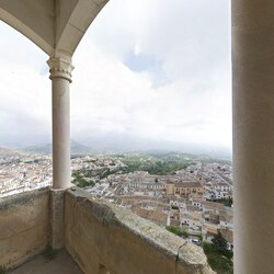
Forging ahead towards the northernmost stop-off point on this route, pass through the villages of Líjar and Albánchez and continue on to Albox, from where the longest section of the route to Vélez-Blanco begins. As you approach the village, the mountain terrain allows you to find places from where you can survey the contours of the village and understand the value of its location as a strategic site to preside over the defence of the vast territory that you are in. The village is crowned with a fortress from the Al Andalus period that is easy to spot from a distance. Its palace-like nature and the renaissance style it was given in a 16th-century renovation divulge its purpose under the manorial administration of the Vélez Marquisate and reveal the legacy left by the humanist movement in other foundations in this village and this Almerian administrative district close to the cultural centre of Jaén. The great stone construction of the castle, looming over the well-maintained limewashed housing, contributes to making this village and its surroundings one of the most significant and most outstanding cultural landscapes in the Vélez region. It is easy to see that when it was built, vantage points were envisaged from the top of its towers and some of its rooms. Many locations in Vélez-Blanco itself are also excellent vantage points from which to observe the María and del Gigante mountain ranges, the Claro river valley where the croplands are irrigated through a complex system that brings water from the basins of the María range, and the eye-catching Pico de la Muela promontory rising above all else.
20 Castle of the Marquises of Los Vélez. ![]()
![]() Renaissance fortress with an irregular floor plan to adapt to the mountain where it is located. It is formed by a square courtyard where different rooms are accessed. It has a square keep that dominates the whole.
Renaissance fortress with an irregular floor plan to adapt to the mountain where it is located. It is formed by a square courtyard where different rooms are accessed. It has a square keep that dominates the whole.
21 Los Letreros' Cave. ![]() This shelter is part of the declaration of
This shelter is part of the declaration of ![]() UNESCO World Heritage Site of the cave paintings of the Mediterranean arc. The shelter is 25 m (82 ft) wide, between 8 m (26 ft) and 10 m (33 ft) high and 6 m (20 ft) deep.
UNESCO World Heritage Site of the cave paintings of the Mediterranean arc. The shelter is 25 m (82 ft) wide, between 8 m (26 ft) and 10 m (33 ft) high and 6 m (20 ft) deep.
22 Ambrosio's Cave. ![]() Cave shelter of great dimensions that houses one of the most important paintings of the Upper Paleolithic of the Peninsula. It is protected as a World Heritage Site by UNESCO and as a Natural Monument of Andalusia.
Cave shelter of great dimensions that houses one of the most important paintings of the Upper Paleolithic of the Peninsula. It is protected as a World Heritage Site by UNESCO and as a Natural Monument of Andalusia.
23 Tower of Montelveche. ![]() Cylindrical tower built in masonry with 3 m (9.8 ft) in diameter. Its base is solid and above it is a vaulted room that had access through a hole on the outside.
Cylindrical tower built in masonry with 3 m (9.8 ft) in diameter. Its base is solid and above it is a vaulted room that had access through a hole on the outside.
24 Historical Center of Vélez-Blanco. ![]() Historic Site protected by its stately architecture of velezan style highlighted by the whitewashed facades, railings next to the main entrance door, three balconies on the upper floor and other smaller ones on the top floor.
Historic Site protected by its stately architecture of velezan style highlighted by the whitewashed facades, railings next to the main entrance door, three balconies on the upper floor and other smaller ones on the top floor.
25 Town hall. ![]() Historicist style building, characterized by a facade with 5 openings, highlighting the central part with ashlar slits and more decoration. The upper floor has 5 balconies, three of them on a ledge as a dust cap that coincides with the central part of the ground floor.
Historicist style building, characterized by a facade with 5 openings, highlighting the central part with ashlar slits and more decoration. The upper floor has 5 balconies, three of them on a ledge as a dust cap that coincides with the central part of the ground floor.
26 Church of Santiago. ![]() Rectangular temple with a single nave of five sections separated by Gothic columns. It has side chapels accessed by semicircular arches. The largest, slightly elevated with respect to the rest of the temple is decorated with paintings and has the image of the Cristo de la Yedra, patron saint of the town. On the outside, its ashlar buttresses stand out.
Rectangular temple with a single nave of five sections separated by Gothic columns. It has side chapels accessed by semicircular arches. The largest, slightly elevated with respect to the rest of the temple is decorated with paintings and has the image of the Cristo de la Yedra, patron saint of the town. On the outside, its ashlar buttresses stand out.
27 Bañones' House. ![]() House of 1861 that stands out for having in its side to the west a gallery of 15 semicircular arches and pillars outlined with moldings. Oval oculi appear above the arches.
House of 1861 that stands out for having in its side to the west a gallery of 15 semicircular arches and pillars outlined with moldings. Oval oculi appear above the arches.
28 Ancient Convent of San Luis. ![]() It has a church with a rectangular floor plan, built with masonry and brick. The doorway has a semicircular arch supported by Tuscan pilasters. In the second body there is a niche between volutes and on the sides the coats of arms of the Vélez family under pediments. The tower of the complex is built with rammed earth, brick and masonry.
It has a church with a rectangular floor plan, built with masonry and brick. The doorway has a semicircular arch supported by Tuscan pilasters. In the second body there is a niche between volutes and on the sides the coats of arms of the Vélez family under pediments. The tower of the complex is built with rammed earth, brick and masonry.
In the area there are also archaeological sites of great importance, although they cannot be visited, such as:
- Maimón's shleters. There are 9 shelters with cave paintings distributed along the east and south face of the Maimón massif.
|
|
Route: Vélez-Blanco, A-317 , A-92N , A-91 , A-7 , A-332 , AL-8105 , AL-8106 , AL-7107 , Sierra Almagrera, A-332 , AL-8105 , AL-8106 , Villaricos, (125 km (78 mi), 1 hr 47 min)

From Vélez-Blanco, turn back to the town of Vélez-Rubio and then turn east to Puerto Lumbreras and, finally, south to Cuevas de Almanzora. From here, head off to Villaricos, a small town by the sea from which you can journey northwards between the Almagrera Mountains and the coast in sight of the mining landscape. Situated in a very arid middle-sized mountain environment, it is possible to see the remains of the old mining complex, which bears witness to an activity that has connoted this and many other Almerian landscapes since the end of the Neolithic age. Mining has left its mark in many places, whereas the exploitation of lead, iron, galena and baryte during industrialisation has produced the most easily recognisable architectural vestiges and contributed the most to the stamp left by mining on this territory. Built between the first third of the 19th century and the mid-20th century, they represent the heritage legacy of some small, scattered villages, processing plants, wells, furnaces and tips. Some small coves on the coast have also been adapted to allow the minerals to be loaded aboard ships. Amongst many other buildings, those at the Jaroso gully, Alianza, Patrocinio and La República mines stand out, as do the La Invencible, La Encarnación, La Nueva and Infalible foundaries and the El Chaparral sluice. Mining has altered the natural appearance of this dark-coloured, rocky territory through the excavation, digging up and blasting of land at many sites. The Mediterranean forest landcover has been affected and here it is populated by holm oaks scattered among an endless mantle of esparto grass.

29 Tower of La Atalaya It is a medieval tower that is in ruins. It has a rectangular plan that reached 4 m (13 ft) in height.
30 Baria They are a series of archaeological sites with a chronological breadth, from the Copper Age to early medieval times. There are Phoenician, Punic, Visigothic and Roman remains, including some hypogeum excavated in the rock.
31 Foundry of La Invencible They are the remains of some facilities where the mineral was treated. It is formed by the smelting chimney, walls of the calcination furnaces, remains of the mining village and the entrance arch to the church.
32 Ore loading dock of Las Conchas' cove This is one of the most important remains of mining in the area. The complex is formed by the inclined plane of the railroad, hopper deposits, three calcination furnaces, a tunnel where the train passed and the remains of the wharf where the ore was loaded.
33 Arteal's Mining Instalalations It is a complex made up of different mining installations, such as a drainage with a 120 m (390 ft) deep shaft, galleries, the entrance to a mine and a village where the workers lived.
34 Mining Rail of Herrerías-Villaricos It was a railroad inaugurated in 1914 that linked the mines of Sierra Almagrera to the shipment of minerals located in Villaricos. Of remains only the layout in the area of Arteal can be appreciated, as well as the double tunnel that crossed Sierra Almagrera.
35 Mines of Barranco del Jaroso It is a group formed by 23 registered exploitations. Chimneys, shafts, tunnels, remains of settlements, ore loaders, etc., are preserved from all of these industries.
36 Foundry of Dolores They are the remains of the old lead smelters that marked the east of Almeria.
37 Sierra Almagrera's Steam Engine It is a set formed by a mining shaft and a two-wheeled wooden mining winch supported by a metal structure containing a steam engine.
|
|
Route: Villaricos, AL-7107 , A-370 , E-15 , AL-3016 , AL-4200 , Rodalquilar, (77.5 km (48.2 mi), 1 hr 5 min)

Leaving to the north of the Almagrera Mountains, return as far as the village again to begin the journey towards the south, passing through high-yielding crop fields around the village of Campohermoso and crossing through the northernmost part of the Cape Gata Mountains, finally arriving at the small mining village of Rodalquilar, by the coast. Nearby, the large factory complex of an old industrial plant where the gold ore from the El Cinto mining preserve was treated and processed and the mining village of Rodalquilar can still be clearly seen in the landscape, as can those on the Cinto and Cuchillo peaks, the Dorr Plant, the Denver complex and other mining villages. In this area, there is abundant evidence of mining since Prehistory and the Classical Age, when the economy linked to alum mining was significant from the 16th century on due to the great demand for the substance in Europe. The mountain slopes in this enclave offer a panoramic view as far as the coast that reveals a rather arid landscape, where conical-shaped peaks diligently shaped by mining activities and industry rise. This territory is also connoted by the existence of features of a culture that developed extensive hydraulic mining, storage and conveyance infrastructure, a very scarce good in the area, as well as by coastal protection, a historical activity with some outstanding examples of architecture such as Rodalquilar Castle, known as Alum Castle, and San Ramón Castle and Los Lobos Tower in El Playazo.

38 San Ramon's Castle It is articulated around a central courtyard. In the part near the sea there is a semicircular bastion where the parade ground was located. The rooms are covered by half barrel vaults.
39 Tower of Los Alumbres Quadrangular tower built in masonry of 14 m (46 ft) high surrounded by a small wall with semicircular towers in its corners. The building consists of two vaulted floors that are connected to each other on the inside. It is topped by corbels that could support the machicolations.
40 Tower of Los Lobos It is a tower belonging to the defensive system of the coast of Almería. It is a truncated building with a base of a diameter of 7 m (23 ft) and a height of 14 m (46 ft). It has three arrow slits and a larger hole that could be the old one to access the interior. In it is installed the current Torre de Los Lobos Lighthouse, which is located at the highest altitude in Spain (265 m (869 ft) above sea level).
41 Rodalquilar's Gold Mines Complex built in the 1950s. It is formed by the different administrative buildings, ponds, sludge deposits, garages, warehouses, a weighing scale of songs and the treatment plant of gold-bearing quartz from which gold was obtained.
42 Cistern of Rodalquilar It is a vaulted cistern located in a ravine. On one side it has buttresses, on the other, it has steps for access to the interior of the same. It has an irrigation channel 50 m (160 ft) long that leads to a settling pond.
43 Waterwheel of Las Negras II It belongs to the typical waterwheel of the area, where you can see the rim of the well from which water was extracted to fill an attached pond.
44 Montano's Country House It belongs to the typical model of Levantine farmhouse, with the traditional volumes and distribution of holes in the area. It highlights the uniqueness of the access terrace to the main houses, generating a recessed U-shaped facade.
There are also important archaeological sites in the area, although they cannot be visited:
- Hill of Cinto Roman archaeological site discovered during mining works. It consists of tombs and disspero material, the tombs having been destroyed.
- Hortichuelas Bajas Archaeological site with scattered material elements related to Roman quarrying and mining.
|
|
Route: Rodalquilar, AL-4200 , AL-3108 , AL-3201 , AL-3115 , Salt Mine's of Cabo de Gata, (29.3 km (18.2 mi) - 35 min.)

Leaving the mountains of the Rodalquilar landscape behind, continue from east to west across the Cape Gata Mountains through the fields of greenhouses and then turn southwards in Ruescas until you reach the Cape Gata salt marshes. An enormous change in the territory can be recognised during this journey, with a stark contrast between the mountain section and the extraordinarily flat landscape that can be seen to the west of Cape Gata. The current state of conservation of the physical environment in this territory, inside the Cape Gata-Níjar Natural Park, and the broad expanse of this working salt marsh offer a view of a landscape of major environmental value in which vestiges of the cultures of different ages stand alongside each other. Mostly related to the exploitation of coastal resources such as fishing and salt extraction, this results in the presence of extraction, processing, communication and transport infrastructure. If you take up a position in the mountain foothills here, close to where the lighthouse stands in the cape, and look towards the coast at the enormous expanse of lagoons and salt pans, you can see that the broad outlines of the landscape are distinctly horizontal, a natural arrangement that contrasts with the vertical buildings in the village, with the church and the slender church tower, the factories, the houses and the piles of salt by the salt flats catching the eye. Less easy to make out is the seawater pumping and feed infrastructure, the contrasts roads between the marshes and the water conduits and drainage channels.

45 San Miguel's Tower Cylindrical tower of masonry built in the 18th century. It is formed by two floors, being reinforced the one below. The upper part is topped by corbels supporting possible machicolations.
46 Salt Mines of Cabo de Gata Wetland of more than 400 hectares formed by the set of pools, warehouse, offices, salt settlement, dry dock, docks, islets, walls and beaches.
47 Torregarcia's Tower Truncated tower built in masonry in the 16th century. Part of its interior is solid, and there is a room on top of it, topped by a terrace. Around it there are remains of Roman salting ponds.
48 San Miguel de Las Salinas' Church Built in 1907 with the village of Las Salinas, it is built on a platform to protect it from the sand and salt due to its proximity to the sea. With a portico at the entrance, it has a single rectangular nave with a barrel vault, the church is topped by a bell tower.
There are also important archaeological sites in the area, although they cannot be visited:
- Tower of La Testa Small site from the Copper Age with hardly any material remains. In medieval times a tower was built, of which only the remains of the starts are left.
Stay safe
[edit]The itinerary passes through safe, low-crime areas. The usual security measures should be taken, such as keeping the car locked or having backpacks or other objects in sight. As in most of the rest of Spain, the rural police force is the Guardia Civil. Larger municipalities may have their own local police officers.
In many places along the route there are no shaded areas, so it is advisable to bring sunscreen and a hat or cap during the hottest periods of the year. Access to many places may not be accessible or even require hiking shoes and clothing or similar.
It should be taken into account that if you walk or drive along raivines, which are dry most of the year, you may be surprised by floods during the rainy season, so check the weather forecast and react quickly in case of unexpected rain.
There are mine shafts along the Sierra Almagrera and Rodalquilar mines; some are signposted but this is not always the case. Walking without precautions can be dangerous.
- Emergencies-112, ☏ 112.

- Guardia Civil, ☏ 062.
Stay healthy
[edit]The nearest hospitals are:
- 1 Hospital Universitario de Torrecárdenas, Calle Hermandad de Donantes de Sangre, s/n., 04009, Almería, ☏ +34 950 01 61 14.
- 2 Hospital del Poniente, Crta. de Almerimar, S/N 04700 El Ejido, ☏ +34 950 02 25 68.
- 3 Hospital de La Inmaculada, Avda. Dra. Ana Parra, S/N 04600 Huércal-Overa, ☏ +34 950 02 91 76.
- 4 Hospital de Alta Resolución de El Toyo (Hospital del Toyo), Camino de La Botica S/N. 04131 Retamar (Almería).
Go next
[edit]Other destinations within the province of Almería:
- 1 Adra Coastal city founded in the 8th century BCE.
- 2 Almería Capital of the province of Almería.
- 3 Níjar Town with a beautiful old downtown.
- 4 Cabo de Gata-Níjar Natural Park land and water natural park with great beaches and beautiful arid landscapes.