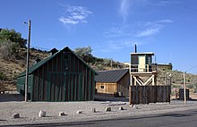
Salina is a city in Central Utah.
Understand
[edit]Salina is a city in Sevier County; the population was 2,660 (2020).
Get in
[edit]
Salina is at the junction of Interstate 70 (exit 56) and U.S. Highways 50 & 89.
Get around
[edit]See
[edit]
- 1 CCC & POW Camp Salina, 700 E. Main, ☏ +1 435-529-7304.
- Eyes to the Sky Balloon Festival. Annual hot air balloon festival that occurs the last weekend in June.
- 2 Miss Mary's Historical Museum, 204 S 100 E, ☏ +1 435-529-4108.
- 3 Peterson–Burr House, 190 West Main.
Do
[edit]Buy
[edit]Eat
[edit]- 1 Lotsa Motsa Pizza, 1417 S State Street, ☏ +1 435-529-4241. M-Sa 11AM-9PM.
- 2 Mom's Cafe, 10 E Main Street, ☏ +1 435-529-3921. M-Th 7AM-7PM, F-Sa 7AM-8PM, Su 7AM-6PM.
- 3 Playa Azul Taco Shop, 1225 S State Street, ☏ +1 435-529-9816. M-Sa 11AM-8PM.
- 4 The Soda Barn, 94 E Main Street, ☏ +1 435-201-1572. M-Sa 9AM-8PM.
Drink
[edit]Sleep
[edit]- 1 High Dessert Inn, 60 N. State Street, ☏ +1 435-529-2120, info@highdesertinns.com.
- 2 Quality Inn & Suites Salina National Forest Area, 1400 S. State Street, ☏ +1 435-529-1300, toll-free: +1-877-424-6423.
- 3 Super 8 by Wyndham Salina/Scenic Hills Area, 375 E. 1620 S., ☏ +1 435-529-7483, toll-free: +1-800-454-3213. Check-in: 4PM, check-out: 11AM.
Connect
[edit]Go next
[edit]| Routes through Salina |
| ENDS at N |
W |
→ Jct |
| Ely ← Delta ← Jct N |
W |
→ Jct |
| Salt Lake City ← Gunnison ← | N |
→ Richfield → Kanab |
| END ← | N |
→ Jct |

