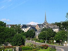
St. Vith (Sankt Vith in German and Dutch, Saint-Vith in French) is a town of about 10000 inhabitants in the province of Liège in the easternmost part of Belgium.
Understand[edit]

Part of the German-speaking part of the country, the town is close to the border tri-point with Germany and Luxembourg. Nearby cities include Verviers and Prüm, whereas the closest major city is the provincial capital Liège. Like the rest of German speaking Belgium, this area was part of Prussia that was awarded to Belgium after the German defeat in WWI. During WWII, the town was retaken by Germany for a few years. The area saw heavy fighting and after the war around 90% of St. Vith was in ruins. The rebuilding took well into the 1960s. Today the town profits from the closeness of the economically strong Luxembourg.
Tourist offices[edit]
- 1 Agence du Tourisme de l'Est de la Belgique, Hauptstraße 54, ☏ +32 80 227664, info@ostbelgien.eu. M-F 8:30-12:30, 13-18. Disability friendly (2 steps at the entrance separated by a large step)
- 2 Tourist-Info Saint-Vith (Tourist-Info Sankt Vith), Rathausplatz 1, ☏ +32 80 280130, touristinfo@st.vith.be. M-Sa 9-12:30, 13-15:30. Disability friendly.
Get in[edit]
By plane[edit]
The closest passenger airports are in Liège and Luxembourg, though the former is mainly for holiday charter flights to places around the Mediterranean.
By train[edit]
The closest railway station is in Vielsalm, about 20 km to the west. Trains between Liège and Luxembourg city stop here.
By bus[edit]
Bus line 394 of the Wallonien operator TEC connect from Eupen a couple of times a day on workdays. Eupen in turn has bus connections from Aachen in Germany and is the eastern end of hourly train services across Belgium from Brussels and Ostend.
Perhaps surprisingly, bus connections from Luxembourg are much more frequent, bus 173 from the northern town of Troisvierges (that also has a railway station) are almost hourly, including some buses on Saturday and Sunday.
By car[edit]
St. Vith can be reached along motorway E42 from the direction of Liège and much of the rest of Belgium. From the south, the same motorway comes in Germany (Trier, Saarbrücken etc.) - in Germany it's labeled as Autobahn A60. Highway N62 comes in from northern Luxembourg.
By bike[edit]
The Vennbahn (a former rail line turned into the bikeway) bike routes 47 and 48 meet in St. Vith, and the town is also the terminus of the Eifel-Ardennen-Radweg.
Get around[edit]
See[edit]

- 1 Heimatmuseum "Zwischen Venn und Schneifel", Schwarzer Weg 6. Local history museum in a building once built as infrastructure to serve the Vennbahn railway, and also has an exhibition on the railway.
Do[edit]
Buy[edit]
There are several large furniture stores, just like in other towns in the region.
Eat[edit]
- 1 Restaurant An den Linden, An den Linden 1. Belgian and international cuisine. Mains €20-35.
Sleep[edit]
- 1 Relaxhotel Pip Margraff, Hauptstrasse 7, ☏ +32 80 22 86 63, info@pip.be. single rooms from €80.
Cope[edit]
- 3 Saint-Joseph Clinic (Klinik St. Josef), Klosterstraße 9 (bus stop An den Linden), ☏ +32 80 854411. always open. Disability friendly. Nighttime emergency entrance at the southern end of the building.
Go next[edit]
- Hike in the Our river valley (including the Belgium-Germany-Luxembourg tripoint)
- Bike or hike in the Hohe Venn hills.
- Eupen, the other larger town in German Belgium
- Signal de Botrange, at 694 m ASL the highest point in Benelux is about halfway between Eupen and St.Vith. The aforementioned bus service from/to Eupen passes the place.
- Liège, the largest city in Wallonia
- Spa, the Spa
- Luxembourg is just 15 km to the southwest, Germany 10 km southeast. Kneiff, the highest point in Luxembourg is just a kilometer from the bus stop served by the line to/from Troisvierges, meaning two country high points are accessible by public transit from St. Vith. If you're collecting country high points, the highest point in the Netherlands is Vaalserberg at the Belgium-Germany-Netherlands country tri-point which in turn is accessible from Eupen by local bus plus a short hike...

