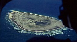
Tromelin Island is a minor one of the islands of the Indian Ocean, approximately 800 km (500 miles) east of Madagascar and 800 km north of Réunion. It makes up one of the many Scattered islands of the Indian Ocean, which is one of the five administrative districts of the French Southern and Antarctic Lands.
Understand
[edit]
Tromelin Island is not open to tourism. It is uninhabited, and serves as a sea tortoise and seabird sanctuary. The only facility on the island is an important meteorological station which gathers data for forecasting cyclones and hurricanes. First explored by the French in 1776, the island came under the jurisdiction of Reunion in 1814. The island was discovered when the French ship Utile, which was carrying slaves at the time, hit the reefs of the island. The crew got on a floatable raft to make it to Madagascar, while they left 60 slaves on Tromelin Island. 15 years later in 1776, the chevalier de Tromelin (from whom the island takes its name), captain of the French warship La Dauphine, came upon the Island and rescued the slaves that were still alive — seven women and an eight-month-old child. Tromelin Island was occupied by France in 1954 while it was part of Mauritius and it is claimed by Mauritius.
Terrain
[edit]The terrain on Tromelin Island is sandy, flat, low and is likely volcanic. The island is also surrounded by coral reefs. The Island also has volcanic rock.
Climate
[edit]The climate in Tromelin Island is tropical.
Animals
[edit]The island is a nesting ground for seabirds and turtles. It is also a conservation area for unique vegetation and rare bird life.
Land use
[edit]arable land: 0% permanent crops: 0% permanent pastures: 0% forests and woodland: 0% other: 100% (scattered bushes)
Get in
[edit]
By plane
[edit]There is an unpaved airstrip on the island, meaning that when a plane lands, it lands on a dirt path unlike cement at airports.
By boat
[edit]Tromelin has no harbors; offshore anchorage only.
Get around
[edit]Everything is within walking distance.
Buy
[edit]There are no businesses on the island.
Sleep
[edit]There are no accommodations open to the public.


