Central Newfoundland is part of the Canadian province of Newfoundland and Labrador.
Communities
- 1 Baie Verte — primarily a mining town, it offers visitors iceberg watching, historical mining sites and hiking trails
- 2 Grand Falls-Windsor — the largest city in and the main service centre of the region
- 3 Lewisporte — a deep-water port and shipping centre on Notre Dame Bay
- 4 Wesleyville — a town created in the 19th century when people were resettled from nearby islands
- 5 Gander — a small city with a large airport that became famous for taking in 6,600 stranded trans-Atlantic flight passengers when planes were forced to land on Sep 11, 2001
- 6 Gambo — known for its Smallwood Days celebration and its Loggers' Sports Festival
- 7 Glovertown — a small, seaside town that is a stepping-off point for Terra Nova National Park
- 8 Pilley's Island — a mining town
- 9 Twillingate — the "Iceberg Capital of the World" known for its scenery and the icebergs that are seen offshore in the spring months
Other destinations
- 1 Fogo Island and Change Islands — about 100 islands strung out described by Captain Wadham as “a parcel of dammed rugged isles”.
- 2 Little Bay Islands — once home to 500 people, almost all of the remaining 55 residents were relocated in 2019, leaving the town vacant
Understand

The economy of the centre of Newfoundland is based on forestry, and pulp and paper, so the terrain is, of course, heavily forested. The coast along the north of the region, however, is rugged and spectacular. Historic fishing villages are perched along the craggy coastline and spread through scattered islands connected by causeway or by ferry.
People settled on the coast, like most of Newfoundland, to fish for cod. Cod sustained people for centuries. In 1992, the government imposed a moratorium on fishing for cod, and the cod fishery was closed. The upheaval throughout rural Newfoundland was devastating with hundreds of small rural communities – outports – losing their livelihoods almost overnight. Fogo Island and Change Islands have fared better than many other remote fishing communities. Many of the fishermen of Fogo Island have adapted their fishery to other species such as crab and shrimp. Tourism also provides some support to the coastal communities.
Newfoundlanders are well-known for their folk music, and of the most famous Newfoundland songs is I'se the B'y ("I am the guy"). The lyrics list some of comminities of the islands:
- I took Liza to a dance / As fast as she could travel
- And every step that she did take / Was up to her knees in gravel.
- Hip yer partner, Sally Tibbo / Hip yer partner, Sally Brown
- Fogo, Twillingate, Moreton's Harbour / All around the circle!
Get in
- 1 Gander International Airport (YQX IATA). Served by Air Canada and Sunwing Airlines, with daily flights from St. John's and Halifax.
- By car, Grand Falls-Windsor is about 430 km (4 hr 45 min) west of St. John's, 210 km (2 hr 15 min) east of Deer Lake, and 475 km (5 hr) east of Port Aux Basques, when travelling on the Trans-Canada Highway.
- DRL Bus. One bus daily from St. John's, and one bus from Port aux Basques to Grand Falls-Windsor, Lewisporte and Gander.
Get around
The Trans-Canada Highway (#1) is the east-west route through the region, while provincial highways 330 and 340 will take you north to the coast.
See and do

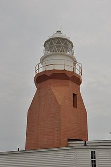
Long Point Lighthouse, a few minutes from Twillingate, has a beautiful area for looking out over the ocean to view whales and icebergs.
Fogo Island and Change Islands offer stunning natural wildlife and scenery such as humpback whales, caribou herds, soaring seabirds, and towering icebergs.
The North Atlantic Aviation Museum in Gander explores the history of aviation in Gander, once an important refuelling stop on trans-Atlantic flights. Museum exhibits cover wartime operations during World War II and the town's role in hosting 6600 travellers when 38 civilian and 4 military flights diverted to Gander during the September 11th, 2001 attacks.
Walking trails from Fogo lead to resettled villages of Lion's Den, Shoal Tickle, Eastern Tickle and Locke's Cove. Also, there are trails to scenic Brimstone Head, Fogo Head and Waterman's Brook.
Take a boat tour from Twillingate to see the icebergs. Early July is usually the best time.
Eat
In the coastal fishing communities, fresh seafood, of course.
Drink
- Auk Island Winery, Twillingate. Do a wine tour and taste wines made from local berries and iceberg water.
Stay safe
When driving, keep your eyes peeled for moose on the highways. Especially in the spring rutting season, moose will dart from the forest onto the highways. Car-moose crashes are frequent and are a serious cause of fatalities (human and moose). An encounter between a car and a 500-kg, 2-m-tall moose at high speed is something to be avoided.
Go next
- Gros Morne National Park, about 200 km to the west.

