
Kolari is a municipality in Finnish Lapland, best known as the northernmost railhead in Finland, with overnight trains from southern Finland. Most tourists continue from the town itself to Ylläs or other resorts.
Understand
1 Yllästunturi (Ylläs fell) by Pallas-Yllästunturi National Park, 35 km away from the railway station and the administrative centre, is by far the most important destination in the municipality. During the winter sports season the villages 2 Äkäslompolo and 3 Ylläsjärvi are crowded with skiers. Otherwise the municipality is largely forest and swamps, including an important bird site, with some fells in the west.
The river Muonionjoki is an important salmon river and salmon fishing is the major attraction during the summer months.
Historically Kolari was famous for its mines. There are several closed mines around the municipality and the large iron ore resources are still in interest of many international mining companies. Today tourism is the main source of income, and the question about how well the mining industry would fit with it is a hot topic among the locals.
Get in
The municipality, at the Swedish border (by Pajala), has one of the northern railheads, with overnight trains from southern Finland.
By plane
The nearest airports are in Kittilä to the east and in Pajala across the border to Sweden. Rovaniemi, farther away but with better connections at least off season, is another option.
For small private planes there is the 1 Aavahelukka air field (EFAA), used by the local flying club.
By train
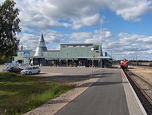
2 Kolari train station is the northernmost train station in Finland. During the winter season there is a direct train connection daily from Helsinki via Tampere; at 995 km, this is the longest single train route in Finland. An overnight trip takes 13 hours and is most comfortable in a sleeping cabin. Sometimes the train contains a special club car serving as a nightclub during the trip. The train also carries cars from Helsinki.
By bus
Daily connection from Oulu, Kemi and Tornio is available. See timetables from Matkahuolto.
By car
From Helsinki, drive by E75 to the north. Switch to E8 after Kemi.
From Sweden there is a bridge at 3 Kolari border crossing about 3 km south from the municipality centre. There are bridges also at Haparanda/Tornio, Övertorneå/Ylitornio (Aavasaksa), Pello and Karesuvanto.
From northern Norway use E8 from Tromsø, road 93 via Kautokeino or E75 via Tana. From E75 you can turn at Sodankylä and continue via Kittilä.
Get around
Matka.fi includes information about some long distance bus routes which can be used for local travelling.
The town is mostly built along the Muonionjoki river and its Saaripudas fork. The train station is in the north end. The Kolari and Kolarinsaari churches are some 3 km downstream, the latter across the Kolarinsaari bridge. The bridge over Muonionjoki is 3 km further downstream, in the south end of the town, 25 km from Pajala centre.
The island Kolarinsaari is some 7 km long, sparsely settled near the bridge in the south. The settlements in the north are adjacent to Saaripudas on the Finnish side and the Swedish Kolari village (there was no border here before the 19th century).
See

In and near the centre
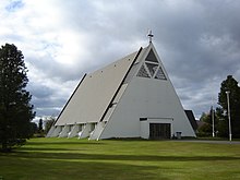
- 1 Kolari church, Pappilantie 4. The new church was built 1965.
- 2 Kolarinsaari church, Siltatie 4. The Kolari old church was built 1818–1819 and is included in the list of nationally significant built cultural environments. The church is in use only during special occasions in summer and the service in the Christmas Eve.
- Kolarinsaari island
Farther away
- 3 The municipal museum of Kolari (Sieppijärven kotiseutumuseo), Rovantie 3 (in Sieppijärvi, 24 km southward from Kolari centre), ☏ +358 40-489-5316, museo@kolari.fi. mid-June to August Tu–Sa 11:00-17:00, Su 12:00–16:00. A local history museum in 18th and 19th century buildings with old local household items. Short culture oriented trail.
Do
- 1 Lukkarinvainio nature trail. A circular 3.5 km long trail starting from the Kolarinsaari church going around the southern part of the Kolarinsaari island. There is a campfire site on the trail.
- Snowmobiling; a day hut, lean-to shelters and similar service along the route not far away, the routes extend to most of Lapland.
- For salmon fishing you need to buy a licence. Most accommodations near Muonionjoki river will arrange these.
- 2 Teuravuoma-Kivijärvenvuoma Protected Mire Area (8 km to the east along Kurtakontie, road 80, then 3.7 km along the road to Teurajärvi, to the right). Three aapa mire complexes, including open fens and forested pine bogs and spruce swamps. This 58 km² mire complex is among the largest in the whole of Europe and one of the best bird watching sites in central Lapland. Telatie is an 11 km duckboard trail between Venejärvi and Kurtakko villages, built originally in the 1880s and renovated in the 2000s. The trail is on the list of nationally significant built cultural environments. Easy routes with duckboards, lean-to shelters, campfire sites and observation towers. The observation tower at Teurajärvi, 1.4 km from the road, gives a very nice view. Kurtakko, another trailhead near Kurtakontie (1.5 km), is a 13 km hike away (i.e. 16 km in all with public transportation). Get mosquito repellent.
- 3 Niesikero nature trail. An easy 2.7 km long nature trail with lean-to shelter and observing tower.
Buy
- 1 Wood jewel, Jokijalantie 1 (by E8, halfway between the church and the railway station), ☏ +358 50-366-8980, kauko.raatiniemi@pp.inet.fi. Knives, fishing lures and souvenirs, including wooden jewellery. Café with lunch.
Eat
- Ravintola Meän Paikka, Muoniontie 1 (by the hotel, at E8 by the railway station), ☏ +358 40-717-6397. 10:00–20:00 daily. Menu tongue in cheek in the local dialect, often foreign dishes with a local twist or local ones with international touch. €14–25.
- Kolarin Burger & Majat, Muoniontie 2 (opposite the hotel, at E8 by the railway station), ☏ +358 40-516-1204, kolarinburger@gmail.com. M–Th 12:00–22:00, F–Sa 12:00–24:00, Su 14:00–22:00. Burgers, pizza & al.
Drink
Sleep
Lodgings in the Ylläs area and farther in the national park are not included here. See Ylläs and Äkäslompolo for a number of lodging alternatives from hotels to cabins at or near the ski resorts, Pallas-Yllästunturi National Park for cabins and huts in the park itself.
Here are lodgings in the town or otherwise closer to the Muonionjoki river:
- 1 Hotel Kolari, Muoniontie 1 (360 m from the train station), ☏ +358 400-127-463, hotelli@hotellikolari.fi. Breakfast included. Sauna. Free Wi-Fi. Social dancing with live music about weekly. single €85, double €105.
- 2 Rantalan majat, Muoniontie 120 (11 km northward, upstream, from the railway station), ☏ +358 40-533-1326, info@rantalanmajat.fi. Apartments, cabins, caravan places and camping. Fishing gear and licences. Fishing guide service. apartments €60–120, cabins €60, tents and caravans €15+€5/person.
- 3 Jokisuun Maja, Muoniontie 150 (17 km northward from the railway station, at Äkäsjoki, near its mouth), ☏ +358 400-310-840. Apartments for 1–5 persons, hostel, caravan places (electricity, WC, shower) and camping (WC, shower). Canoe for hire. rooms from €65 (linen +€15/person), hostel bed €20/night (May–Sep), caravan €25 (2 persons) + €7 for electricity, tent €10 + €5/person, sauna €25/h (2 persons).
Connect
- 4 Library, Isopalontie 2, ☏ +358 40-489-5014, kolari.kirjasto@kolari.fi. M–Th 11:00–19:00, F 10:00–17:00, Sa 10:00–15:00. Also computers and Wi-Fi.
Go next
- Ylläs or Äkäslompolo, ski resorts, also usable as a base for hikes.
- Pallas-Yllästunturi National Park, the most visited national park in Finnish Lapland, with an old hiking trail to Hetta and well-developed services.
| Routes through Kolari |
| Kilpisjärvi ← Muonio ← | N |
→ Pello → Tornio |
