Appearance
The Niuas are the northernmost islands of Tonga.
Understand
[edit]Islands
[edit]- Niuatoputapu is 240km north of Vava’u and has 18 sq. km with a population of around 1400. Tradition is still important here with conservative ways of dressing and behaviour. It has beautiful white beaches, particularly on the north-west side of the island. Niuatoputapu was severely damaged by the September 2009 tsunami that also devastated southern Upolu in Samoa.

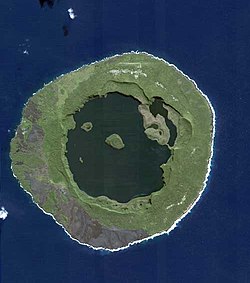
- Niuafo’ou is the northernmost island of Tonga. Other names for the island are Good Hope island and Tin Can island. The latter originated from the fact that in earlier times mail was delivered and picked up by strong swimmers who would retrieve packages sealed up in a biscuit tin and thrown overboard from passing ships. Stamps from that time have become a collector’s item. It is the tip of an underwater volcano created by sub-oceanic eruptions. The last eruption was in 1946, after which the whole island was evacuated for ten years. Fields of lava are still evident. The island ring encloses two lakes.
- Tafahi — a tiny volcanic "satellite" island of Niuatoputapu.
Get in
[edit]Get around
[edit]See
[edit]Do
[edit]Buy
[edit]Eat
[edit]Drink
[edit]Sleep
[edit]Plan ahead to arrange a home stay with the Tonga Visitor’s Bureau.

