Appearance
Franklin is a city in Warren County, Ohio.
Get in
By car
Franklin lies at the intersection of I75 and SR73.
By bike
The Great Miami River Recreation Trail connects to Miamisburg.
Get around
See

- 1 Franklin Historical Society Museum (Harding Museum), 302 Park Avenue, ☏ +1 937 746-8295. F 10AM-3PM. Built in 1901, this former residence of General E. Forrest Harding now houses a museum dedicated to the history of Franklin.
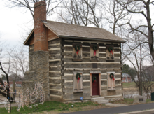
- 2 Old Franklin Post Office. A historical log post office that was commissioned by Thomas Jefferson in 1805.
- Museum of Spiritual Art, 318 S River St, ☏ +1-937-557-3444. Art that transcends the immediate physical realm representing multiple world religions.
Do
- 1 Crains Run Nature Park.
Buy
Eat
Drink
- Franklin Tavern, 331 S Main St, ☏ +1 937 743-6111.
Sleep
- Hampton Inn & Suites Springboro/Dayton Area South, 25 Greenwood Ln, Springboro, ☏ +1 937-743-2121. Typical Hampton Inn design but with an indoor pool. $90 (Feb 2022).
- Holiday Inn Express & Suites Dayton South Franklin, 851 Commerce Center Dr, ☏ +1 937 746-1094. Check-in: 3PM, check-out: noon. $90.
Connect
- Franklin Public Library, 44 E 4th St, ☏ +1-937-746-2665.
Go next
| Routes through Franklin |
| Dayton ← Springboro ← | N |
→ Middletown → Cincinnati |


