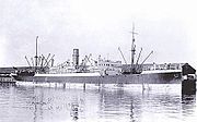
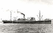
The dive site Wreck of the SS Cariboo or SS Cariboo is an offshore historical wreck in the Keiskamma area, near Port Alfred in the Eastern Cape province of South Africa.
Understand
This is a wreck which has not been dived much by recreational divers, though salvage work was done in the late 70s or early 80s to recover part of the cargo of blister copper ingots. The attraction of the wreck is largely that it is virtually unknown.
The Cariboo was wrecked on 24th November, 1928 near Keiskamma, about 40 miles south of East London, on passage from Beira for New York.
In June 2011 a group of divers from Cape Town and Bloemfontein carried out a search for the wreck, and were successful in locating at least part of it. Visibility was poor (<0,5m on the wreckage) and the full extent of the wreckage was not mapped as it was only safe to launch on one day.
| Tonnage | 7275 | grt | |
| Length over all | 134 | .2 | m |
| Beam | 18 | .0 | m |
| Draft | ? | m | |
| Indicated power | ? | Hp | |
| Propulsion | ? | Steam turbines by Harland & Wolff Glasgow | |
| Screws | ? | ||
| Speed | ? | knots | |
| Builder | John Brown, Clydebank | ||
| Yard No. | 599 | ||
| Ship Type | Cargo Vessel | ||
| Previous Names | laid down as "Cavally" | ||
| Port of Registry | Liverpool | ||
| Launched | Saturday, 22/03/1924 | ||
| Owner History | Elder Dempster & Co., Liverpool | ||
Position
- Roughly S33°26' E27°18'
Bearings:
- About 340° magnetic to the mouth of the Mgwalana river
Description of location:
- About 3.4 km offshore. The wreck appears to be at least partly on reef in an area where the bottom is predominantly sand.
- This site is not in a Marine Protected Area. A permit is not required.
Name
The site name "SS Cariboo" is the name of the ship wrecked at this site in 1928
Depth
Maximum depth recorded is about 35m. and the top of the wreckage is at about 30m. It is quite possible that unexplored parts of the wreck are deeper and/or shallower than this.
Visibility
Visibility can be extremely poor, but it is expected that it will be similar to other sites along this part of the coast. It is possible for visibility at the surface to be quite good, but a sudden deterioration may occur at depth. (visibility of about 5m at the surface, total darkness and 0.5m visibility at 30m)
Topography
Only a small part of the wreck has been explored, and it appears to be at least partly collapsed. The known wreckage seems to be deck structure, or possibly superstructure. There is a lattice of frames with the remains of plating, and a small winch, possibly part of the cargo handling system. This section of the wreckage lies at least partially on rocky reef.
Geology: Sedimentary rock of unknown formation, Probably like the shoreline reefs nearby. Strike probably roughly north west-south east, Dip likely to be quite steep if the same formation as the shoreline reefs
Conditions
The site is likely to be at it's best in late summer, but there are may be occasional opportunities in other seasons.
Access is limited by surf conditions at the launch site. If a boat can be launched at Begha mouth, the sea is flat enough that the wreck can be dived
Get in
The site is only accessible by boat.
The site is about 9 km from the beach launch site just north of Begha Mouth. or about 42km from the mouth of the Kowie river at Port Alfred
There is adequate parking on the beach, but access must be arranged with the local boat club at Bagha Mouth Access to the launch site is over the beach, about 1.5km from the nearest access road at the river mouth. The sand and the intertidal area is moderately firm, but can be soft in seepage areas and on dunes. Drive to the mouth of the Begha river on the east side, and along the beach until you are east of the offshore reef. Launch area is marked by a wooden pole several metres high in the sand above the high water mark. The shore is very flat in this area and the boat will have to be launched in very shallow water, turned and manhandled into deeper water, and held by the crew and passengers while waiting for a lull in the waves. The launch conditions are limited as the boat must be driven directly out and can usually not run parallel to the break to find a gap as the water is too shallow. Return will usually be less of a problem as the boat may be beached at speed — the beach sand is fine and free of reef and pebbles at the launch site. This is a launch which should not be attempted by skippers who are not experienced and skilled in surf launches.
The launch area is to the east of the Madagascar reef, which gives some shelter from south westerly swell.
Access from Port Alfred is also limited by conditions at the river mouth, and it is a long run there and back.
See
Marine life
Large numbers of small gorgonian sea fans have been seen on top of the wreckage.
Features
Wreckage of a large steel cargo vessel of the early 20th century
Photography
Suggested Routes
No known routes. The wreck is mostly unexplored, and more information is needed.
Stay safe
Hazards
The launching and beaching has been discussed in the "Get in" section. The site is far from thr nearest decompression chamber, do not risk a bend. In poor visibility use great care to avoid injury or entrapment in the wreckage.
Skills
Skill and experience in diving on wrecks is recommended. Appropriate certification for diving below 30m would be required by most operators. The wreck is in an area where moderate to strong currents may be expected, and the ability to surface on a DSMB is recommended, as it may not be practicable or convenient to surface on the shotline.
Equipment
If visibility on the wreck is poor, reduce the risk of entrapment by either laying a line from the shotline, or towing a surface buoy. These procedures will ensure that you can find your way out if you inadverently swim into an overhead environment in the darkness.
Back to Diving in South Africa#Eastern Cape or Diving the south coast of South Africa


