
Diving at the SS ''Cape Matapan''

The dive site SS Cape Matapan is an offshore historical wreck in the Mouille Point area of Table Bay, near Cape Town in the Western Cape province of South Africa.
Understand
[edit]
The Cape Matapan was a steam powered fishing boat of the Irvin and Johnson fleet, built in 1925, which was slowly returning to Cape Town harbour in heavy fog in 1960 when it was accidentally rammed by another vessel leaving the harbour. The Matapan sank rapidly, but all the crew were rescued by the other vessel, which made it back to the harbour. The position of the wreck was not accurately known due to the conditions at the time of the sinking, but was reported to be about 30 minutes at low speed from the breakwater.
A group of divers from False Bay Underwater Club and Blue Flash diving charters made a search in the estimated area in late October 2010. The initial search on parallel compass courses was unsuccessful, bur a trial run using a towed sled on an arc around the estimated position hit paydirt, and the diver cut loose and investigated some wreckage seen on the bottom. This included a section of bow structure, a hawse pipe, and several plates. A second dive was done a couple of weeks later to begin a survey of the site, and the boiler was found. So far the wreckage has not been positively identified, though many artifacts correspond with the only known photograph of the vessel. The site has been named the Cape Matapan until evidence indicates that it is a different wreck. It is apparent that salvage work was done on this wreck in the past, as the hub of the propeller has had the blades removed, possibly by blasting.
The surrounding reef has a reasonably representative variety of the local reef life.
Position
[edit]- 1 SS Cape Matapan (boiler): S33°53.233' E018°24.533'
About a kilometer north of the wreck of the RMS Athens
This site is not in a Marine Protected Area. A permit is not required.
Name
[edit]
The name "SS Cape Matapan" is the name of a vessel sunk in this area, and thought to be the wreckage at the site.
Depth
[edit]Maximum depth is about 25 m. The bottom is almost flat and most of the wreckage does not stand very high, so the average depth is probably about 23 m, with the top of the boiler at about 21 m. There are a few rocky ridges in the vicinity, but none higher than about 2 m.
Visibility
[edit]Visibility in Table Bay is often at its best after a south easterly wind. It can be as good as 15 to 20 m, but is more likely to be between 5 and 10 m on a diveable day. After north-westers, usually in winter, the visibility may be very poor.
Topography
[edit]

Low profile blocky rocky reef, largely bedrock, with small blocky boulders and shingle. Virtually no sand, even in the low-lying areas. This may be seasonal, and the low flat rock is relatively bare.
Wreckage includes: Hawse pipe, anchor, anchor winch, part of the forefoot, various pieces of side and bottom plating with frames, and other odds and ends of plate and sections, all low and fairly widely scattered.
There is also a three firebox scotch boiler about 4 m diameter, structurally intact, a large steam powered winch with wire cable on drums, and part of the winch engine, a long large bore pipe, possibly a mast, bits of brass tube and pipe, a couple of porthole frames and components, a large deck mounted sheave or turning block, some valves and flanged pipe fittings, and a scattered mass fragments of plate and frames. There is also a mechanism which might be a feed water pump, and what may be part of the rudder. Most of the smaller objects are heavily encrusted and not easily identifiable. Many of these items have been identified on the map, but not with any great accuracy.
The debris field found so far is about 35 m radius centred on the boiler. To the north west of a line between the boiler and the forefoot are a large number of small scraps of structural plating and frames.
Geology: Pre-Cambrian sedimentary rock of the Tygerberg formation. Strike approximately north/south, Dip almost vertical.
Conditions
[edit]The site is exposed to wind and waves from the north west, and to a lesser degree from the southwest, so should be dived the south west swell is low or short period. It is likely to be good in south easterly winds, as long as they are not too strong.
The site will usually be at it's best in summer, but there will also be occasional opportunities at other times.
This is an area which sometimes has very strong offshore winds, which can come up quickly, but are usually predictable a few days ahead. Watch the weather forecast. A strong south-easter will usually not affect underwater conditions, but will make the boat trip wet and uncomfortable, and may make it difficult for the crew to see divers in the water. The wind will also blow a diver on the surface towards the shipping lane.
Expect cold water. 14°C would be considered warm, and temperature could be as low as 9 or 10°C
Get in
[edit]Boat dive, usually from Oceana Power Boat Club, or from the V&A waterfront. The site is about 1.7 km from Oceana Power Boat Club, and is just on the outside edge of the main shipping lane serving Cape Town harbour, in the inshore traffic zone.
There are day charter boats which can take a diver to any of the dive sites in the region, but most operators only work from a limited number of launch sites, which limits the dive sites they visit. Visits to a dive site also depend on the weather and are generally not predictable or bookable more than two to four days in advance. See the listing for Cape Peninsula and False Bay boat dive charters and the associated services directory for contact details.
See
[edit]Marine life
[edit]The wreckage is thinly encrusted with corallines and invertebrates. Occasional clusters of sponges, colonial ascidians feather stars etc and some large lacy bryozoans. The boiler has more soft coral, anemones and false corals, particularly inside. The surrounding reef is much the same in the flatter areas, but the ridges have some colourful clusters of sponges, soft corals and false corals and the occasional nudibranch. Fairly large numbers of Hottentot seabream swim around in shoals, as is usually the case in a relatively high profile part of a reef in this region.
 Typical reef in Table Bay near the Matapan wreck.
 There are some patches of colour on the reef


Features
[edit]Wreckage from a moderately recent wreck of some historical interest. The wreckage has not yet been positively identified, but is all consistent with the available information about the ship. It includes a Scotch boiler with two fireboxes in fairly intact condition, two large steam powered winches, an anchor of the same pattern visible in the photo of the ship, and a pile of wreckage of machinery.
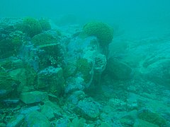
 Hawse pipe of the wreck
 Forefoot of the vessel (where the bow and the keel meet)
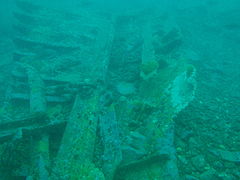 Hull plating with frames
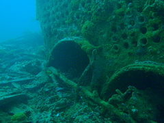 Two of the fireboxes on the boiler can be seen here
 One of the masts
 One of the steam powered winches
 Wreckage of the Cape Matapan
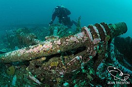 Diver swimming over a clump of wreckage near the boiler
 The boiler


Photography
[edit]If the visibility is really good, natural light photos of the wreckage may give interesting results, otherwise, Macro photography for the limited reef life, or wide angle photos of the wreckage.
Suggested Routes
[edit]The shot should be dropped near to the boiler, as it is the best landmark, and may be picked up on an echo-sounder.
Depending on your interests, you can spend the dive investigating the pile of debris to the south west of the boiler, or cruise around looking at the overall picture.
If you want to see a large part of the site in one dive, the following route may suit your needs. Starting at the boiler, swim a course of 160° magnetic. After about 15 m you should see a flat plate about 3 m by 3 m with raised rubbing strips, some on the diagonal. Continue on this course over a section of hull plating with visible stiffeners, to a section of the forefoot (the transition between the stem and the keel). Just beyond this is a hawsepipe standing up at about 45°, and balanced on the hawsepipe flange.
There is not much of interest recorded from further south or east, so at this point you may wish to turn and return to the main wreckage, taking in the anchor, anchor winch, main mast and main winch on the way. These are laid out parallel to the route you took to get to the hawsepipe, but slightly to the south west (probably about 10m on average).
Beyond the winch, to the north east the boiler should be visible, and straight ahead is the mound of assorted machinery, piping and structural steel. A shaft with four rings is probably the most conspicuous single item in this assemblage of strange bits of ship, and there are two connecting rods which may have been part of the main engine.
Stay safe
[edit]Hazards
[edit]The site is very close to a major shipping lane. Ensure that the dive boat is flying the appropriate signals, and be very careful when surfacing. The size of ship that uses this area is not able to stop or avoid a person in the water, and may draw 10 m or more, so you would not necessarily be safe near the bottom if one were to go overhead. The boiler has survived many years, so one can assume that you will be safe from most ships at that depth.
Skills
[edit]The ability to deploy a DSMB and navigate by compass is strongly recommended. It may be necessary to surface away from the shotline and this site is near a major shipping lane.
Equipment
[edit]A DSMB to indicate your position while surfacing, and a compass to ensure that you do not wander into the shipping lane are strongly recommended.
Nearby
[edit]
- 1 MV Afrikaner
- 2 Highfields
- 3 Two Oceans Aquarium
- 4 RMS Athens
- 5 SS SA Seafarer
- 6 MV Gemsbok
- 7 Three Anchor Bay
- 8 Sea Point Ridge Pinnacles
- 9 Bantry Bay
- 10 North Lion’s Paw Main Reef
Back to the Alphabetical list of sites, or list of dive sites in the Table Bay area
Other regional dive sites:
- Dive sites of the Cape Peninsula west coast
- Dive sites of the Cape Peninsula east coast
- Dive sites of False Bay offshore and approaches
- Dive sites of False Bay east coast
- Fresh water dive sites of the Cape Town Metropolitan Area