Eastern Newfoundland is the region of the Canadian province of Newfoundland and Labrador that includes the Avalon Peninsula, which extends farther east than any part of North America except Greenland, and the Bonavista Peninsula, which was the site of the arrival of the first European colonists to North America, in 1497.
Cities
[edit]Avalon Peninsula
[edit]- 1 St. John's — the capital, largest city in the province, and the oldest city in North America
- 2 Conception Bay South — a collection of nine communities that make up a suburb of St. John's
- 3 Mount Pearl — a suburb of St. John's that hosts over 60 km of walking trails
- 4 Branch — it claims to be "the nicest place in the world"
- 5 Carbonear — an historic town overlooking Conception Bay
- 6 Dildo — after you take a picture of the town sign, stay and enjoy the scenery
- 7 Saint Shott's — an unusual number of shipwrecks have accumulated in the waters off its coast over the last five centuries
- 8 Placentia — a group of six fishing villages on the west side of the Avalon Peninsula
- 9 — Bonavista's lighthouse is one of Newfoundland's most photographed sites
- 10 Clarenville — a quaint town that is a service centre for the Bonavista Peninsula
Other destinations
[edit]- 1 Trepassey and the Irish Loop – a large rural area on the southern portion of the Avalon Peninsula includes a string of tiny seaside villages, a
 UNESCO World Heritage Site listed archaeological site at Mistaken Point Ecological Reserve, the Avalon Wilderness Reserve and the first point of contact for trans-Atlantic ships, Cape Race.
 - 2 Terra Nova National Park — a place where sheltered Atlantic fjords stretch inland to touch the boreal landscape
- 3 Eastport Peninsula — a popular vacation destination with excellent beaches, fishing villages and an active arts community
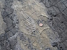
- 4 Mistaken Point Ecological Reserve, a
 UNESCO World Heritage Site famed for its Ediacaran fossils.
Understand
[edit]The first overseas outpost of England was established at St John's in August 1583. Eastern Newfoundland drew Europeans to the historic Avalon Peninsula chasing the seemingly infinite North Atlantic cod schools over the following centuries, until the party came to an end in 1992 and the cod fishery was closed. Much of the region has suffered economically since then, but is recovering as other industries expand, including tourism.
Get in
[edit]- Marine Atlantic runs a ferry from North Sydney, Cape Breton to Argentia, near Placentia; crossing time is about 14 hours. Another option is to cross by ferry to Port-aux-Basques (about six hours) and take the Trans-Canada Highway across all of Newfoundland island.
- St. John's has an international airport.
- There is intercity bus service on the Trans-Canada Highway. There is no train; the rails were removed from the Rock in the 1980s.
Get around
[edit]DRL Coachlines Ltd and Newhook's Transportation run scheduled passenger coach services from St. John's along the Trans-Canada Highway, and there are commuter services in the St. John's region, but otherwise, you will need your own car, or be willing to hitchhike. Newfoundlanders are a friendly lot, so hitchhiking is generally good, but there are always risks associated with it.
See
[edit]

Signal Hill, overlooking the harbour in St. John's, was the site of Marconi's early experimentation with trans-Atlantic communication. Cape Spear, just south of St. John's, is the easternmost point in Canada. There's a national historic site with a lighthouse. St. John's also has a small old town with colourful wooden buildings and narrow streets on a steep hillside leading down to Water Street, the local commercial district. Quidi Vidi looks like a charming, small seaside village on a small lake... but it's almost in the heart of St. John's, the capital and largest city of Newfoundland.
In Placentia, Castle Hill National Historic Site preserves what's left of the various fortifications in the area, many of them dating back to the era of French rule. The adjacent town of Argentia was demolished during World War II to clear way for a military base which is now largely abandoned.
There are two museums covering the Marconi radiotelegraph stations which once dotted the coastline; the Admiralty House Museum in Mount Pearl and the Myrick Wireless Interpretation Centre on Cape Race.
Bonavista is best known for its historic buildings, its lighthouse is a distinctive landmark.

Mistaken Point Ecological Reserve, near Cape Race and Portugal Cove South, is a UNESCO world heritage listed wilderness area and archeological fossil site. The area is named "Mistaken Point" as ships mistakenly turning here instead of at Cape Race were at risk of being run aground.
Do
[edit]Whale watching aboard the "Heritage Explorer", a tour boat with local guide in Dildo; view icebergs, dolphins, nesting bald eagles, seabirds and historic Dildo Island.
In St. John's, it's about a 45-minute walk up to Signal Hill for a glorious view, and then 30 minutes further along a beautiful seaside trail to the fishing village of Quidi Vidi, known for its brewery.
George Street in St. John's is legendary as a place to go drinking.


