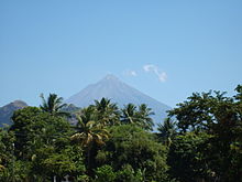
The Pacific Lowlands is a region in Guatemala. It consists of the rolling foothills of the Sierra Madre, extending across the wide Pacific plain to beautiful beaches, stretching from the Mexican border in the west to the border of El Salvador in the east. Land use is divided between cattle ranching and sugar plantations across the plain itself, with coffee and rubber plantations at differing altitudes in the foothills. The climate is hot, with the rain season lasting from May to October, including raging lightning storms and torrential downpours.
Regions
[edit]
The Pacific Lowlands consist of, from west to east, the southernmost portions of the departments of San Marcos and Quetzaltenango, the entire departments of Retalhuleu, Suchitepéquez, and Escuintla, and the southernmost portions of Santa Rosa and Jutiapa.
Cities
[edit]Other destinations
[edit]- 1 Monterrico - The beach closest to Guatemala City and Antigua, volcanic sand. The mangrove swamps separating it from the mainland are a beautiful nature reserve.
- 2 El Paredón - A coastal village popular among surfers and backpackers
Understand
[edit]
The Pacific Lowlands had a long history of pre-Columbian occupation, with major cities developing across the plain on what was a major Mesoamerican trade route. The Spanish conquest was swift in the west, which was territory dominated by the highland K'iche' Maya, but the city states of the Pipil and Xinca in the east were not politically unified, and required more sustained effort. Old world diseases eradicated much of the lowland population, opening the way to Spanish settlers and resulting in the predominantly hispanic culture of the lowlands. After independence in the early 19th century there was further influx from Europe with the establishment of major plantations for the production of sugar, coffee, and other products.
Talk
[edit]Spanish is used throughout the Pacific Lowlands.
Get in
[edit]Buses from Guatemala City to Escuintla, or from Quetzaltenango to Retalhuleu. If crossing the Mexican border from Tapachula, you are likely to end up in Malacatán.
Get around
[edit]The CA2 highway runs the length of the Pacific plain, from border to border. Lengthy traffic jams are common, especially between Coatepeque and Escuintla, and it is not unusual to spend 2 hours at a time sat in sweltering heat, only for the traffic to clear with no sign of why it was held up in the first place - usually due to accidents involving heavily laden sugar-cane lorries. There are four main routes northwards into the highlands:
- Malacatán to San Marcos
- Retalhuleu to Quetzaltenango
- Cocales to Lake Atitlán
- Escuintla to Guatemala City
See
[edit]
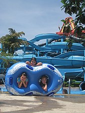
The main attractions of this region are the many beautiful Pacific beaches, and pre-Columbian archaeological remains, with the ruins of Takalik Abaj in the west, and a cluster of sculpture around Santa Lucía Cotzumalguapa, in the centre. There are also well-developed twin theme parks (Xetulul and Xocomil) near Retalhuleu in the west. In the east, there is the Auto Safari Chapín safari park.
Itineraries
[edit]If coming from Antigua Guatemala or Guatemala City, head for Monterrico for the beach and mangrove reserve, head west with a stop over at Santa Lucía Cotzumalguapa if you have an interest in prehispanic civilizations, from there you can either head up into the Western Highlands at Lake Atitlán, or continue west to the beaches at Champerico and Tulate, and the archaeological park of Takalik Abaj, all reachable from Retalhuleu. From Retalhuleu you can then head back up into the highlands for Quetzaltenango, and return to Guatemala City via that route.
Do
[edit]
- Spend time on the beach, at Monterrico, Tulate or Champerico.
- Visit the twin IRTRA theme parks (Xocomil and Xetulul) near Retalhuleu.
- Visit the archaeological park at Takalik Abaj, near Retalhuleu
- Take in the various collections of prehispanic sculpture around Santa Lucía Cotzumalguapa
Eat
[edit]At the beach, eat seafood, especially fried fish, and fresh prawns. Taxisco is famous for its cheese.
Drink
[edit]Coconuts are available almost everywhere. Avoid ice when purchasing drinks, even in chain restaurants, unless you want a dose of amoebas. Zacapa Rum is distilled in Retalhuleu, although it is aged in the highlands.
Stay safe
[edit]As with anywhere else in Guatemala, use common sense and be aware of your surroundings, especially after dark. Opportunistic theft is common. Try not to wander off alone on the beaches - mugging or rape is a real danger. Also be aware that the Pacific beaches often have rip currents and a strong undertow, resulting in tourist drownings every year, even of experienced swimmers.
Go next
[edit]- The Central Highlands around Guatemala City and Antigua Guatemala
- The Western Highlands around Quetzaltenango or Lake Atitlán
- Across the western border to Tapachula, in Chiapas, Mexico.
- Across the eastern border to Santa Ana, in El Salvador.


