{{subst:PAGENAME}} is an itinerary in Region name.
Understand
Prepare
Get in
Go/Walk/Drive/...
Stay safe
Go next
- This article is an itinerary.
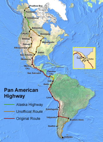
The Pan-American Highway is a series of routes that passes through Mexico, Guatemala, El Salvador, Honduras, Nicaragua, Costa Rica and Panama in North America, and Colombia, Ecuador, Peru and Chile in South America. It is listed in the Guinness Book of World Records as the longest motorable road in the world. While it doesn't officially have a route through the U.S. and Canada, some people start in Alaska and drive/bike to Ushuaia, Argentina, the southernmost tip of South America. It is necessary to bypass the Darién Gap between Panama and Colombia by ferry, however.
Understand
The Pan-American Highway is about 30,000 miles (48,000 km) long depending on the route you take. There are many options in the United States, Canada, and Mexico because of the large area and number of roads. Central America has only a few roads going north to south, with most of them - especially the Pan-American highway running along the Western (Pacific) shore.
Prepare
- See also: travel in developing countries
The Pan-American Highway passes through many diverse climates and ecological types, from dense jungles, to arid deserts, some of which are passable only during the dry season, and in many regions driving is occasionally hazardous.
Get around
There are several modes of travel that are used on the Pan-American Highway.
By bus
It is possible to use buses down all the way to Argentina, except for the Darien Gap.
By car
If you drive by personal vehicle, it is important to know that your vehicle must be shipped from Central to South America (or vice versa) in order to travel around the Darien Gap. While your vehicle is shipped, you can transport yourself by plane or boat. Driving the Pan-American Highway is certainly possible, and many travelers complete the overland journey from North America to South America (or vice versa) each year.
By bike
While most of the territory the Pan-American highway passes through cannot considered "bike-friendly" by any stretch of the imagination, every year countless people do successfully travel all or part of the route by bike.
Stay safe
Try to avoid areas where cartels operate. Follow the advice for the area you are at.
