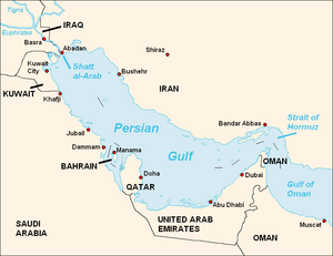
The Persian Gulf is located in the Middle East between Iran and the Arabian Peninsula. It is an extension of the Indian Ocean. The narrows at its mouth is the Straits of Hormuz, a strategically important area in various conflicts.
"Persian Gulf" has been the usual term in English for centuries; this goes back at least to the Romans calling it "Sinus Persicus". It is sometimes also called the "Arabian Gulf", mainly in Arab countries.
The entire east coast of the Gulf is in Iran, formerly known as Persia. We have an article for the Iranian coastal region.
The west coast is shared by a number of countries. Saudi Arabia has most of it, and we have an article for the Saudi Gulf coast. The other countries, listed north-to-south, are:
The Gulf Cooperation Council has Saudi Arabia, Bahrain, Kuwait, Oman, Qatar, and the United Arab Emirates as members. Nationals of any of these countries can work and reside in the others without a visa.

