
Staples

Staples is in Northwestern Minnesota.
Understand
[edit]Get in
[edit]
Map of Staples
By car
[edit]US Highway 10, Minnesota Highway 210.
By train
[edit]- See also: Rail travel in the United States
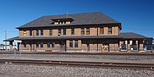
Staples Depot

- 1 Staples station, 1st Ave NE and 4th St NE. Station hours 12:45AM-4:30AM daily.


- Amtrak, ☏ +1 215-856-7924, toll-free: +1-800-872-7245. Operates train service around the United States of America. Route stopping at Staples:
- Empire Builder operating daily between Seattle/Portland and Chicago including stops at Spokane, Glacier National Park, Fargo, Saint Paul, and Milwaukee. The trains split into separate branches between Seattle and Spokane, and between Portland and Spokane, while operating as trains consisting of train cars from both branches between Spokane and Chicago.
- Amtrak, ☏ +1 215-856-7924, toll-free: +1-800-872-7245. Operates train service around the United States of America.
Get around
[edit]See
[edit]Do
[edit]- 1 Staples Cinema, 204 4th St NE, ☏ +1 218 894-3818.
Buy
[edit]Eat
[edit]- 1 Spot Cafe, 116 2nd Ave NW, ☏ +1 218 894-9928. M-Th 6AM-7PM, F-Sa 6AM-8PM, Su 7AM-2PM.
- 2 Tower Pizza, 414 2nd Ave NE, ☏ +1 218 894-3299. M-Th 11AM-9PM, F-Sa 11AM-10PM, Su 4PM-9PM.
- Wahoo Valley Bar & Grill, 19680 Wahoo Valley Dr (12 miles north of town), ☏ +1 218 894-1691.
Drink
[edit]Sleep
[edit]- 1 Landmark Inn, 631 3rd Ave NE, ☏ +1 218 894-4444. An inn located in a former church building.
Connect
[edit]Go next
[edit]| Routes through Staples |
| Fargo ← Detroit Lakes ← | W |
→ St. Cloud → St. Paul |
| Fargo ← Wadena ← | W |
→ Little Falls → St. Paul |
| Fergus Falls ← Jct N |
W |
→ Brainerd → Duluth |