
Talk:Quebec/Driving
Add topicPanoramic routes
[edit]By taking these routes you will discover a host of picturesque towns and villages bordering majestic rivers and dotting the vast expanses of forest. You will be treated to some magnificent panoramic views.
Here are a few of them:
- Montréal-Québec City: This section of highway 138, also called the King’s Road, runs along the St. Lawrence River from Repentigny to Cap-Rouge, passing by some of the most delightful historic towns in Québec. A small section of this route, Avenue Royale, extends into the municipality of Beauport, east of Québec City, where you can see homes dating back to the French colonization.
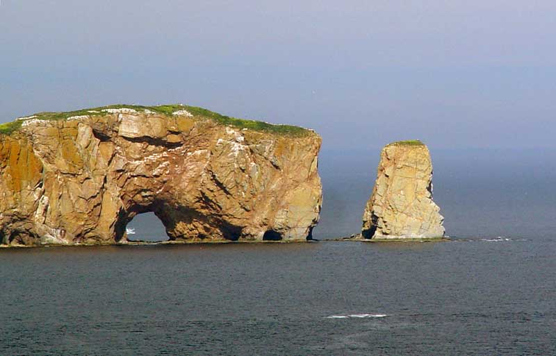
- Tour of the Gaspésie region: Highway 132 loops around the Gaspé Peninsula. It’s best to start this tour from the southern part (Chaleur Bay) and come back along the South Shore of the St. Lawrence River. The route features increasingly spectacular scenery including the famous Percé Rock.
- Québec City-Sept-Îles: Highway 138 east crosses the Charlevoix , Manicouagan and Duplessis regions. This breathtaking route is winding and mountainous so be careful!
- Trois-Rivières-La Tuque: Highway 155 north runs along the Rivière Saint-Maurice, one of the most used waterways during log-driving times.
- Eastern Townships: From Granby to Sherbrooke, highway 10 provides attractive scenery through the north-west section of the Appalachians.
For those who enjoy winding their way along country roads, this region’s various wine routes are a must (Brome-Missisquoi, highway 104 and highway 202) . To reach the eastern part of this region, i.e. Lac Mégantic, taking highway 108 starting in Magog is worth the trip.
- Saguenay-Lac-Saint-Jean: There are five lovely forested routes you can take to reach this region. Make sure your gas tank is full and beware of moose, which frequently cross the roads in this area!
Highway 155 north passes Trois-Rivières and La Tuque and takes you directly to Lac-Saint-Jean, providing a magnificent view!
From Québec City, highway 175 north crosses the Parc national de la Jacques-Cartier and the renowned Réserve faunique des Laurentides . This sinuous, hilly forested route offers a choice of two destinations at the fork of highway 169 north: Chicoutimi or Hébertville.
From Baie-Saint-Paul, the 381 north takes you to the town of La Baie by way of the Parc national des Grands-Jardins and Lac Ha!Ha! This lesser known route takes you through one of Québec’s less travelled wilderness regions.
From Saint-Siméon, highway 170 north joins the western shore of the Saguenay Fjord and takes you along a winding wooded route to the town of La Baie.
From Tadoussac, highway 172 north runs alongside the Saguenay Fjord all the way to Chicoutimi. However, the best way to explore the Parc national du Saguenay and its fjord is to take a little cruise between Tadoussac and Chicoutimi.
Tourism Routes
[edit]- King’s Road (this historical 18th-century road connects Québec City and Montréal)
- New France Route (connecting Québec City and Cap-Tourmente, this 50-kilometre (30-mi.) route is a trip through time)
- Whale Route (Manicouagan and Duplessis)
- Navigators’ Route
- Wine Route (Eastern Townships)
- St. Lawrence Route (Charlevoix)
- Border Route (Bas-Saint-Laurent, the borders of New Brunswick and Maine)
- Agricultural tour (Southern Québec)