
Vercors

Vercors is a massif of mountains and plateaus east of the Rhône Valley, between the valleys of the rivers Drôme and Isère, in the Rhône alpes region of France.
The Vercors massif and surrounding areas are protected as a regional park (Parc Naturel Régional du Vercors in French). Some especially wild and remote places of south eastern Vercors are in a more protected area named Réserve intégrale des hauts plateaux du Vercors (Vercors high plateaus reservation).
Understand
[edit]
The mountains are a good destination for people interested in nature sports such as hiking, Nordic skiing, alpinism, and caving. It is also a good place for sight seeing, as it offers various and beautiful landscapes visible from some of the most vertiginous roads in the world. Around these mountains are more lowland regions, with sharply different climates, from the almost alpine Trièves to the rather Mediterranean Diois.
Of course, as in anywhere in France, there are local food specialities, local wines, and local cheeses.
Geology
[edit]Vercors massif (dark greens and blue on the map) is a group of limestone plateaus surrounded by 300-m (1000-ft) vertical cliffs of limestone. The transitions between the different plateaus can be of different nature: east-west oriented canyons, cliffs, or more gentle slopes. The plateaus are higher in the south eastern part of the park, with the highest point of the massif (Grand Veymont) culminating at 2341 m. in this part of the park, the massif is bordered on the east by an almost continuous cliff along tens of kilometers.
These landscapes can be explained by a three step geologic history.
- During the secondary era, the area corresponding to today's Vercors was a tropical sea, with a bottom that went deeper or shallower over time. When the bottom was deeper, clay and fine material were deposed, and became soft, easily eroded shales. When this bottom was shallow, coral reefs developed, and formed almost white, hard limestone. The two most important shallow water periods are responsible for most of today limestone cliffs: "Titonic" (Titonique) limestones date from mid-Jurassic and are found in the periphery of the massif. They make small cliffs and crests mainly visible in Trièves and Diois areas. "Urgonian" (Urgonien) limestones are the backbone of the massif, responsible for its high cliffs and plateaus, the deep and narrow canyons, and the mesa-like, even tepui-like Mont Aiguille.
- During the tertiary era, the Alps surrected, and the Vercors did with them. The compression forces in here were east–west oriented, and not very strong, creating ample north–south oriented folds with a square section, and some faulting. These folds and faults are responsible for the general east–west alternance of plateaus altitudes, especially in the southern parts of the massif.
- At last, the erosion that occurred since the Vercors emerged is responsible for the cliffs and canyons we see today. All the cirques and canyons are due to water erosion, as almost no glacier developed in these mountains during the quaternary glaciations. A lot of karstic erosion, that is chemical erosion of the limestone by water, is visible in Vercors. This form of erosion not only engendered cliffs, cirques and canyons, but also a lot of caves, sinkholes (local name:scialet, pronounce "see-ah-leh"), closed depressions (French: doline, pronounce "dolin"), and dry valleys. In some places, the limestone outcrops take strange forms named lappiaz (pronounce: lah-pee-ah).
Landscapes, regions in the park
[edit]Before the end of nineteen century, the different parts of the Vercors massif where isolated from each other, and only communicated with the surrounding plains. The canyons that cut the massif, which are today some of the main communication axes, where impassable obstacles. Thus, today's Vercors was divided in at least three units: the part of the massif that communicated with Grenoble through the Furon valley (Quatre montagnes), the part that communicated with Royan (Coulmes), and what was called the Vercors, which was linked with the Drôme valley. This last part, the largest, is split in two halves, the western plateaus, more humanized, and the high plateaus, more high and wild.
- The Coulmes area, in the north west of the massif, always was and still is the most forested area of the massif. The forest was exploited for coal making in the 19th century, especially by people coming from Italy, thus giving to Vercors one of its culinary speciality the ravioles which are some kind of ravioli (See the section "eat"). It also is an area where the Vercors looks more like a mountain and less like a series of plateaus, the urgonian folds being more rounded compared with western, northern and high plateaus. The coulmes can be reached through several quite impressive roads, especially the Nant gorges road, and the Ecouges road, both directly dug in the cliffs.
- The Northern Plateaus of Vercors are also named the "Quatre Montagnes" that can be literally translated in "the four mountains" but rather means something like "the four villages/communities/cultivated areas in the mountains". This area is today the most developed area of Vercors for tourism, especially Nordic and alpine skiing. It is a nice weekend sport destination for the Grenoble citizens. Nevertheless, traditional activities still exists there, mainly based on cattle breeding and cheese making. The four main villages of the area are reparted on two plateaus separated by a north–south forested mountain. Autrans, Méaudre, Lans and Villard de Lans both are ski resorts and host farms. This website (In French...) presents some very nice pictures of the northern Vercors massif, and the area surrounding Grenoble.

- The Western plateaus (Vercors Drômois) are more numerous but smaller. Together with the high plateaus, they are what was first named "Vercors", before it became the name of the whole massif. Some of these plateaus are self evident (Plateau d’Ambel, Font d’Urle), but other where dismounted by erosion (Glandasse, l'Echarasson...). From these areas, spectacular vistas can be seen of the surrounding plains and other mountains. In the north of this area, several deep canyons are present. These canyon are traversed by very impressive roads, directly dug in the cliffs.
- Traditionally, the meadows of the west plateaus and the high plateaus are used as pasture in summer, according to the millennia-old practice of estive (pronounced "ess-teev") or transumance (pronounced "tranz-humans"). The sheep are moved from the mountains to the plains and back every year: In winter, they graze in the plains where the temperatures are warm and the grass still green (while in mountains it is buried under heavy snow), and in summer, they are brought to the mountains where the grass and the air are fresher than in the plains.

- The high plateaus natural reservation is the highest, wildest and most protected area of the park. It contains no human permanent presence, no paved road, and no vehicle is authorized. The only economic activities are logging and sheep breeding (see "estive"). These traditional activities continue to exist because they are essential for the delicate ecological equilibrium of the high plateaus. Logging especially is not made by blank cuts of whole areas, but using the old method of the futaie jardinée (gardened forest) where a few trees are cut each few year, preventing the forest from invading the pastures and from degenerating by overaging.
The surrounding areas around the massif that are part of the natural park (light and yellowish green on the map) can be cut in four main parts:
- The Royans, in the northwest, is an area of hills dedicated to cattle breeding and walnut growing. Three of the impressive vercors gorges converge toward this area: Combe Laval, the Grand Goulets and the Bourne gorge.
- The Gervanne, in the south west, is an area of Piedmont slopes with nice villages.
- The Diois, in the south, corresponds to a part of the Drôme valley centered on the town of Die. This area has a clear Mediterranean accent, with lavender fields and vineyards producing a sparkling wine, the Clairette.
- The Trièves, in the east, is a low hilly plateau below the high summits of Veymont and the gorges of the Drac river. On the west of this area is one of the rare mesas existing in France, the Mont Aiguille ("needle mountain")
As everywhere in Europe, humans have greatly influenced the landscape. Today, Vercors Regional Park is inhabited by 32,000 permanent residents living in either lonely farms or in one of the more than 20 towns and villages that exist within the park.
History
[edit]The name "Vercors" given to this massif comes from the "Vertacomicorii" a celtinc tribe living in this area when it was invaded by the Romans. During the roman rule, human occupation of this massif was limited to the surrounding slopes, principally in the Diois area. The plateaus where used only seasonally, for examples as a source of building stones (quarries in the high plateaus)
During the Middle Ages, permanent dwelling and villages progressively appeared, starting in the 11th century. Middle Ages settlements started in the villages of la Chapelle, Saint Julien, Saint Martin and Saint Agnan, in what was called the "Vercors valley".
During the 18th century, the forest started to be exploited as one of the most valuable assets of the plateaus. One of the traces of those times is the name of the vertiginous pass at the bottom of the Combe Laval gorge, le col de la machine, i.e. the pass of the machine. That "machine" was a kind of crane used to lower the logs from the Vercors plateau down the then impassable 300-m high cliffs.
Wood production from the thick forests of the Vercors was also very important in the 19th century. By the end of that century, several roads, among the most vertiginous in the world, were dug in the cliffs of the Vercors primarily for wood transportation. Although intensive, and perhaps sometimes excessive, wood exploitation was not destructive, since the most important forest of those times (Lente, Coulmes) are still prosperous today. This is partly due to the long term management plans used in state forests (Foret domaniales) in France since the 17th century.
During the 20th century, these mountains were used as a natural fort by the French Resistance during World War II. These resistant camps housed 400 combatants by the beginning of 1944, provisioned by locals who were mostly friendly. On June 6, 1944, the roads entering the mountain were closed, and the Vercors was declared a republic (République du Vercors). On July 21, 1944, the mountain was attacked by 15,000 German soldiers by the roads, the small passes in the cliffs, and from the air. There are only 3,500 Resistance fighters. 600 Resistance fighters and 200 civilians including women, children and infants, were killed, most in gruesome ways. The killing of civilians was especially horrible in the village of Vassieux, where SS troops killed all the inhabitants and destroyed the houses.
A lot of competitions of the Winter Olympic games of 1968 (Grenoble) took place in the northern part of the park, especially in the villages of Villars de Lans, Saint Nizier du Moucherotte and Autrans.
Flora and fauna
[edit]Vercors is populated by both hills animals like stag (cerf), roe deer (chevreuil), common hare (lièvre), and wild boar (sanglier); and mountains animals like ibex (bouquetin), chamois (same spelling), marmots (marmotte) and variable hare (lièvre variable). Some Corsican mouflons (mouflon) have been introduced. Nevertheless, American visitors have to expect animals, and especially large mammals to be much shyer than in the American continent.
There also are a lot of bird species, due to the large diversity of biotopes in Vercors. The French chocard.com website[dead link] presents the 140 bird species found in the Vercors Regional Park, with a description and a repartition map for each species.
Flora is also a mix between the alpine flora and what is found down in the plains. Among the alpine species, 28 rare or endangered species are visible, including the wild tulips, lady slippers orchids and edelweiss. More common species adorn the woodlands and meadows, such as great gentian (grande gentianne), alpine gentian (Gentiane des alpes), alpine linaria (linaire des alpes), saxifrage (same spelling) and narcissus (narcisse).
Get in
[edit]By car
[edit]Vercors Regional Park is accessible by car from main surrounding cities for day trips or longer vacations. Park entrance is within a 10-minute drive of these four cities:
- From Grenoble the main route is through the Furon gorge (D531 south, direction Lans-en-Vercors).
- From Romans, take the N532 to the northeast, in the Isere valley, to the town of Saint Nazaire en Royans. From there, take either the D76 or D531 to the east.
- From Valence, reach Romans first, using the N532, or directly enter the park taking the D68 east through the passes of Col des Limouches, or the D171 east to Alixan and then D101 through the perhaps more picturesque Tourniol pass.
- Die (pronounce “Dee”) is inside the regional park. It can be reached from Valence through the D93. From Die, the Vercors plateaus themselves can be reached by climbing the Rousset (pronounce “roo-say”) Pass (Col du Rousset) on the D518 heading north.
- Be aware that, because of the cliffs surrounding the high plateaus, there is no road access to Vercors mountains from the east between Grenoble and the Rousset pass. The Trièves area of the park is traversed by the N75 and the beginning of A51. To link this area with other parts of the park by car, one has to reach either Grenoble through the N75 (north) and the A51 or Die through the Grimone pass (D539, west).
Here is how to reach Vercors from farther away:
- From Nice, the French Riviera and Liguria, two ways are possible
- Through the interstates system: go to A8 (A10 in Italy) heading west, until Aix-en-Provence, and then the A7 heading north toward Valence. this is a 3- to 4-hr trip.
- If you have more time (at least 5 hr), go to Canne, and from there reach Sisteron through the very nice N85 (Route Napoléon) heading north. After Sisteron, take the N75 north until you reach the small town of Aspres. You then can either reach Die using the D993 heading west through the Col de Cabre pass, or Grenoble staying on the N75 heading north. If you do so, you will enter the Trièves area of the regional park before arriving in Grenoble.
- From Paris (and Lyon): From Paris, take the A6 heading south-southeast until you reach the city of Lyon (6 hr driving). Then, take the A46 that goes around Lyon to the south east, then the A43 until Bourgoin-Jallieu, then the A48 from there to Grenoble. (45 minutes).
- From Spain: Leave Spain through the Col du Pertus pass, the large interstate through the frontier at the east of the pyreneans (AP7 in Spain, A9 in France). Stay on the A9 until you reach Orange. There, change interstate to take the A7 north until you reach Valence. This is a 4-hour trip from the Spain border to Valence.
- From Italy:
- Except for the Aosta valley and the Liguria, the shortest way to Vercors is through the Col de Montgenevre pass (SS24 in Italy, N94 in France) near the Fréjus tunnel (A32 in Italy). Go east along the N94 until Briancon, then take the N91 west through the Galibier pass until you reach Vizille. In this city, take the N85 north west to Grenoble.
- If you do not want to leave the highway system, go through the Fréjus tunnel (A32 in Italy, A43 in France), then continue north west on the A43 until you reach Montmelian, a little distance before the larger city of Chambéry. In there, take the A41 south west to Grenoble.
- From the Aosta valley, the shortest way is through the Col du Petit Saint Bernard pass. (S26 in Italy, N90 in France). Stay on the N90 until you reach the A430 in Alberville. Continue until the end of the interstate, and then take the A43 to the south west. The route is then the same as from the rest of Italy through highway.
- From Swizerland (and Annecy): Leave Genève on the N201 heading south to Annecy. In Annecy, Go on the A41 heading south to Aix Les Bains, Chambéry, and then Grenoble.
By train or plane
[edit]The largest train stations around Vercors are Valence TGV, Downtown Valence (Valence Ville) and Grenoble.
- In Valence TGV comes from Lyon, Lille, Paris, Montpellier, Nantes and Marseille everyday. In certain periods, there are Thalys trains coming from Amsterdam, Anvers and Brussels.
- In Valence Ville arrive trains from Nice and the Riviera, Briançon, Gap, Lausane, Geneva, and buses from Privas and Aubenas in Ardèche.
- In Grenoble arrive TGV trains from Paris, Geneva, Lausanne, Chambéry, and trains from Gap, Dignes, and Italy (Torino, Milan, Venice)
Some small train stations are w in the park:
- The station of Die receives 3 trains daily in each direction on the line Valence-Gap.
- The stations of Clelles and Saint Michel des Portes receive 6 trains daily on the line Grenoble-Gap.
The nearest international airport is Grenoble Isère International Airport [formerly dead link] , about 40 km from Grenoble, or about 35 minutes by coach. This is a small airport although flights are more frequent in the ski season.
Also, about 100 km from Grenoble, the Saint Exupery (Satolas) Airport in Lyon. From this airport, it is possible to commute to Grenoble and Valence by TGV (30 minutes). airlines link Satolas airport with the other French international airport (Orly, Roissy, Toulouse, Nice), most of EU countries, middle east (Turkey, Israel), northern Africa (Algeria, Morocco, Egypt), Canada, and the French territories oversea (Réunion, Guadeloupe).
The Paris Charles de Gaulle airport, although farther away, can be convenient, as it is directly linked with Valence (2½ hours) and Grenoble by TGV (3 hours), and has connections worldwide.
By bus
[edit]Vercors can be reached by bus from the three largest surrounding cities, Grenoble, Valence and Die.
- From Grenoble, three regular bus lines exist:
- From Grenoble to the ski resorts of northern vercors (Autrans, Corrençon, Lans en Vercos, Méaudre, Saint Nizier, Villars de Lans)
- From Grenoble to the villages of Royans: Saint Jean, Saint Laurent, Sainte Eulalie and Pont en Royans.
- From Grenoble to the Trievre: Gresse, Clelles.
These lines are operated by the VFD company. Telephone (From France) 0820 833 833, e-mail: allo.VFD@VFD.fr, Website in French
- From Valence, four regular bus lines exist:
- To Die (Line 28) (it also is possible to reach this city from Valence by train)
- To Combovin (line 7, 2 busses per day)
- To Beaufort sur Gervanne and Plan de Baix (Line 25, 1 round trip per day)
- To The Royans villages (the same ones than from Grenoble, Line 5, 7 round trips per day). Some busses from this line (one or two per week) continue to the villages of the western plateaus: La Chapelle, Vassieux, Saint Agnan and Saint Martin en Vercors.
- From Die, one bus line (Line 29, one bus every two hours) leads to several villages of the Diois area of Vercors Regional Park, including Châtillon en Diois.
Lines from Valence and Die are operated by the authority of the Drôme département (Conseil Général de la Drôme or CG26). Telephone: +33 4 75 81 72 62, Website in French [dead link]. It is also possible to benefit from personal transportation services (services de rabatement), that is transportation from one place in the western Vercors to the nearest bus station in the surrounding plains. Reservation has to be made in advance for such services, generally in the local chamber of commerce (Office du tourisme).
Fees and permits
[edit]As always with National or Regional Parks in France, there are no entrance fees, and in fact the entrance itself will not be easily located along the road. Only a small signpost generally marks it.
Get around
[edit]Common modes of transportation are scarce inside the park, and it is wise to have an independent mode of transportation such as a car or a motorbike. Bicycle can also be used, but the long slopes of the different passes in the park are only accessible to trained people. Roads in and around Vercors are sloping, curvy and narrow mountain roads. Nevertheless, almost all roads are paved, and they are well maintained.

Four main roads cross the plateau, in a general north–south direction: The D531 highway, starting from Grenoble, enters the Vercors Regional Park through the Furon gorges heading south. It reaches Lans en Vercors and Villards de Lans, and then turns west, entering the Bourne valley. Progressively, this valley become a deeper and narrower gorge. Eventually, after very impressive narrows, the road reaches out of the gorge, and arrives at Pont en royans. Heading a south-west direction, the roads leaves the Park a little bit before Saint Nazaire en royans, where it reaches the main highway to Romans.
The D76 highway starts from Saint Nazaire en Royans, and heads south east until Saint Jean en Royan, inside the park. From there, the road climbs on the plateau through the very impressive road of Combe Laval. After the Col de la Machine pass, the road heads south east to Vassieux en Vercors, and then the Rousset Pass.

There is a link between the D531 and the Rousset pass that do not climb down the plateau. It starts in the bourne gorges with the name D101, changes its name into D518 in Les Barraques en Vercors, and then heads south through La chapelle en Vercors and Saint Agnan en Vercors until it reaches the Rousset pass. After it, the road continue southward and downwards until it reaches Die.
The D199 highway heads west from the Col de la Machine to the col de la bataille and Léoncel. It then changes its name in D68 and continues westward to the plains surrounding Valence through the Col des Limouches pass.
The Gervane area is crossed by the small (but paved) D70 road that links the col des limouches with the Drome valley through the Col de Bacchus.
The Diois area is crossed by the large D93 highway. This highway and the D518 from the Rousset pass meet inside Die.
The Trièves is crossed by the N75. It is not possible to go by car from this region to the Vercors plateaus without living the park first.
There are many other roads in the park that links all the small villages with the surrounding plains, including Col de la Croix (Pass of the Cross), Gorges du Nant, Col du mont noir (Pass of the Black Mount), and Col de Romeyere. The road of the Grand Goulets (D518) is closed because of a major landslide. Roadwork is ongoing to reopen the road through a tunnel. The gorge road is planned to be reopened for pedestrian and bicycles only.
A road reform is ongoing in France and road numbers are changing. Generally speaking, it is better to follow directions from village to village rather than trying to stick to road number that are written small and more difficult to follow. Impressive parts of the Vercors roads (Combe laval, Nant gorges, etc.) are generally well indicated and easy to find.
See
[edit]
Natural features
[edit]- The vertigo roads (Les routes du vertige) of the Vercors gorges, especially Combe laval (D76), Les Grands goulets (The Great Gullies) (D518), the Nant Gorges (Gorges du Nant) (D22), and the Ecouges gorge (gorges des Ecouges).
- The Bronzed Fir (Sapin Bronzé), an exceptionally large and old fir tree in the Lente forest.
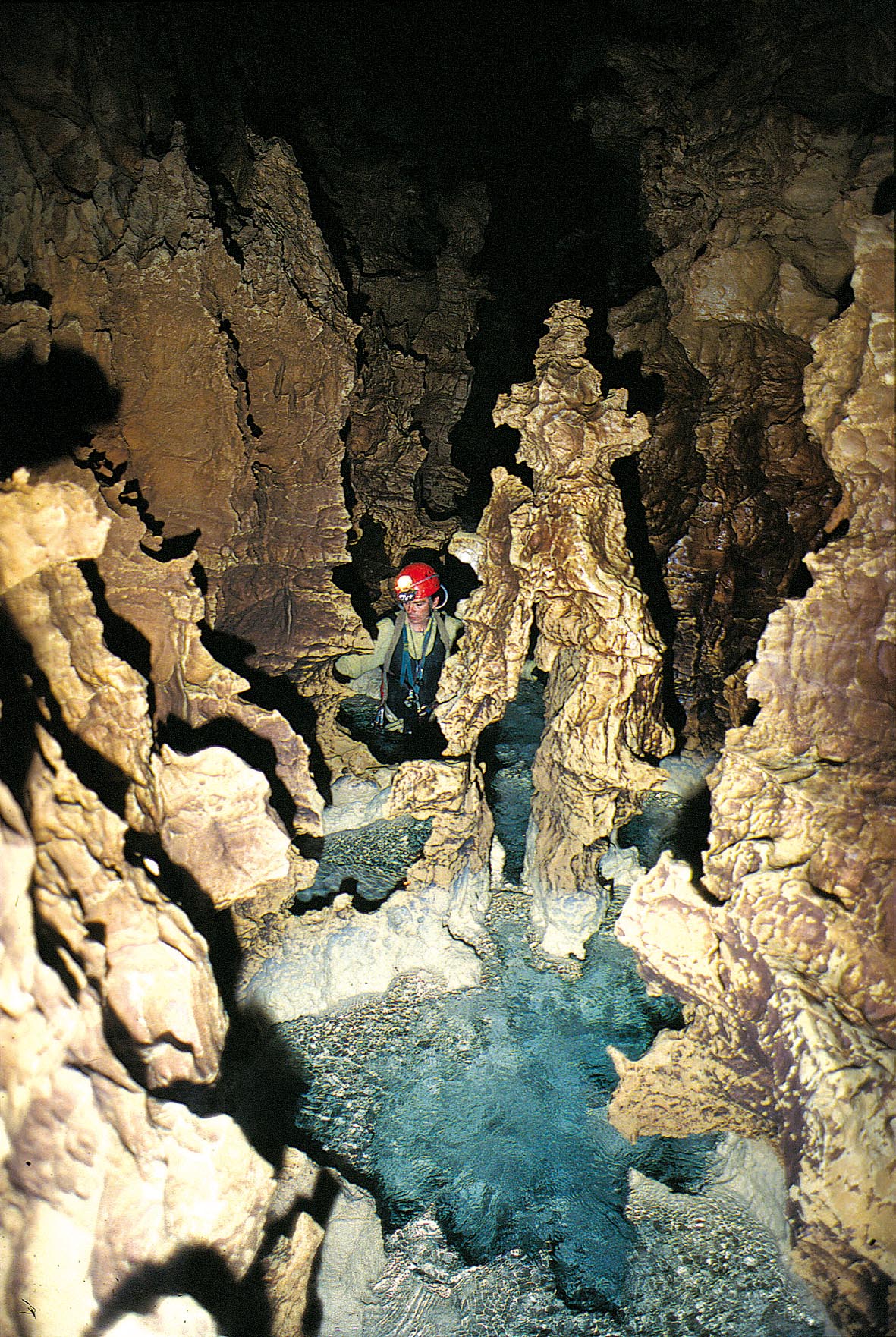
- Caves (Grottes, pronounced "grot"): The Vercors massif is crossed by a large number of caves. Some of them are equipped and can be visited without any training.
- Choranche caves (Grottes de Choranche). The, near Pont-en-royans, show rare and impressive speleothems.
- Grotte du Thaïs (pronounce "tice") near Saint Nazaire en Royans. Nice concretions are visible together with prehistoric paintings. Full price €6.5, Tel.: +33 4 75 48 45 76
- Grotte de la Draille Blanche near La Chapelle en Vercors. The cave shows rare fossils of animals of the ice age, and zoo can be visited after the cave. Full price €6. Tel.: +33 4 75 48 24 96
- Grotte de la Luire near Saint Agnan en Vercors shows large volumes, and an impressive pit. Full price €5 tel: +33 4 75 48 25 93
Artifacts, history
[edit]
- Resistance Memorial (mémorial de la Résistance), ☏ +33 4 75 48 26 00. The in Vassieux-en-Vercors. (website in French)
- The 13th-century chapel in the village of La Chapelle en Vercors
- The 13th-century abbey in Léoncel
- The village of Pont-en-Royans and its impressive houses overhanging the Bourne river.
- The picturesque village of Saint Nazaire en Royans under its 35-m high 19th-century acqueduct. The acqueduct is still used to carry water, but can also be visited.
- The old city of Die, its romanesque church and city walls were made in the middle age with blocks from Roman monuments.
- The village of Chichiliane in the Trièves area is a nice old village, and offers splendid views of the Mont Aiguille.
- The village of Archianne in the same named cirque (eastern Diois area).
- The village of Sainte Croix and its old monastery, the church split into two parts a catholic and a Protestant part and its vineyards.(website in French) [formerly dead link]
Do
[edit]Hiking
[edit]Hiking paths are clearly marked and well maintained. For more information visit the local tourist information offices. They can help you with selecting the hikes suited for your condition, experience or group composition. They also sell detailed hiking maps (€7) and have an up to date weather forecast.
Here is a small selection among the thousand possible hikes in and around the Vercors massif.

- From the surrounding areas:
- The Archiane cirque is a nice place for those who do not fear vertigo. There are two hikes: One climbs in the bottom of the cirque to the "plaine du roi" in the high plateau, another stays inside the cirque. In fact, this is the vertiginous one, as most of the hike is on a small flat balcony in the middle of the cliff!
- The Mont Aiguille (“Needle Mountain”) is a very small plateau surrounded by sheer cliffs. It is possible to hike around it in one day from the village of Chichiliane in the Trièves.
- The Pas de l'aiguille (needle pass, pas being often used in toponimy instead of col for a pass with no road) is a pass through the cliffs from the Trièves to the High Plateaus, with beautiful views of the Mont Aiguille.
- In the western plateau:
- Plateau d'Ambel, from the Col de la Bataille Pass (1340m) a nice day hike around the cliffs bordering the plateau.
- Plateau de Font d'Urle From the ski resort of Font d'Urle, a view to the porte d'hurle, one of the small entries in Vercors through the cliffs, and a nice walk along the top of the cliffs bordering the plateau. A lot of wild flowers in spring, and a large variety of karst formations.

- The northern plateaus (Quatre montagnes) are more economically developed, especially with larger ski resorts. Nevertheless, there are still nice wild place to visit... by feet:
- Bec de l’orient, 1554m. A nice view of the Isere valley after 1h of climbing.
- Moucherotte. 1 901 m, a 6h hike, gives nice views of the city of Grenoble.
- 1 Grande Moucherolle. 2 284 m

- The High Plateaus Reserve (Réserve naturelle des Hauts Plateaux du Vercors) is only accessible by feet. It is a rare landscape of almost true wilderness in the heart of Europe. Several hikes are possible in this area:
- The Grand Veymont, 2 341 m (highest point of Vercors) the hike needs a full day.
- The roman quarries (les carrières romaines). A nice hiking goal, either from the east or the west. They need a whole day hike. The quarries themselves are littered with old column stumps that were not nice enough to be transported down to Die.
Nordic skiing
[edit]One of the largest Nordic skiing system of Europe is available in Vercors. In the core of the winter season, it is possible to link Saint Nizier, at the northern tip of the plateaus, to the Rousset pass that mark the southern limit of the massif.
The largest Nordic skiing stations of Villard de lans-Corrençon and Autrans have an international reputation as several hundred of kilometers tracks are accessible from each of these stations. Other Nordic skiing stations include:
- Les Coulmes
- Saint Nizier
- Fond D'Urle
Every year, two Nordic skiing races are organized:
- In January, the Foulée Blanche around Autrans, gather a lot of local Nordic skiers. Several races of several length are proposed, allowing everybody, including children, to participate. The longest race, of 40 km, must be in good physical condition.
- In March, the Grande Traversée du Vercors (GTV, for Great Vercors Crossing) is organized between Vassieux and Villard de Lans. Unlike the "Foulée Blanche", this race is reserved to highly trained peoples.
Alpine skiing
[edit]Several ski resorts exist in Vercors Regional Park.
- Villard de Lans (the largest - Website in English [dead link])
- Autrans (website in English[dead link])
- Gresse en Vercors (Website in English)
- Le col du Rousset
- Font d'Urle / Chaud Clapier
- Lans en Vercors (Website in French[dead link])
- Autrans/Méaudre (Website in French [dead link])
Paragliding
[edit]The Vercors mountains, with their plateaus surrounded by cliffs, are especially conductive for Paragliding (Parapente). Several launching areas are available around Lans and Villard de Lans. (Website in French of a commercial paragliding school)
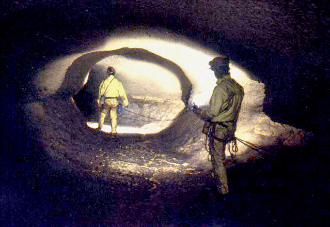
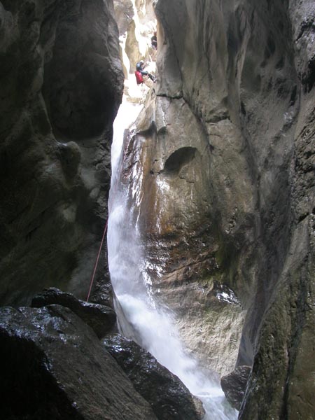
Canyoning and caving
[edit]Being a karst mountain, Vercors is rich in caves (grottes) and deep, narrow canyons. The best known caves for speleologist in Vercors are:
- Grotte de la luire. With its pure shaped tubes.
- grotte de gournier.
- Le trou qui souffle.
- 2 Le gouffre Berger. One of the deepest caves in the world.

- 3 Grottes du Bournillon.
Some of the canyons of Vercors:
- Gorge des ecouges. In the Coulmes, a very nice, but rather hard canyon.
- Canyon du Furon. An easy canyon.
- Canyon of Léoncel. In the Royans.
- Les trois blaireaux. Not really a canyon, but a single large cascade.
- Rio Sourd. A very nice canyon at the southeastern tip of the park, in Diois.
- Canyon des Moules Marinières. In South Vercors
Locals generally do caving (spéléologie or spéléo) and canyoning (descente de canyon) outside of structures, or in small not-for-profit club structures that are not easily accessible for foreigners visiting the place for a short time. Nevertheless, it is possible to practice this activity at any level for anybody.
Trained caver or canyoners who want to share their passion with locals can contact local clubs for conjoint explorations. Members of local clubs will generally propose guiding, or participation in upcoming explorations, and can lend spelunking gear. The cost will be limited to a yearly inscription fee that includes specific insurance coverage. In this kind of structure, be aware that people will not provide you a service for a fixed price, but will share with you some of their leisure time. The fee you pay is not for them (and in fact, they also paid it), but for the insurance and the non-profit structure.
People interested in initiation in caving or canyoning can contact the “bureau des moniteurs” (guides association). A personal guided initiation or exploration of a cave or a canyon will be proposed to them. In this structure, you can expect a more classic customer/salesman relationship. The “bureau des moniteurs” can also organize for you other sporting activities such as escalating and via ferrata.
Bureau des Moniteurs du Vercors:
15 av. des Francs-Tireurs
BP 25, C38250 Villard de Lans, CFrance
Tel.: +33 4 76 94 14 50
(Website in English [dead link])
- Canyon du Versoud. An easy canyon.
Events
[edit]Vercors Massif is not only a place of nature and traditions. The village of Autrans, in the northern plateaus, hosts every year a national festival of the Internet, the Autrans Meetings (Rencontres d'Autrans, website in French) and the mountain film festival, website in French.
Calendar & events: Have a look on Agenda on Initiatives-Vercors.fr (in french)
Eat
[edit]Local specialities
[edit]- Ravioles, a kind of very small cheese and herbs ravioli. You will easily find them as a side dish in the local restaurants, but they can also be bought, and then are very easy to cook (one minute in simmering water)
- Noix de Grenoble: Walnuts produced in the vicinity of Grenoble, including Royans, are reputed in France.
- Caillette is a finely grounded mix of green vegetable and porc offals enveloped in caul eaten cold or warm on bread. It tastes far better than it sounds. You will find caillette all over the park and also in most of the Drôme Valley, in and around Grenoble, east of Rhône around Valence, in the Isère valley and the hills surrounding it from Grenoble to Valence
- Gratin dauphinois is a typical side dish of the Rhône-Alpes region. It is made from sweat cream, milk and finely sliced potatoes. These ingredients are cooked together slowly in the oven and finally broiled on the surface.
- Cardoon (cardon). Is a vegetable eaten like Swiss chard or bog-choi but looking more like an artichoke. This vegetable is known from the Mediterranean France to the French-speaking areas of Swizerland. It is generally eaten boiled, or au gratin.
Cheeses
[edit]- The Bleu du Vercors-Sassenage is an appellation cheese produced only from cow milk produced in the Vercors plateaus. This blue cheese is sweeter and smoother than Roquefort cheese, and can be melted.
- Saint Marcelin and Saint Félicien cheeses are produced in the Isère valley between Romans and Grenoble from raw cow milk.
- Picodon is an appellation cheese made from pure raw goat milk produced in the Drôme or Ardeche départements. It is a strongly aromatic (even sometimes peppery) dry cheese with an exterior color ranging from white to blue or dark greenish grey. This chese is excellent eaten the French way, that is raw on a slice of bread after the main dish and before the dessert.
- Although handcrafted cheeses are generally the best ones, some small companies, such as L'Etoile du Vercors (Website in French [dead link]) are able to produce excellent ones.
Restaurants
[edit]- Northern plateaus:
- La Buffe, ☏ +33 4 76 94 70 70, fax: +33 4 76 95 72 48, contact@la-buffe.fr. In Autrans. Menus for kids and vegetarians available. €19-45 menus.
- Restaurant Barnier in Autrans
- In Royans
- La Table des Forges, ☏ +33 4 75 47 67 50. In St Laurent en Royans. Trouts from the nearby Cholet and ravioles.
- Les Tracols in St Laurent en Royans.
Drink
[edit]- Local liquors
- The gentian (gentianne). Gentian liquor is a bitter digestive drink obtained by macerating roots of the great yellow gentian in a mix of water, fruit alcohol and sugar. This liquor is produced in several mountainous areas of France, including Vercors. Most of the production is made at home and not sold, but now some of this liquor is available to visitors in some speciality shops specialized in local products (produits du terroir).
- The same story can be told about Walnut wine (Vin de noix) made from walnut stain (not the nut itself), alcohol, sugar and wine. Some professional producers now exist in the Royans, and this drink can be found in local shops.
- Châtillon en Diois is the only wine produced inside the natural park. The small (65 ha) area of production corresponds to the south eastern tip of the park, around the village of Châtillon. This wine is a still wine that is made in red, blush and white versions. The red and blush wines are made mainly from Gamay grapes with additions of Pinot and Syrah. The white wine comes from a mix of Aligoté and Chardonay grapes. These cultivars are generally found on northern parts of France, but here, they are well adapted to the altitude (700 m).
- Clairette and Crémant de Die are two sparkling white wines made from grapes growing around Die in the Drôme valley. Clairette is issued from a mix of "Muscat a petit grains" and "Clairette" grapes, while Crémand is only made from "Clairette" grapes.
- A bit farther from the park is the Rhône valley, with all its renowned wines, the nearest of Vercors being Cornas, Tain l'Hermitage, Croze Hermitage and Saint-Joseph.
Sleep
[edit]In Trièves (South-East of Vercors)
- [dead link] La Petite Datcha (The Small Datcha). Comfortable summer residence completely reconstructed in 2008 in Chichilianne. At the bottom of Mont Aiguille (Mount Needle), the Trièves symbol which is 2086 meters high above horizon. English, French and Russian spoken.
In Autrans (Northern plateaus):
- Hôtel la tapia**, ☏ +33 4 76 95 33 00, fax: +33 4 76 95 38 63. Small hotel (10 rooms) in the village.
- Hôtel de la poste***, ☏ +33 4 76 95 31 03, fax: +33 4 76 95 30 17, gerard.barnier@wanadoo.fr. Rooms and suites from €50 to 100.
In Royans:
- Le Castel Fleuri**, St Jean en Royans. Restaurant, swimming pool, Logis de France label.
In western plateaus:
- La Forêt**, in the hamlet of the Lente forest.
- Le Col de la Machine**, in the col de la machine pass.
In Villard de Lans:
- [dead link] La Villa Primerose, 147, avenue des Bains, 38250 Villard De Lans, ☏ +33 4 76 95 13 17. Offers very reasonably priced accommodation, a friendly welcome and features a fully equipped kitchen which may be used by guests. Great if you prefer to self-cater. €29-71.
Camping
[edit]There are various campgrounds in the Vercors. Most of them are only open in high season from 15 June till 15 September. If you are not a confident driver you also might want to check the accessibility of some campgrounds when using a mobile home or a caravan.
Stay safe
[edit]The main dangers in Vercors are in its topography. The risks of falling from cliffs must not be underestimated, and the swallow-holes are a hazard that exists everywhere in the plateau. Use extra caution if fog weather occurs, if for any reason the visibility is reduced, or if you walk away from designated path.
Some of the more scenic roads are literally dug in cliffs, in gorges, etc. These roads are narrow, with sharp bends. Exercise caution, especially in bad weather.
The Vercors plateau is at a higher altitude than neighbouring cities such as Grenoble. As such, areas in Vercors may receive snow while there is none in these surrounding cities and valleys. Main roads get snowploughed, but secondary roads might not; some secondary roads may be closed in winter, and some roads may be accessible only with tire chains. Snow tires are strongly advisable in winter, but most rental agencies do not provide them by default.
Because of the Karstic nature of this mountain, water is scarce. If hiking, always carry more water than you think you need.
If snowshoeing, especially in slopy or isolated places, carry a shovel and an ARVA apparatus, in case of an avalanche.
Although wolves have been noticed in the park, large mammals do not generally represent a risk. Do not feed them, even in the extraordinary case you are in the situation to do so. Vercors Regional Park is rabies free.
It is advised to lock cars and to avoid leaving money or valuables in them when going for a hike. Although infrequent, thefts can occur.