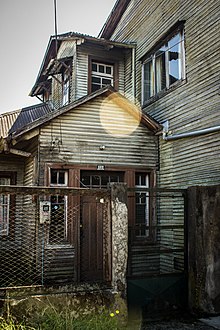
Villarrica is a town of 50,000 people (2012) in Araucanía. The wooden houses and the surnames of numerous families reflect the German and Dutch roots of the Villarrica area, which from 1850 received a large stream of European immigration.
The area has several national parks and some volcanoes.
Understand
[edit]
Tourism, grain and dairy farming, and forestry are the main economic activities of the community.
The climate is mild and humid with the greatest rainfall experienced between May and July (autumn and winter). The dry season is between December and February (summer).
Get in
[edit]Overnight buses from Santiago leave daily. Rural buses leave from the Temuco Terminal.
Or you can fly to Temuco and drive an hour to get to Villarrica.
To drive to Villarrica, you must take Route 5 South and access through the indicated detour.
Get around
[edit]Plenty of local micros to get around, but a rental car is the way to go if you want to take full advantage of the area. You can also book organized tours with the adventure tourism agencies like Politur in Villarrica to get to the summit of Volcano Villarrica, Huerquehue National Park, hot springs, rafting, riding tours, canopy and more.
See
[edit]
- Volcano Villarrica
- caves
- hot springs
- museum
- the Mapuche center
- local artesania
- araucaria trees
- woodpeckers
- Villarrica Lake
Do
[edit]- 1 Huerquehue National Park. Hike to the summit of Volcano Villarrica, or at the base of Volcano Lanin, canopy, or rafting.
- Soak in steaming hot springs, best are Los Pozones or termas geometricas. Thanks to the numerous volcanos, hot springs nearby include Coñaripe (48 °C), San Luis (43 °C), Huife (49 °C), Palguín (57 °C) and Liquiñe (87 °C).
- Ride horses through pristine forests.
- Ride bikes to nearby towns or on pastoral roads.
- Sunbathe and swim on Lake Villarrica's beaches. In the summer, water sports and sunbathing are popular activities in the warm temperatures experienced at the low altitudes ranging from 200 to 500 m above sea level.
- Fishing and rafting are popular activities in the various rivers in the area, which include the Toltén, Voipir, Trancura, Llancahue and Lincura. Popular waterfalls include León, La China, Palguín, Ojos del Caburga.
- 2 Villarrica National Park. 63,000 hectares of araucaria, lengas and coigues forests, lagoons and caves of volcanic origin to explore and discover. Villarrica National Park is 36 km (22 mi) away, and was created to preserve the natural beauty of the volcano. The area is noted for using wood as its principal building material.
Buy
[edit]- Delicate wood carved artesania
- woven wool blankets
Eat
[edit]
- Hosteria de la Colina - delicious food, from steak to homemade pasta to creative soups and salads, followed by Glen's homemade ice cream.
- Mesa del Mar - great fish
- Cafe bar 2001 - restaurant-cafe, sandwiches, cakes and more.
- El rey del marisco - seafood.
- Sweet - Pastry and sandwiches.
Drink
[edit]- Traveller's Resto- good place to sit and enjoy a beer, dinners - for younger ones.
Sleep
[edit]- Hosteria de la Colina, Las Colinas 115- Ex-pat owners Glen and Bev make a stay here impossible to forget. Superb views, excellent food, spacious terrace and full bar and game room, spotless rooms and comfy beds.
- Hotel El ciervo. Near to the lake and town centre.
- Hotel Terraza Suite, Julio Zegers 351, ☏ +56 45 241 4508. Free breakfast and large deck for viewing volcano alongside pool. US$91.
- Cabañas Montenegro, Prat 735, ☏ +56 45 241 1371. Nice place with cabins, well located.
- Hotel El parque. Beautiful view.
Go next
[edit]- K-Zona about 5 km (3 miles) outside Villarrica in direction to Pucon. Don't go there before 14:00. Travellers' bar with good music.


