Wemotachi is one of the First Nations (Indigenous) reserves of the Atikamekw within the La Tuque Region in Mauricie, Quebec.
In Atikamekw language, "Wemotaci" means: "The mountain from which one observes". During its history, the spelling of the toponym has changed several times depending on the sources or the authors. The spelling "Wemotaci" was made official in 1997 and replaced that of "Weymontachie 23".
Understand
[edit]- See also: Indigenous cultures of North America
Geography
[edit]This Haute-Mauricie reserve is bounded on the west and south by the Saint-Maurice River. The boundary on the east side is 3.8 km (2.4 mi) long; on the north side, its boundary extends 7.8 km (4.8 mi).
From Wemotaci, the forest road along the Saint-Maurice river on the east bank leads north to the Jolie River. On the west bank, the forest road RO-450 provides access to La Loutre dam and Gouin dam.
The Chute-Allard generating station was erected at 4.5 km (2.8 mi) downstream from the Weymont railway station, in the east of the territory of Wemotaci.
In short, Wemotaci turns out to be a small detour of 3.2 km (2.0 mi) from the bridge spanning the Manouane River (just upstream of the confluence of the Blanche river), for travelers on the RO-461 (25) road which connects La Tuque to Wemotaci and those on the RO forest road 451(25) which links Wemotaci to Parent.
The Saint-Maurice, with its 587 km (365 mi) long watershed, is the main river in the Mauritius region.
The Manouane River meets the Saint-Maurice River, in Sanmaur, that is to say just upstream from the village of Wemotaci.
History
[edit]Some sources indicate that the Compagnie du Nord-Ouest would have established a trading post there between 1770 and 1780, in order to trade with the community who then practised intensely hunting and the Peach. Nevertheless, the first known fur trading post at Wemotaci was established in 1806 by Jean-Baptiste Perrault; he made the first milking arrangements. This post was taken over by the Hudson's Bay Company in 1821.
In 1851, the government promulgated the creation of a reserve at Wemotaci for the use and benefit of Indigenous communities, with the allocation of 230,000 acres (93,000 hectares). In 1853, this territory was divided between the Atikamekw, Algonquins and Abenaki.
The cadastralization of the territory of the reserve took place in 1895. The construction of the railway by the National Transcontinental Railway and of the Centrale de la Chute-Allard on the Saint-Maurice River initiated the development of the hamlet Sanmaur, which is located on the south shore of the Saint-Maurice river, opposite Wemotaci. As a result, several members of the Atikamekw community settled in Wemotaci at the beginning of 20th century. The Hudson's Bay Company ceased operations in Weymontachingue in 1939. The population of Wemotaci stopped growing after 1950; some authors attribute this decline to the lack of funds for the maintenance of the village of Wemotaci; the members of the community preferred to settle Sanmaur or in other villages (or hamlets) of Haute-Mauricie. Forestry in Haute-Mauricie and the construction of the Gouin dam contributed to the economic success of Sanmaur.
In the 1970s, the village of Wemotaci was revitalized with government assistance. Consequently, a new village was erected 1.4 km (0.87 mi) further east, near its eponymous mountain whose summit reached 542 m (1,778 ft). In 1971, the Government of Canada purchased the lands from the Hudson's Bay Company and later added them at the reserve.
In May 2010, many inhabitants of Wemotaci had to evacuate because of a major forest fire which threatened their homes and certain infrastructures.
Get in
[edit]The village of Wemotaci is accessible by air (Wemotaci Airport), water (via Saint-Maurice River), road, rail, VTT and snowmobile.
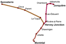
By train
[edit]
- Halte de Weymont (Weymont stop), street A, ☏ + 1-888-842-7245, relations_clientele@viarail.ca.
By car
[edit]- From La Tuque (115 km (71 mi). Time: 3 hr 50 min. Take rue Bostonnais (northbound) which becomes chemin Fitzpatrick; take the forest road 461 (25) (westbound) to the village of Wemotaci.
- From Parent (83 km (52 mi). Time: 2 hr 40 min. Take forest road 450 (22) (north-east direction); take the forest road 451 (25) (south-east direction); after crossing the bridge over the Manouane river, take the 461 (25) (northbound) to the village of Wemotaci.
Get around
[edit]- 2 Wemogaz, 1, rue Acokan, ☏ +1-800-686-9243. Gas station.
See
[edit]- 1 Ancienne réserve (Old Reserve), ☏ +1 819-523-5930, toll-free: +1-877-424-8476. accessible at all times. Site of the former Wemotaci reserve.
Do
[edit]Outdoor activities
[edit]- Snowmobiling.
Events
[edit]- Pow-wow. Annual Indigenous event rich in culture in early September. Shows of indigenous dances and ceremonies. Hundreds of visitors come to attend this Pow-wow.
Buy
[edit]- 1 Bonichoix, 6, rue Acokan, ☏ +1 819 666-2323. General grocery.
- 2 Dépanneur Wemok, 121, rue Wemotaci, ☏ +1 819 666-2929, infoservice@ville.latuque.qc.ca.
Eat
[edit]- 1 Restaurant Aski, rue A. Meals on site. Take-out orders.
Drink
[edit]- 1 Chez VIP, 10A, rue Kenosi, ☏ +1 819-523-7711.
Sleep
[edit]The closest lodgings to Wemotaci are in La Tuque. Wild camping may be possible for experienced travellers.
Cope
[edit]- 2 Wemotaci Kitotakan, 74 Kenosi, ☏ +1 819 666-2668. Radio station. Frequency: 89.9 FM
Go next
[edit]- La Tuque (from the village of Wemotaci, take route 461 (25) (direction La Tuque), up to chemin Fitzpatrick; then head south, to downtown La Tuque). A destination for recreational tourism (vacationing, hunting & fishing, snowmobiling, mountain biking, nautical activities, observation of flora and fauna, boating, etc.)
- Obedjiwan (from the village of Wemotaci, take route 461 (25) (direction La Tuque), up to chemin Fitzpatrick; then head south to downtown La Tuque). 9.27 km2 (3.58 sq mi) First Nations reserve on a peninsula, between Kamitcikamak lake (to the west) and Wapisiw bay (to the east) on the north shore of the Gouin Reservoir.


