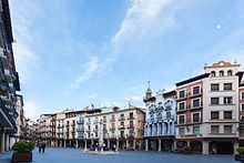
Aragon (Spanish and Aragonese: Aragón, Catalan: Aragó) is a region in the north of Spain. Despite seeing limited tourist traffic compared to other regions, it holds a wealth of unique sights, with villages and towns rich in architectural history picturesquely extending on the hillsides and in the valleys in the midst of the barren, mountainous countryside

Cities
Towns and villages
Other destinations
- 1 National Park of Ordesa and Monte Perdido (Huesca). 2 Monte Perdido is the third highest mountain in the Pyrenees.

- 3 Sos del Rey Catolico (Zaragoza)
Understand
Aragon is the heart of what was in the Middle Ages the Crown of Aragon, which also included regions like Valencia, Murcia, Catalonia, the Balearic Islands, Venice, the South of Italy, Sicily and some Greek colonies. In the 15th its King Ferdinand married Isabel of Castile and formed the Kingdom of Spain. Although it used to have its own language, Aragonese, and laws, over the centuries most of them were lost and it became more like Castile.
Nowadays, Aragon, despite its large size, has a population of only 1 million, making it largely uninhabited, with the capital, Zaragoza, holding over half the population.

Nature
Some interesting plants even for a non-biologist are:
- Blackberry: can be found on the slopes of Guara and Pireneus mountains.
- Acorn: There are two types of non-oak acorn, and at least one of them grows on bushes rather than on trees.
Talk
Spanish is spoken in Aragon by the whole population.
Aragonese (Aragonese or Castilian: aragonés, also known as fabla), is spoken in the north, but is not recognized as an official language. This language is similar to Catalan and Castilian with some Basque and Occitan influences. Catalan is also spoken in the East of the region (Catalan: 'Franja de Ponent, literally West Strip, being West of Catalunya), though it has no official status.
Get in
Aragon is connected to France by roads and tunnels (Somport) but not by train. It has no coast, so it's not accessible by boat.
There is an airport in Zaragoza (ZAZ IATA), served by low-fare carriers offering flights to secondary airports in some European countries, as well as domestic flights. As the Madrid-Barcelona high-speed railway line runs through Aragon, you can also use the airports in Madrid–Barajas Airport (MAD IATA) and Barcelona (BCN IATA), which offer many more international and intercontinental connections.
Get around
By car
Roads are really good in the region and its towns. Even if you go canyoning or other active sports, typically you don't need a 4x4, as you always leave car on a parking near starting point of activities.
By bike
Cycling is very popular sports in the region, and the roads are really good.
See


- Isabena valley, a beautiful but very desolate valley in the alta ribagorza
- Mudéjar Architecture of Aragon — ten UNESCO World Heritage Listed buildings around the region
- Monte Perdido/Mont Perdu — located at the border to France, it's the third tallest mountain in the Pyrenees and inscribed on the UNESCO World Heritage List
Do
Rock climbing: Los Mallos for serious climbers.
Hydrospeed: Ideal time is April-May, as it requires much water in the rivers.
Whitewater rafting: Multiple operators and a kayaking school can be found in the town of Campo; some rafting can be found in Murillo de Gallego.
Hiking : routes can be find in Senderos turisticos de Aragon. Also, you might want to follow the guides of Sobrarbe geopark, where you can find a lot of hinkings trails. You can download a gpx file with 351 tracks here, and you can find the individual files here.
Canyoning: According to outdoor activities operators, Aragon canyons are the best in Europe (most long and intensive) and third in the world--and there are up to 150 canyons available in the region. In summer, about 16 canyons are in active use. May is ideal time for experienced canyoners: almost every canyon have just enough water, and water is warm enough. June-July and September is good for well-fit canyoners. August is a peak season for non-experienced canyoners looking for fun with minimal effort.
Canyons are both in Sierra de Guara and Pireneus. In the whole region, there's no places for horizontal abseiling (like moving over a rope above a river from one side of canyon to another). Most canyons were originally discovered and gone through in 1970s. Alquezar is the main starting point for canyons in Aragon.
Equipment to bring for commercial canyoning specific for this region: shoes for slippery stones.
Canyons
- Aigueta de Barbaruens: Features: About 15 jumps up to 10m (several of them in quite unexpected locations); 2 to 4 abseils (two of them are better as high jumps); several slides, including 5m-long and a twisting one (hands-up only). T-shirt is recommended on your way from parking to the canyon: windy even in August; no direct sunlight; bush is not always easy to go through. 70% of canyoning time is spent without direct sunlight. Serious level difference between entry and exit. In late August, very clean water well under 10°C.
- Alcanadre
- Balces
- Basender
- Cabrito
- Chimiachas
- Formiga: Typical durations: 3 hours in canyon; 45min walk to entry to canyon from nearest parking; 20min to walk from exit from canyon to parking. Features: several jumps (up to 7m); about 5 slides (one face-down; another with 2-3m high jump); two jump-unders; two abseils (one dry at the entry, and one near waterfall with slippery vertical rock). Small section of via ferrata preceding the entry. In late August, very clean 14°C water. No T-shirt is necessary.
- Fornocal: exit is 2nd closest to Alquezar
- Monzon
- Pionera
- Portiacha
- Río Vero: exit is closest to Alquezar
- Sarratanas
- Trigas

Eat
Borraja:
Ternasco:
Trenza de Almudevar y Huesca:
Longaniza:
- Frutas de Aragón. Macerated and cooked fruits with chocolate around them.
Drink
Excellent wines of the region: Somontano, Cariñena, Borja, Paniza, Calatayud, Lecera and Valle de Jalón.

