
Cycling the Western Sahara
The Western Sahara cycle route runs from Guelmim in Morocco via Mauritania to Saint-Louis in Senegal. It is 2,100 km (1,300 mi) through the Western Sahara, crossing the westernmost part of the Sahara (bordering the sea) while avoiding disputed territories controlled by the SADR (Saharan Arab Democratic Republic).

Understand
[edit]The route is asphalted from Morocco to Senegal. Only a few kilometers along the Moroccan-Mauritanian border are soft slopes (as of 2006). There are supply possibilities at the latest every 150 km (93 mi), which corresponds to 2–3 days. This route is the easiest way to cross from North Africa to the Sub-Sahara countries by bike (as of 2006).
Geography
[edit]The Western Sahara is divided geographically into a northern part, from the Cape Boujdour, where flat-corrugated gravel and deserts (Hammada) dominate. The terrain gradually rises from the coast to the interior of the country to a height of about 400 meters. The southern region is almost completely flat with isolated sand dunes (erg), which provide only a little variety in the uniform, almost vegetation-free gerbera.
Grassy and bushy areas as well as acacia mark the transition from the desert steppe to the Saw Saw in Southern Mauritania.
Animal species adapted to the dry habitat are found, for example, scorpions, snakes, Jaculus jerboas and spiny-tailed lizards. In the caves on the Atlantic coast, especially on the Cabo Blanco peninsula near Nouadhibou in Mauritania, live the largest populations of the endangered Mediterranean monk seal.
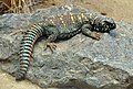 Spiny-tailed lizard (Uromastycinae)
 Fat-tailed scorpion (Androctonus australis)
 Puff adder (Bitis arietans)


_juvenile_(16156642643).jpg)
Climate
[edit]The Sahara is a turning-desert, caused by the constant, dry-hot north-east trade wind. Even in the age of shipping, the trade winds served as powerful tow-lifts. On the bike, you are constantly pushed southwards by the wind. It also transports a lot of dust and sand near the ground.
Especially in the spring and autumn strong deep-pressure areas can suck Saharaluft over the Mediterranean. The dry, hot south-south-east sand and dust winds, the Schirokko, are formed. Due to the large amounts of sand dust, the air turns yellowish-reddish-brown. The strong headwind can make it difficult to get to the South and quickly get you into an unpleasant situation.
Along the coast, north of Nouakchott, the temperatures are moderate due to the balancing influence of the Atlantic. The cold canal stream provides for the cooling, but is also responsible for the powerful fog in the coastal area. Around the turn of the year it has 20 °C (68 °F), in September and October the temperature rises to 30 °C (86 °F).
On the coast south of Nouakchott and in the region along the Senegal river the temperature around the turn of the year is 20–24 °C (68–75 °F) and it rises to 30–34 °C (86–93 °F) in July. Especially in the south, the humidity is significantly higher with a rainy season in July–October with a total of 400 mm (16 in) of precipitation.
| Jan | Feb | Mar | Apr | May | Jun | Jul | Aug | Sep | Oct | Nov | Dec | |
|---|---|---|---|---|---|---|---|---|---|---|---|---|
| Average maximum temperature | 20.9 | 22.7 | 23.7 | 23.3 | 24 | 24.8 | 25.7 | 26.5 | 27.4 | 26.6 | 25.1 | 22.5 |
| Average minimum temperature | 13.3 | 13.8 | 14.7 | 14.9 | 15.8 | 16.7 | 17.5 | 18.3 | 18.8 | 18 | 16.6 | 14.5 |
| Average precipitation | 2 | 3 | 1 | 0 | 0 | 0 | 1 | 2 | 11 | 6 | 3 | 10 |
| Jan | Feb | Mar | Apr | May | Jun | Jul | Aug | Sep | Oct | Nov | Dec | |
|---|---|---|---|---|---|---|---|---|---|---|---|---|
| Average maximum temperature | 28,8 | 30,4 | 32,5 | 32,8 | 34 | 33,3 | 31,7 | 32,1 | 34,1 | 34,9 | 32,7 | 29,2 |
| Average minimum temperature | 12,7 | 14,3 | 16,7 | 17,8 | 19,6 | 21,8 | 23,4 | 24,1 | 24,3 | 21,8 | 18 | 14 |
| Average precipitation | 0 | 2 | 2 | 0 | 0 | 0 | 14 | 37 | 28 | 7 | 1 | 7 |
| Jan | Feb | Mar | Apr | May | Jun | Jul | Aug | Sep | Oct | Nov | Dec | |
|---|---|---|---|---|---|---|---|---|---|---|---|---|
| Average maximum temperature | 30 | 32.1 | 33.6 | 33.9 | 33.9 | 33.8 | 32.4 | 32.8 | 33.6 | 35 | 33.6 | 30.7 |
| Average minimum temperature | 15.4 | 16.1 | 17.5 | 18.2 | 19.6 | 22.1 | 23.6 | 24.3 | 24.3 | 22.6 | 19.3 | 16 |
| Average precipitation | 1.6 | 1.3 | 0.4 | 0 | 0.4 | 7.6 | 42.4 | 89.7 | 84.9 | 24 | 0.9 | 1.3 |
Travel time and distance
[edit]The Western Sahara is, in principle, passable all year round. Rain is rare and mist formation occurs mainly near the coast. The temperatures are tempered by the proximity to the sea. The wind blows mostly from north to south, only in the spring and autumn one must reckon with opposite wind through the Shirokko. The winter months with the coolest temperatures and stable trade winds have a slight advantage in the choice of travel time.
Due to the trade winds, covering 80 km (50 mi) in a day is realistic. That would require about 30 days from Guelmin to Saint Louis, plus time for stays in the larger cities and for border crossings.
Prepare
[edit]The situation can change dramatically along the route. Settlements can change, roads can become impassable through wandering dikes. Much of the information on the Internet or in books refer to the route before 2005, when the road was not yet developed. At that time large sections had to be crossed over sandy slopes. So always check that your information is up to date.
Therefore, accurate searches are required before departure. Locals are a valuable resource, as are other travellers.
Stay healthy
[edit]Water is surely the first thing that comes to mind when travelling through the desert. The daily per capita consumption of drinking water is about 5 liters. For tours further inland, with extreme temperatures, up to 6 liters and more. Add the water needed for cooking.
It is best to avoid the midday heat and bike in the early morning and afternoon. In the case of the large liquid loss by sweating, the salt loss should also be compensated for. The World Health Organization recommends, for each liter of water, a teaspoon of salt and 6 teaspoons of sugar. However, too much salt or sugar can aggravate dehydration. The Rehydration Project uses only half a teaspoon of salt with 6 teaspoons of sugar per liter of water. Contrary to popular opinion one can not adapt to water deficiency.
Cooking
[edit]The consumption of water for cooking can be reduced by using water-saving food. You need a cup of water for a cup of couscous and, for rice, twice the amount.
The supply of gas cartridges is scarce in the Western Sahara. Benzine fuel is available in every major place.
Cycling
[edit]First choice would be a touring bicycle. With 28" tires you can get on the asphalt fast and are nevertheless armed for desert descents. Ideally a bike with a steel frame as if repairs are required steel welding tools can be found more commonly than aluminum welding tools.
Sand and dust act like sandpaper on the sprockets and the chain expands under stress. To increase longevity you can take two or three chains and change every 800–1,000 km (500–620 mi). This means that you can reach distances of up to 10,000 km (6,200 mi). Then you should change the entire drive system.
Get in
[edit]Guelmim is the last place before the desert and starting point of the bike tour; check its page for information how to get there.
Go
[edit]
1 Guelmim (Arabic: كلميم, also Goulimine or Guelmin) is a provincial capital of about 12,000 inhabitants in the Guelmim-Oued Noun. The place Bir Anzarane is the center of the city. Here you can find the 1 Banque Populaire with ATM and the 1 post office. The 1 bus station is north of the square, along the Blvd Moulay Rachid.
From Guelmin to Tan Tan (130 km (81 mi))
[edit]Leaving Guelmin via Avenue 3 Mars, head south-west. Past the Mosque of Guelmin you pass the city gate.
- 1 Crossing the Oued Siyad.
- 1 Café Blue House (25 km (16 mi) past Guelmin).
- 2 Turnoff to Ait Yassine and Aferkat.
- 3 Bus stop, turnoff to Labyar (Arabic: البيار) (44 km (27 mi) past Guelmin).
- Simple restaurant (50 km (31 mi) past Guelmin).
- 4 Settlement Rass Oumlil with Restaurant and Magasin (70 km (43 mi) past Guelmin).
- Viewpoint (88 km (55 mi) past Guelmin).
- 5 Crossing the Oued Draa. which, after its long journey from Zagora, flows through the desert just a few kilometers further west into the sea.
Tan Tan
[edit]6 Tan-Tan (Arabic: طانطان, also al-Hamra, the Red) with 70,000 inhabitants is the capital of the province of the same name in the Guelmim-Oued Noun region. The city is located south of the main street Ave Hassan II, on which one finds the 7 post and the bank 8 BMCE, with ATM, next to the Shell gas station. The second main road is the Ave Mohammed V, which crosses the city to the south. There is the 9 Banque Populaire and the 10 Busstation (Gare Routiére) at Place de la Marche Verte in the south of Ave Mohammed V. The 11 airport of Tan Tan ![]() Plage Blanche Airport (TTA IATA) is located 8 km (5.0 mi) west of the N1. It is served by the Royal Air Maroc, which connects Tan Tan with Casablanca and Guelmin.
Plage Blanche Airport (TTA IATA) is located 8 km (5.0 mi) west of the N1. It is served by the Royal Air Maroc, which connects Tan Tan with Casablanca and Guelmin.
From Tan Tan to Tarfaya (213 km (132 mi))
[edit]
If you leave Tan Tan to the west on the N1 you reach the turnoff to the airport after 6 km (3.7 mi). A kilometer further on, the R101 turns of left, which leads to Smara (Arabic: السمارة), some 240 km (150 mi) away in the south. Shortly thereafter, a track on the right leads to the Atlantic Ocean, 35 km (22 mi) away, from Oued Drâa. 25 km (16 mi) to Tan Tan you can reach 2 El Ouatia ![]() (Arabic: الوطية, auch Tan Tan Plage). There is guarded parking on the beach
(Arabic: الوطية, auch Tan Tan Plage). There is guarded parking on the beach
El Ouatia
[edit]El Ouatia, with its 6500 inhabitants, is one of the largest fishing ports in Morocco. The city is becoming increasingly popular among surfers and offers many hotels. At the entrance to the city you pass a roundabout from which the N1 turns southwards. Go straight ahead into the city. The road to the north leads to the mouth of Oued Drâa, 30 km (19 mi) away, into the Atlantic. Next to the roundabout is the 1 Hotel Korea House (+212 641-431661).
- 2 Camping Atlantique Tantan.
- 3 Camp Sables d'Or.
- 4 [dead link] Camping Equinox Tan Tan.
- 5 Riad Essadia.
- 6 Hotel La Belle Vue, ☏ +212 662021619, labellevuehotel@gmail.com.
- 2 Café Asfi.
- 1 Restaurant Bergach.
The N1 follows its way south to Akhfenir , very close to the imposing cliff. After about 35 km (22 mi) you cross the 1 Oued Chbika. Climbing up the Wadi, you hit a checkpoint with supply possibilities.
- 12 Oued crossing.
- 13 Oued crossing (70 km (43 mi) past El-Ouatia).
- 14 Devil's hole (French: Gouffre d'Akhfenir or Trou du diable).. A hole about 25 meters in diameter and 30 meters deep

- 15 Akhfenir (about 90 km (56 mi) post Ouatia).


Akhfenir
[edit]South of Akhfenir is one of the largest wind parks in Africa with 131 wind turbines on an area of over 8,900 hectares. A piste leads from Akhfenir to the wind farm, 20 km (12 mi) away, that was listed in the Jeune Afrique magazine as one of the ten most outstanding projects in Africa.
- 7 Hotel Restaurant Atlas.
- 8 Hotel Sahara Beach.
- 2 Pâtisserie Oumaïma.
- 16 Gas station.
- 9 [dead link] Hôtel La Corniche, ☏ +212 661-224250.
- 10 [formerly dead link] La Courbine d'argent.
From Akhfenir the coast becomes flatter again. After approximately 10 km (6.2 mi) the N1 turns off the coast and runs in an arc around the 1 Khenifiss National Park ![]() (Arabic: المنتزه الوطني اخنيفيس, french: Parc National de Khenifiss).
(Arabic: المنتزه الوطني اخنيفيس, french: Parc National de Khenifiss).
Khenifiss National Park
[edit]The Khenifiss National Park was established in 2006, from the natural reserve of the time, and covers 1,850 km2 (710 sq mi). The park was listed as an UNESCO World Natural Heritage Site in 1998. The park is located on the largest lagoon on the Moroccan coast. Ruddy shelducks (Tadorna ferruginea), marbled ducks (Marmaronetta angustirostris) and Audouin's gulls (Ichthyaetus audouinii) breed here. The mainland is characterized by sabkhas, shallow basins, which are only temporarily watered. Cuvier's gazelles (Gazella cuvieri) were also seen here. In Akhfenir there are numerous guides for tours to the national park. For photo excursions see Rosa Frei Photography, Ouarzazate, rosa@rosafrei.com..
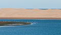 Sand dunes in the national park
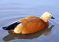 Ruddy shelduck
 Marbled duck
 Audouin's gull
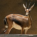 Cuvier's gazelle


After the national park, the N1 meets the coast again. You pass, about 163 km (101 mi) to Ouatia, a small 1 café without WC on the coast and a 17 wreck on the beach.
After 35 km (22 mi) you reach a petrol station at the 2 crossing before Tarfaya. The N1 turns south towards El Aaiún. If you follow the road straight, you reach 3 Tarfaya (Arabic: طرفاية) after 5 km (3.1 mi). Worth seeing the museum on the post flights and Fort Jubly. There is a banc with ATM in town.
Tarfaya
[edit]

Tarfaya is a small town with a population of more than 8,000 at Cape Juby in the Laâyoune-Sakia El Hamra region. The city is the administrative center of the province of the same name.
The main road through the city is the Ave Ahmed Haidar. In the west you can see the 2 Banque Populaire. On the beach is a monument, in the form of a green plane, for the post flights. Among other things, the writer and pilot Antoine de Saint-Exupéry was stationed here. There is also the 1 Museum Antoine de St Exupery, which is 1 km (0.62 mi) from the coast. One kilometer off the coast are the ruins of the fortress 18 Casa Mar, built by the English in the 1880s. At the beginning of 2008, a ferry service between Tarfaya and Puerto del Rosario on Fuerteventura was opened. This gave Tarfaya a modest economic upturn until the car ferry Assalama leaked in the port of Tarfaya in April 2008 and stranded in the shallow waters where it is still today.
- 11 Hotel Casamar, ☏ +212 5288-95326.
- 12 Hotel Canalina, Ave Mohamed V (next to the Centre de Santé), ☏ +212 641 785 521.
- 3 Cafe Boufous, Ave Ahmed Haidar.
- 19 Attijariwafa bank, Rue Mejjat.
- 20 Pharmacie de Place Saint Exupery, Ave Qaied Baba Ahmed Oueld Youssef.
- 21 Post.
- 3 Snack Restaurant Le9 Delice.
- 1 Marché municipial.
From Tarfaya to El Aaiún (104 km (65 mi))
[edit]Leaving the city south, you reach a 22 roundabout. The road straight to the south leads back to the N1. On the right a road branches off, which follows the coast to Foum ed Oued (state unknown). After 30 km (19 mi) on the N1 you reach 23 Tah, a small town with cafe, motel and fuel. In the center is a monument for the Green March. 45 km (28 mi) past Tarfaya, you pass the turn-off for Daoura (Dawra). After 100 km (62 mi) you reach 24 El Aaiún.
El Aaiún
[edit]

El Aaiún (Arabic: العيون, also Laâyoune) is the largest city in the territory administered by Morocco and the capital of the Moroccan administrative region Laâyoune-Sakia El Hamra.
Most banks, hotels and the post office are located on Blvd Hassan II or Blvd de Mekka. The most important square of the city is the 25 Place du Mechouar.
El Aaiun Hassan I Airport (ICAO: GSAI / GMML) is 2 km (1.2 mi) southwest of the N1. It is most often fueled by Royal Air Maroc and Canarian Binter Canarias. The destinations are spread over three countries: Las Palmas (Spain), Agadir, Casablanca, Ad Dakhla and Rabat (Morocco) and Paris-Orly (France).
- Buy
- 26 Banque Populaire, Place Dchira.
- 27 BMCE, Place Dchira.
- 28 BMCE, Place Hassan II.
- 29 Royal Air Maroc, Place Dchira.
- 2 Ensemble Artisanale, Blvd de Mekka.
- See
- 30 Spanish Cathedrale Franz von Assisi, Ave Hassan II. situated in a nice parc
- 31 Souq Djal. the livelist part of town and has the best restaurants
- 32 Moulay Abdel Aziz Mosque, Blvd Moulay Youssef.
- Smara (Arabic: السمارة), capital of the province Es Semara is accessible via the N5. It is 240 km (150 mi) into the interior in an almost vegetationless solid stone and sand desert.
From El Aaiún to Boujdour (193 km (120 mi))
[edit]The Ave Mohammed V crosses the N1 at Place du Mechouar, which leads west from the city. Past the airport it turns 13 km (8.1 mi) after the Place du Mechouar sharp south to El Marsa. At the bend, the road branches off to 4 Foum el Oued, which is reached after a further 6 km (3.7 mi).
Foum el Oued
[edit]Foum el Oued (Arabic: فم الواد), also known as the Riviera of the Sahara is particularly popular among the locals.
- 13 Camping Nil.,clean, cold water only, restaurant only in summer
From Foum el Oued it is 10 km (6.2 mi) across the coastal road Ave Ennahda to 5 El Marsa ![]()
El Marsa
[edit]El Marsa (Arabic: المرسى, also Laâyoune Plage) with about 10,000 inhabitants is the last city to Boujdour, 160 km (99 mi) further south. There are some simple cafes and shops.
- 4 Café el Puerto.
- Hotel Marsa, Ave Hassan II.
Shortly after the southern end of the station, crossing the N1 is the world's longest 33 conveyor belt. It transports the phosphate from the mining town of Bou Craa (Arabic: أبوكراع) to the port of loading at El Marsa.
- 34 turn-off for Plage Kerouma (22 km towards El Marsa). with restaurant at the beach
- 35 Lamsid (Arabic: لمسيد) (82 km nach El Marsa)., fuel station with restaurant
80 km past Lamsid is 36 Boujdour. ![]()
![]()
Boujdour
[edit]Boujdour (Arabic: بوجدور) is the small city in the province of Laayoune-Sakia El Hamra at Cape Bojador (Arabic: رأس بوجادور, french: Cape Boujdour), with 45,000 inhabitants. It forms the western foothills of the mountain range Jebel el Aswad in the Sahara and was considered in the Middle Ages as the western end of the world (finis terrae). Here you will find the highest sand dunes (Erg), up to 130 m, in the mostly flat coastal region of the Hammada.
Along the N1, which passes through the city as Ave Hassan II, are the most important shops, restaurants and hotels.
From Boujdour to Ad-Dakhla (345 km)
[edit]- 41 two wrecks (18 km past Boujdour).
- 42 wreck.
- 5 Café (140 km past Boujdour).
- 6 fuel station Sahara (148 km past Boujdour).
- 43 Oued Karaa (Arabic: واد لكراع, Echtoucan) (180 km past Boujdour).
- 44 N'Tireft (Arabic: نتيرفت).
- 45 unbekannt (280 km past Boujdour and 60 km to Dakhla).
- 46 crossing Dakhla-Argoub.
- 47 Unofficial camping site (10 km past the turn-off to Dakhla).
Ad-Dakhla
[edit]
- 48 Ad-Dakhla is the southernmost city in the Western Sahara and the capital of the Dakhla-Oued Ed Dahab region.
Dakhla lies on plains that are 38 km long and 4 km wide. These extend to the south-west, parallel to the coast, and enclose the Rio de Oro bay. The adjoining mainland and the peninsula consist of a nearly vegetationless sand and cliff (reg). The north coast of the peninsula, which is open to the sea, is situated between short, rocky stretches of kilometers of sandy beaches which are not yet accessible only because of the great distance to the tourist resorts of Morocco. The city stretches along the east side of the peninsula with the Blvd Mohammed V as a waterfront promenade. To the north, parallel to the main commercial street Boulevard Walae. In the south, the business district surrounds the large mosque. The airport of Dakhla is connected several times a week from Casablanca.
- Get around
- 2 Grande Taxi.
- See and do
- 49 Church Notre Dame de Carmen.
- Buy
- Eat
- 7 Marché Municipal Couvert, Boulevard Al Masjid.
- 8 Boulangerie.
- 9 Supermarché Errihimi.
- 10 Supermarché Aït Oubaha, Rue Oued Tansift.
- 11 Bakery Assalam, Rue Oued Tansift.
- 12 Café Oued Eddahab.
- 13 Restaurant Samarkand, Blvd Mohammed V.
- Sleep
- 16 [dead link] Hotel Erraha.
- 17 Sahara Regency, ☏ +212 5289-31666.
- 18 [dead link] Hotel Imperial Playa, Ave Mohammed V, ☏ +212 5288-92212.
from Ad-Dakhla to Guerguerat (367 km)
[edit]- 14 El Argoub (Arabic: العرڭوب) (40 km past the crossing Dakhla-Arghoub).
- 51 Imlili (Arabic: إمليلي) (45 km past El Argoub).
- 52 Tankstelle Chica (50 km past El Argoub).
- 19 Barbas (Arabic: بئر كندوز) (210 km past El Argoub).
- rock landscape (30 km past Barbas).
- Sendemast einer Radarstation (50 km nach Barbas).
- rock landscape (shortly before Guerguerat).
- 53 Guerguerat (Arabic: ڭرڭورات مغربية) (80 km nach Barbas).
Border Morocco-Mauretania
[edit]from the border to Nouadhibou (60 km)
[edit]- 56 Passing the ore line and the crossing Nouadhibou-Nouakchott (20 km past Guerguerat, 40 km to Nouadhibou, 40 km to Bou Lanouar, 430 km to Nouakchott).
Nouadhibou
[edit]
57 Nouadhibou is located on the protected east side of the Ras Nouadhibou land, which stretches for 40 km into the Atlantic Ocean and borders Dakhlet Nouadhibou (formerly Baie du Lévrier). To the north is the most populous district, Numerowat, which is divided into six Robinets (French: waterway). In the center, at the northern end of the semicircular Cansado Bay, lies the business district (simply Ville), on the straight main road Blvd Médian and the parallel Blvd Maritim, to the east, parallel to it lie banks, exchange offices, police and sales. Eight kilometers south of the town center is the district of Cansado (Spanish: tired). Just north of Cansado, a five-kilometer road branches off to the west coast to the ruins of La Gouira, a former Spanish trading center. The southern tip of the peninsula has been declared a National Park, where, apart from Mauritanian soldiers and a 58 lighthouse, some of the rare Mediterranean monk seals are still to be found. 59 wreck.
Nouadhibou has an international airport (NDB IATA). There are regular flights to Nouakchott and irregular to the airport of Gran Canaria.
- Buy
- Eat and drink
- 15 Restaurant Quijote.
- Sleep
- 20 Auberge La Chinguetti, Numerowat, 1ere Robinet, Bd Median.
- 21 Hotel Al Jazeera, Blvd Maritim.
- 22 Hotel Sahel.
- 23 Hotel Prestige.
- 24 Camping Baie de Levrier, Blvd Median (in front of the police station).
- Cope
- Connect
- 5 Post.
from Nouadhibou to Nouakchott (436 km)
[edit]National Park Banc d'Arguin
[edit]The national park [formerly dead link] is located on the Atlantic coast of Mauritania between Nouakchott and Nouadhibou and was designated 1976. Since 1989, he has been listed as a UNESCO World Heritage site.
It includes the Arguin Sandbank, which is located on the coast of Mauritania and reaches the Atlantic with its shallow reefs up to 30 nautical miles. The Sandbank was considered one of the most dangerous places on the West African coast. Ships usually keep wide distance from this dangerous coastal section. Furthermore the 60 island Arguin north and several smaller islands such as the two Kiaone Islands, 61 Kiaone West and 62 Kiaone Ost in the south.
The park is one of the most important wintering areas of the Great Bluebird. In addition, many colony breeders such as pink flamingos, spoonbills, rosapelikans, predators, king and tigers-, as well as thin-billed gulls.
 Whimbrel (Numenius phaeopus)
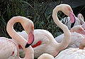 Greater flamingos (Phoenicopterus roseus)
 Common spoonbill (Platalea leucorodia)
 Great white pelican (Pelecanus onocrotalus)
 Caspian tern (Hydroprogne caspia)
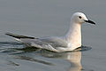 Slender-billed gull (Chroicocephalus genei)


- 63 Abzweigung zum Dorf Bou Lanouar (80 km nach Nouadhibou).
- Filling station (only diesel) (2 km nach Abzweigung nach Bou Lanouar).
- Auberge (45 km nach Bou Lanouar).
- Baumgruppe (65 km nach Bou Lanouar).
- 64 unfertige Tankstelle (70 km nach Bou Lanouar).
- Zelte mit Auberge und Epicerie (95 km nach Bou Lanouar).
- Zelte mit Holzbaracken, Café, Auberge (160 km nach Bou Lanouar).
- Zelte, Restaurant (190 km nach Bou Lanouar).
- Baracken (275 km nach Bou Lanouar).
- 65 Barackensiedlung (290 km nach Bou Lanouar).
- 66 Abzweigung nach Lemcid (320 km nach Bou Lanouar).
- Piste nach rechts zum Fischerdorf Belakahr (340 km nach Bou Lanouar).
- Checkpoint. Die letzten 25 km 4spurige Straße durch Müllhalden (365 km nach Bou Lanouar).
Nouakchott
[edit]
67 Nouakchott (Arabic: نواكشوط), 390 km to Bou Lanouar, with 96000 inhabitants, is the capital of Mauritania.
The main traffic route, Ave Gamal Abdel Nasser, runs east-west through Nouakchott and ends at the harbour, 6 km to the west. In the center of the city, it is crossed by the second main road, Ave du Général de Gaulle, which crosses the city in north-south direction. At the intersection is the tallest building in the city, the ten-storey 68 hotel and convention center Al-Khaima (Arabic "tent"). In the northern part of the Ave Général du Gaulle lie the business and embassy district. The rest of the city consists of planar-grounded unpaved roads.
Information
[edit]- 69 [dead link] Austrian honorary consul, 10, Rue Mamadou Konaté, Al Khaima City Center, 5. Stock (by the Saudi mosque), ☏ +222 4525 5131, consulautrichemauritanie@yahoo.com.
- 70 Main post, Ave Gamal Abdel Nasser.
- 71 Mauretanian central bank (BMCI), Ave Gamal Abdel Nasser.
- 72 Landeskrankenhaus (Centre Hospitalier Nationale Sabah), Ave Gamal Abdel Nassar.
See
[edit]Buy
[edit]Sleep
[edit]From Nouakchott to Rosso (205 km)
[edit]Rosso
[edit]79 Rosso ![]() (Arabic: روصو), the third-largest city in Mauritania (by 2000), with almost 50,000 inhabitants. Good infrastructure. The main road runs through the village directly to the port. The center is located east of the main road.
(Arabic: روصو), the third-largest city in Mauritania (by 2000), with almost 50,000 inhabitants. Good infrastructure. The main road runs through the village directly to the port. The center is located east of the main road.
- 80 Hotel Alasmaa (at the northern entrance).
- Church., probably the oldest church in Mauritania.
Border Mauritania – Senegal
[edit]With independence from France, the border between Mauritania and Senegal was drawn along the Senegal River and Rosso was divided. On the Mauritanian side, tax collectors are always trying to claim penalties for false visas and processing fees for stamps. Also, the price for the ferry over the Senegal River is negotiable. Better spend more time and discuss the arguments calmly and creatively. In general, here too, as a cyclist, you are less likely to be victimized than if you were driving a car.
From the border to St. Louis (98 km)
[edit]The border town 81 Rosso (Senegal) has about 10,000 inhabitants. Probably the only accommodation is the 28 Auberge le Wallo near the port on the main road. A little further along the main road is the 2 Gare Routière.
A trip to Richard Toll
[edit]6 km to Rosso, turn left at the junction to 82 Richard Toll ![]() , which is reached in another 13 km. Richard Toll has about 70,000 inhabitants and is mainly known for the processing of sugar cane.
, which is reached in another 13 km. Richard Toll has about 70,000 inhabitants and is mainly known for the processing of sugar cane.
Saint Louis
[edit].JPG)
87 Saint Louis, since 2000 UNESCO World Cultural Heritage, has about 176,000 inhabitants. The center of the city is located on the island of Ile de N'Dar, which is connected to the mainland by the 500-meter-long Pont Faidherbe. Over another bridge, Pont Mustapha Malick Gaye, you reach the Langue de Barbarie peninsula.
Festland
[edit]- 88 Main train station.
Ile de N'Dar
[edit]Langue de Barbarie
[edit]- 94 Marché Ndar.
Respect
[edit]Religion
[edit]|
Ramadan
Ramadan is the 9th and holiest month in the Islamic calendar and lasts 29–30 days. Muslims fast every day for its duration and most restaurants will be closed until the fast breaks at dusk. Nothing (including water and cigarettes) is supposed to pass through the lips from dawn to sunset. Non-Muslims are exempt from this, but should still refrain from eating or drinking in public as this is considered very impolite. Working hours are decreased as well in the corporate world. Exact dates of Ramadan depend on local astronomical observations and may vary somewhat from country to country. Ramadan concludes with the festival of Eid al-Fitr, which may last several days, usually three in most countries.
|
Morocco is a Muslim country and faith is much more deeply rooted in everyday life than in Europe. The religious customs are observed. However, non-Muslims are treated with respect as different believers in Morocco. This is especially true during Ramadan. While most Moroccans fast, the sick, the young, the old and the pregnant do not, and neither need the travellers. Mauritania is officially an Islamic Republic, and is considerably less tolerant than Morocco, at least officially. Make sure not to do or say anything that could be considered blasphemy against Islam or proclaim yourself as an atheist while you are in Mauritania, and make sure to wear modest dress; atheism and blasphemy are punishable by death in that country, while "offending public indecency and Islamic values", "breaching Allah’s prohibitions" or assisting in their breach can be subject to up to 2 years in prison and a fine up to 600,000 Ouguiyas. Although 92% Muslim, Senegal is officially secular and known for its liberal Muslim majority; it also has a well-respected Christian minority and other smaller religious minorities that practice freely.
Photography
[edit]The desert is a breathtaking stage for photographers. The inhabitants are a bit different. The Moroccans and the Mauritians are not keen to be photographed. You should first ask politely. This applies in particular to portraits of women. With everything that could be in the remotest sense militarily interesting, you should be very careful. This applies mainly to bridges and checkpoints, but also to major road crossings, especially in the area of the Western Sahara. Otherwise, you may be subjected to interrogation.
Stay safe
[edit]The area of the Western Sahara, disputed between the SADR (Saharan Arab Democratic Republic), Mauritania and Algeria under international law, is always subject to tensions. Exact and up-to-date information must be researched before the trip. Women should not camp outside on their own due to the risk of extremist terrorist acts.
See the respective country articles for the latest information on safety and on visa requirements.
Search and rescue operations in remote regions are facilitated with accurate GPS data. Satellite Navigation GPS Tracker provides alarms for emergencies and are now cost-effective and handy.
Morocco
[edit]Morocco is a very safe and very friendly country, except in the big cities, especially Agadir, where a certain caution should be exercised. Pickpocketing happens especially if you aren't paying attention. Armed raids are rare.
The checkpoints in the Western Sahara are usually without problems. Sometimes imaginative scams are tried, such as trying to impose fines for missing authorizations or processing fees with imaginative arguments. In most cases it is possible to talk oneself out of the situation, but it is important not to underestimate Arab pride. You should always leave the other person a way out in the argument, without him losing his face.
Mauritania
[edit]Crime also plays an important role here in the larger cities. Particularly on the beach of Nouakchott, there is a strong risk of violent crime. Alcohol is expensive and difficult to get in Mauritania.
Mines, UXO
[edit]The area of the Western Sahara that is occupied by Morocco is separated from the territory of the Polisario by the Berm Wall. It is estimated that the world's highest density of mines can be found along the Berm. The Moroccan army, the Polisario and the UN are working on marking and removing mines and UXO (unexploded ordinance).
The risk should be very low along the main routes; however, you should exercise caution off the road and especially in the border area between Morocco and Mauritania. In 2015 there were floods in the area of the Western Sahara. Since then, there has been an increased danger of dislocated mines.
Go next
[edit]- Dakar
- Saloum-Delta national park