The dive site Blue Flame Pinnacles is an offshore rocky reef near Simon's Town in False Bay area near Cape Town in the Western Cape Province of South Africa.
Understand
[edit]This is an offshore site which may have lower swell than sites further east in a westerly swell, and is not as far away from the launching sites of Simon's Town. It may be a good option for a second dive on the way back from the Fleur.
Position
[edit]About halfway between the Fleur wreck and Whittle Rock.
1 Blue Flame North Pinnacles: S34°12.700’ E018°33.250’. The larger secion of reef and nominal position for the area. A fairly large area of granite reef with a group of long ridge-pinnacles aligned roughly northwest–southeast. The shallowest point is at about 25 m, with sand patches at about 33 m. The extent of the reef is not known in any direction.
1 Blue Flame South Pinnacles: S34°12.837’ E018°33.355’. A small cluster of very steep granite corestone pinnacles about 3.8 km north of Whittle Rock. The western and central pinnacles rise to about 25 m from about 34 m at the base, while the eastern is lower, at about 26 m on a flattish top, and wider. The pinnacles rise from a low profile outcrop a metre or two above the sand. A small site, but quite pretty.
This site is in the Table Mountain National Park Marine Protected Area, proclaimed in 2004. A permit is required.
Name
[edit]
The site is named for the boat Blue Flame, from which the first recorded dive at this site was made in 1998.
Depth
[edit]Maximum depth is about 35 m, and the top of the highest pinnacles at both north and south sites is at about 25 m. Average depth for a dive is likely to be about 30 m, excluding the ascent.
Visibility
[edit]Viz is likely to be a bit better than the inshore dives of Simon's Town, but not much is known about water circulation in the area. It may be considerably better than at the Fleur, on the same day, if there is dirty deep bottom water at the Fleur.
Topography
[edit]
The northern reef is probably the larger section, with massive outcrops rising from about 33 m to a shallow point of 25 m on the central ridge, and more lower reef extending in all directions, with a few strips of sand.
The southern pinnacles area is dominated by a line of three very steep granite pinnacles running roughly east to west, on a base of relatively low and flat granite outcrop probably surrounded by sand. There are other rocky outcrops nearby but they have not been described or surveyed. There appears to be more reef to the east of this section, but it has not been dived by anyone who took the trouble to make it known.
Geology: Granite corestone of the Pre-Cambrian Peninsula pluton.
Conditions
[edit]The site is exposed to wind from all directions, but mostly sheltered from swell with a westerly component, so should be dived when the swell is down or coming from the west and should be good in winter but there will be occasional opportunities at other times of the year. There can be plankton blooms in the area, but visibility may be acceptable, or even very good below the surface murk.
Get in
[edit]Only accessible by boat. The site is 12.7 km from Simon's Town Jetty, or 7.8 km from Millers Point slipway
See
[edit]Marine life
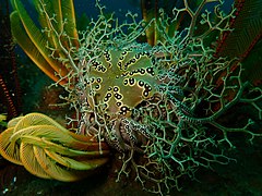
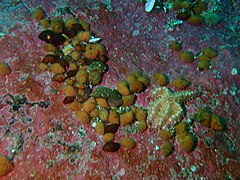
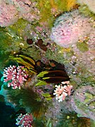
[edit]The pinnacles have a large number of strawberry anemones on the top surfaces and upper sides.
- Basket star and elegant feather stars
- Sponge or coral
- Strawberry anemones on the upper parts of the pinnacles
- Noble coral
- Sponge
- Spiny starfish
- Whelks
- Noble corals
- Bryozoan colony
- Sea cucumbers
- Sponge
- Fish
- Grey starfish
- Barbed wire siphonophore
- Ctenophore
Features
[edit]The pinnacles themselves are quite impressive in good visibility.

Photography
[edit]Fisheye or super wide angle shots could give good results if the visibility is reasonable to good, and there will be ctitters for macro work.
Suggested routes
[edit]Southern Pinnacles: A shot line will usually be placed at the pinnacles. The site is quite small and could be missed if there is much current. Start deep, and work your way up the pinnacles.
Northern Pinnacles: This is a much larger and more topographically varied site. It is not well known and there are no recommended routes.
Stay safe
[edit]Hazards
[edit]No known site-specific hazards
Skills
[edit]The ability to deploy a DSMB is recommended.
Equipment
[edit]Standard recreational equipment should be adequate, and nitrox will significantly extend no-stop time.
Nearby
[edit]Other offshore dive sites of False Bay:
- 1 Choirboys Reef
- 2 Seal Island
- 3 Drop Zone
- 4 East Shoal
- 5 Moddergat
- 6 Sterretjies Reef
- 7 York Shoal
- 8 SAS Fleur
- 9 Offshore Barges – North Barge
- 10 Steenbras Deep - South Pinnacles
- 11 SATS General Botha
- 12 Off-Whittle Ridge
- 13 SAS Bloemfontein
- 14 Whittle Rock
- 15 Bruce's Mark
- 16 Deep South Whittle Reef
- 17 Anvil Rock
- 18 SS Lusitania
- 19 Rocky Bank
Back to the Alphabetical list of sites, or list of reef dive sites in the northern False Bay offshore area
Other regional dive sites:
- Dive sites of Table Bay and approaches,
- Dive sites of the Cape Peninsula west coast
- Dive sites of the Cape Peninsula east coast
- Dive sites of False Bay east coast
- Fresh water dive sites of the Cape Town Metropolitan Area


