
Diving at Whittle Rock

Whittle Rock is an extensive offshore rocky reef on the central-west side of False Bay, near Cape Town in the Western Cape province of South Africa. There are several named dive sites and landmarks on this reef, which has not yet been fully explored or mapped.
Understand
[edit]


Whittle Rock and the surrounding reefs cover a large area, and are the most significant navigational hazard in False Bay, as they are in the approaches to Simon's Town harbour, but as very little shipping of large displacement enters the bay, it is not at present that much of a problem. The English East-Indiaman Euphrates is reported to have been wrecked on the reef, but its position is not known. Several anchors have been found, of various sizes, mostly of fairly old design. Some are thought to be from the Euphrates, and some of them are mapped. It is also a popular fishing area for reef fish, and a spectacular dive site. Almost the whole reef is within the depth range generally accepted for recreational scuba diving (40 m (130 ft)), and a fairly large area is accessible to entry level divers. It would certainly be more popular if it was closer to the launch areas. Visibility is often better than at the inshore sites on either side of False Bay on the same day. The reef extends about 1,300 m (4,300 ft) from east to west, and about 950 m (3,120 ft) from north to south, with sand patches in locally deep areas, and sand tongues leading up from the surrounding sand bottom between the lobes of the reef.
Position
[edit]
Whittle Rock reef is about 8 km offshore, west of Miller's Point, and south of Seal Island. There is officially a navigation buoy marking the navigational hazard, but there have been occasions when it was not there. The current buoy replaces one which sank some years ago. Divers have reported that it lies on the bottom, still attached to its mooring system, and probably simply sank after years of neglect, but this has not been confirmed. The artifact known as "Neptune's Bathplug" and its pile of chain may be the moorings of an earlier buoy, and "Victor's chain" may be the moorings of another.
1 : S34°14.876' E18°33.709'. In August 2021 a new navigation buoy appeared at the reef, in a different position to the previous one. The new buoy is a Cardinal East marker with a sound signal and light, moored by heavy chain to two concrete blocks on a small sandy patch at 21 m depth, about 50 m south and a few metres west of the main pinnacle, which rises to an official depth of 3.6 m below sea level at low tide, or an average depth of nearly 5 m.
This reef is partly in a Marine Protected Area since 2004. The eastern border of the Table Mountain National Park MPA passes through the west part of the reef area, leaving more than half of the reef by area, and almost all of the popular drop points, outside the MPA. A permit is required to dive in the MPA.
Name
[edit]This area is marked on the SA Navy charts as a navigational hazard and named "Whittle Rock" after a lieutenant Whittle of the Royal Navy, who surveyed parts of False Bay after HMS Indent was damaged off Miller's Point soon after the first British occupation of the Cape in 1795. Names for the specific areas tend to be chosen by the divers who report them, or the person who maps them, and may be descriptive of the topography, or a special feature, or commemorative of the occasion or the people involved in finding the spot. Features are named in the order in which the sites are found and mapped, so the names do not always follow strict geographical logic.
Depth
[edit]Depths quoted or shown on the map are approximate, and relative to mean sea level. Tidal variation could increase or decrease any given depth by about a metre either way. Depth on the sand around the reef perimeter varies from about 30 m (98 ft) to slightly more than 42 m (138 ft), though there are places where continuous sand tongues connected to the surrounding sand rise up to about 25 m (82 ft), and isolated patches may be shallower The top of the shallowest pinnacle is at about 5 m (16 ft), and the variation of depth across the reef is large due to the size of the site and the corestone type origin of the topography. There is a large area above 18 m (59 ft) in the vicinity of the main pinnacle, which is suitable for entry level divers. Most of the rest of the reef is unsuitable for inexperienced divers as the parts above 18 m (59 ft) are small and disconnected from each other. Large parts of the reef are relatively flat, with slopes less than 1 in 5, but there are also places where the depth can change by more than 18 m (59 ft) in near vertical walls. Most of the reef is shallower than 30 m (98 ft), and is suitable for reasonably competent recreational divers.
Visibility
[edit]Visibility is often better than on the inshore reefs, but as with any False Bay reef, it is not very predictable, and there may be better visibility at the bottom below a dirty surface layer of plankton, which can follow a period of strong sunshine. When it is more than 10 m (33 ft) this site is particularly impressive, as the topography of pinnacles, gullies, walls, huge boulders and overhangs, with the occasional swimthroughs can be appreciated. Visibility can exceed 20 m (66 ft) on rare and unpredictable occasions. The colour of the surface water is not a reliable indicator of the visibility at depth.
At times the variation in visibility between sites in False Bay can be surprising. There have been days when visibility at the Fleur, about 6.5 km to the north, has been less than 2 m, and very dark below 30 m, while at Whittle, an hour later, visibility was over 15 m at 30 m depth, and the reef brightly illuminated by sunlight.
Topography
[edit]The reef is a large granite tor, a landform comprising a large, free-standing rock outcrop that rises abruptly from the surrounding smooth and gentle sandy slopes. The major trend is parallel ridges running northwest to southeast, with cross-jointing gullies disrupting the ridge-lines in many places. There are huge granite corestone outcrops and boulders, including some large boulders which are balanced high on the bedrock or wedged into gullies, sandy bottomed gullies, overhangs and swim-throughs. The topography varies considerably as it is such a large area of reef, but it is all typical granite corestone landforms.
To the east of the shallows of the main reef there is fairly deep water within a short distance, and the topography is steep and craggy, with a few large and high profile outlying areas across a fairly narrow sand gap, while to the northwest it is relatively flat over quite a large area, with occasional high profile features. The main reef slopes down to the southwest, to a long and fairly narrow sand tongue that slopes down to the southeast. Across the sand tongue there is more reef - the southern reef area, which is generally deeper with areas of high profile pinnacle clusters, and is continuous with the main reef in the centre, with some local sand patches in low areas. To the northeast of this sand tongue there is a wide flat area covered with sand, gravel, and pebbles, with occasional low outcrops and boulders, where it can be tricky to distinguish where reef stops and pebble bed begins, as much of the reef edge is low and quite flat. Most of this area is below 30 m (98 ft) deep. Similar, slightly deeper, pebble beds border the main reef to the north, where a large area of unexplored reef lies some distance away, known only from sonar images.
The longer, southern part of the reef extends quite a distance to the northwest, with a few relatively shallow areas and isolated sand patches. Further southwest there is a wide sand gap with at least two large disjoint areas of reef, and two large lobes of connected reef at the extreme central south and the extreme southwest. A reasonable idea of the local topography can be deduced from the chart where contours are available, and the topography of each dive site is discussed in its own section.
Geology: The whole reef is a submerged granite corestone tor of the late Pre-Cambrian Peninsula pluton, surrounded by a generally fine sandy bottom, with gravel, pebbles and cobbles in some areas, mostly to the north, and with sandy bottoms in some of the deeper gullies. The granite is jointed in complex patterns, with considerable variation in profile, from flat domes, to long hogsback ridges, to clusters of steep pinnacles separated by deep narrow gullies, to gentle slopes covered by boulders and rubble.
The surveyed areas sufficiently distinctive to be named as dive sites are listed below, and the general topography of each site is briefly described. The descriptions are intended to be read using the map for reference.
Contour mapping by towing a float with a GPS track recorder at 3 m (9.8 ft) depth intervals has been ongoing since May 2014, by SURG, and maps are updated systematically as new data becomes available. A high resolution multibeam sonar survey was done in 2022 by Wreckless Marine as part of a project to map False Bay in detail, but has not been officially published yet as of mid-2024. A few low resolution images have been uploaded to Wikimedia Commons, and can be seen in this article.
Conditions
[edit]The sites are exposed to wind and waves from all directions, however the reef is mostly quite deep, so short period waves will not affect conditions on the bottom greatly. Low short swell and light wind is best. The prevailing long period swell is from the southwest, and if long enough can cause surge even on the deep reef. Other waves are generally short period wind waves and chop, but the reef is far enough offshore for a vicious chop to develop in a strong wind, which can be very uncomfortable on the ride back to Simon's Town. The area is protected from northwesterly swell, and to a lesser extent southwesterly swell by the Cape Peninsula, but longer period southwesterly swell will refract round Cape Point, and though attenuated, will reach Whittle Rock.
Surface currents have been measured at up to about 2 km (1.2 mi) per hour, caused by recent wind, and offset in an anticlockwise Ekman spiral by the Coriolis effect (the current is offset more at greater depth, but proportionately weaker). The skipper should drop divers off a bit up-current of the shotline, which is not quite the same as upwind of it, and the drift direction of a boat with significant windage is not quite the same as the drift direction of an almost completely immersed diver. Occasionally the current will extend right down to the deep reef, but usually it is shallow.
Water temperature may vary with depth. A thermocline develops in midsummer, gets deeper in autumn, and dissipates in winter. The visibility may also change significantly below the thermocline. The surface can be 18 or 19°C with 10 or 11°C at the bottom, but the difference is more likely to be 5°C or less. Conditions at depth are not easily predictable, and may be better or worse than near the surface. There can be a plankton bloom in the surface layers and a sudden improvement in visibility from 3 m (9.8 ft) or less to over 10 m (33 ft) in the cold bottom water, or, less often, fairly clean surface water, but dirty at depth. This dirty bottom water is more common at deeper offshore sites in False Bay, such as the wrecks of the Fleur (40 m (130 ft)), General Botha (54 m (177 ft)), and Bloemfontein (57 m (187 ft)), and the deep reefs south of Whittle. The cloudy whitish turbidity is said to be fine calcium carbonate particles from the calcrete formations along the north coast of False Bay, and the orange-brown particles and clots are thought to be agglomerated microscopic plankton of the types which cause red tides. The depth of the thermocline is also not very predictable, but has been known to be between 12 and 20 m in late summer. A thermocline at about 20 m can also occur as early as the end of November, with better visibility below. This may be a consequence of several days of strong winds, as there was a fairly steady eastward setting surface current of about 1kph in the Whittle Rock vicinity at the time, and a weaker but noticeable current over the reef.
In winter the water may be the same temperature from top to bottom, and as there is less sunlight to power the phytoplankton blooms, the visibility and natural illumination at depth can be better even though there is less light at the surface. There is no specific time of year for diving this site, you just have to wait for low swell and light winds, and take your chances with visibility.
A long period swell may produce significant surge at depth, depending on the local topography. In some places the gullies will focus the surge, and in other places the high ridges and steep walls may provide relatively sheltered areas in their lee. The reef is far enough to the west of False Bay to be in the lee of the Cape Peninsula for the prevailing south-westerly swells, and the diffraction of south westerly waves around Cape Point and refraction over Rocky Bank can dissipate a fair amount of the wave energy that would otherwise cross the reef, but the amount is not easily predictable, though the shoreline break on the Strandfontein coast to the north can give some indication. South-easterly winds do not usually have enough fetch or blow for long enough to fully develop waves in False Bay, and they usually dissipate within a day.
In winter it is occasionally foggy on the bay. This makes navigation a bit more risky, but as fog is normally associated with an absence of wind, sound tends to carry well, and it should be possible to locate divers at the surface by listening for sound signals when the boat is quiet. This generally requires the engines to be idling or switched off, and the boat standing still. If you can hear the boat itself, the crew probably can't hear you. Concentrate your efforts for when the boat is quiet, and you can hear voices or a sound signal, as this means they are more likely to be able to hear you.
Get in
[edit]The sites are only accessible by boat. It is about 8.5 km from the slipway at Miller's Point, but boats usually leave from Simon's Town jetty. On a good day in a fast boat it is a bit less than a half hour run from Simon's Town Jetty, a distance of about 14.5 km. Occasionally boats will leave from Gordon's Bay Old Harbour or Harbour Island marina, which are both about 29.4 km away.
Anchoring is not recommended. Most of the sites are on unpredictable holding ground, and there is a good chance that the anchor will either drag or foul, possibly both, and a rope rode may chafe through during a dive. This is a site where only the suicidally foolhardy would dive from an unattended boat, as it may not be possible to swim back to the boat on the surface due to current, and besides dragging or fouling, the anchor tackle will do undesirable and unnecessary ecological damage. Leave the boat in the charge of a competent person who will be able to pick up stray divers and call for help in an emergency. If for some reason you really must dive from an anchored boat, a distance line to either the anchor cable or directly to the boat will improve the chances of getting back safely.
There are day charter boats which can take a diver to any of the dive sites in the region, but most operators only work from a limited number of launch sites, which limits the dive sites they visit. Visits to a dive site also depend on the weather and are generally not predictable or bookable more than two to four days in advance. See the listing for Cape Peninsula and False Bay boat dive charters and the associated services directory for contact details.
Do
[edit]
Dive at some of the known drop points listed here, grouped by sector of the reef, and explore the local reef around each point, or follow one of the routes. Alternatively, dive at an unsurveyed place and let us know what you find.
Main reef
[edit]This is the region around the shallowest pinnacle, and was the first part of the reef to be systematically surveyed. The area above the 21 m contour is about 550 m from northwest to southeast on the long axis, and about 250 m from southwest to northeast on the short axis. This constitutes most of the area of reef shallower than 21 m and almost all of the reef above 15 m. The main reef is fundamentally a large ridge running northwest-southeast, with a shallower plateau to the east, and a large, slightly deeper lobe – the Euphrates Rise – extending to the northeast. It is demarcated from the southern reef areas by a relatively steep sided valley which has a sand bottom – the Eastern sand tongue – and large boulders strewn along the northeastern slopes – to the southeast, a wide pebble bed to the northwest, and at least one sandy patch in the middle.
Plateau
The high area of the main reef, nominally bounded by the 15 m contour.
1 Whittle Rock: S34°14.846' E18°33.714'. The main reef near the 5 m pinnacle is the shallowest part of the reef, with an extensive area above 15 m, and several parts above 12 m, separated by gaps and gullies of varying depth and width. The main pinnacle, and the feature known specifically as Whittle Rock, is a huge boulder standing on top of the main outcrop, with a gully to the east. A second pinnacle stands a few metres to the southwest, rising to 8 m on top, which is the third shallowest place on the reef. Slightly further to the east of the main pinnacle there is a long, deep and narrow gully running north and then east. To the immediate north and west is a plateau between 10 and 15 m deep. There is a large anchor lying flat on top of the high reef area just south of the main pinnacle (Marc's anchor). To the immediate south there is a small valley with a sand patch at the bottom, where the concrete block moorings for a new navigation buoy have been laid.
2 Whittle Rock West Pinnacle: S34°14.844' E18°33.682' About 50 m due west of the main pinnacle, and at 7 m, the second shallowest point of the reef. This area of the main reef includes several steep sided roughly parallel ridges and gullies, mostly running roughly north-south, and a large swim-through at about 18 m depth, where an enormous boulder is wedged into the top of a large gully. The top of this boulder is the western pinnacle. The other ridges and gullies are further west.
Northwest Rise

The unconsolidated bottom north of the central north of the northwest rise includes large areas of small shingle or large pebbles, embedded in sand, along an often very flat area of reef. In some places it is difficult to tell where reef ends and the pebbled area begin without fairly close examination. In other places it is predominantly sand bottom, with scattered pebbles and small boulders.
3 Far Northwest pinnacles: S34°14.750' E18°33.482' The northwest part of the main reef has a cluster of small sheer sided high-profile pinnacles with narrow gaps rising from below 24 m to about 18 m, and about 40 m further northwest, a fairly large flat topped area at about 20 m with a steep drop around the sides to below 27 m, and in some places nearer 30 m. The northern part of this cliff curves round the high reef, and there is a large boulder to the northwest with an overhang, and possibly a swim-through under it. To the west and north the adjacent reef appears to be relatively flat with some small sand patches. To the east there is a smaller ridge running north-south, with a high point at about 22 m depth at the north end. The general area is of moderate depth, with rugged topography around the edge of the plateau area. Some unusually large nudibranchs have been seen and photographed in this area. As of November 2022 it has not been fully explored, or even dived very often, but has been given good report by a few divers who know Whittle Rock Reef relatively well.
4 Cathedral Pinnacle: S34°14.723' E18°33.635', 18 m. A large boulder at the end of a small ridge overlooking a small sandy strip with scattered small boulders on the northern slope of the main reef.
5 Northwest Pinnacle: S34°14.765' E18°33.622' There is a small, fairly steep and very localised pinnacle area on a generally lower profile area of massive bedrock. It is between the eastern plateau and the northwestern end of the high main reef, toward the top of the northern slope.
Euphrates Rise
This is a large area of fairly high reef from just below 15 m to the north of the plateau area, with several gullies around the east and north sides, bounded by sand bottom to the east and north.

6 Northeastern Pinnacle and Euphrates Gully area: S34°14.787' E18°33.790' To the northeast of the main pinnacle, there is a massive outcrop which rises to 15 m, with steep sides and flattish top. Just to the north of this are three of the large wrought-iron anchors thought to be from the English East-Indiaman Euphrates which struck the pinnacle and sank in 1810, two of them in a wide, sandy bottomed gully running from southwest to northeast, at about 25 m depth at the west end and sloping downwards to the east. The third is a bit further west on a rocky bottom in the shallower part of the same gully. Another similar anchor is said to be nearby, but its position is not known. It is possible that the fourth anchor is further to the west on top of the rise, where "JJ's anchor" and "Billy's anchor" have been reported, and these names may refer to the same anchor. The eastern side of the Northeastern pinnacle is steep down the sides of the boulders, but stands on a flatter area of rock at about 22 on top, with deep undercuts in places. Between the Northeastern Pinnacle and the northeastern side of the plateau area of the main reef, the relief is relatively low, with low ridges and shallow gullies and a general depth of about 21 m over a fairly large area. Some of these gullies have sandy bottoms over small areas.

7 Shards Cluster: S34°14.704' E18°33.763' There is a cluster of huge angular boulders known as "The Shards" at the northeasternmost extent of the main reef, off the Euphrates Rise, projecting beyond the general line of the perimeter into the surrounding sand. Bottom depth on the sand is about 34 m to the southeast, and reported to reach 36 m and the vicinity, probably on the north side. The highest pinnacle reaches about 24 m depth on top. The shards were found on a survey dive in May 2021, with no previous indication of their presence. This is a spectacular site in good visibility. The Shards themselves are scenic and impressive in size and shape, and are covered with more varied and colourful invertebrates than less rugged lower profile areas. Six or seven of the shards extend shallower than 27 m, about four to above 25 m, and there is a swim-through tunnel near the base level, opening to the southeast.
Victor's chain is about 60 m of heavy chain lying on top of the slope from the Euphrates Rise down to The Shards. The western end is shackled to a steel structure, about 1.3 m square with a square central recess, which may have been a mooring, and which lies close to a lump of rock about 2 m higher than the local reef. The other end is free. The chain is about 23 m deep at the mooring, at S34°14.757' E18°33.692', and 20 m deep at the free end at S34°14.765' E18°33.734'. It bridges several small gullies and is heavily overgrown, so may not be easily spotted where it lies low on the reef.
Southeastern Pinnacle area
8 Southeastern Pinnacle: S34°14.887' E18°33.775'. The Southeastern Pinnacle is a massive outcrop at the southeastern end of the main reef, with its top at about 9 m, a steep walled gully on the north eastern side, and a flatter slope down to the south, where there is a long and fairly wide sandy gully at about 30 m depth sloping down to the east, in which there is yet another large iron anchor – "Georgina's anchor" – on the boulder rubble on the north side of the gully. There is a heavy metal disc, somewhat less than a metre in diameter, at the end of a length of heavy chain on the sand on the north side of this gully, known as "Neptune's bathplug". Speculation suggests this may be the remains of a large navigation buoy, or a very stubby mushroom anchor. The gully has a few swim-throughs and small talus caves among the boulders of the rock slope. The eastern side of this pinnacle slopes down quite steeply for several metres to a deeper area of high to moderate relief, which includes some large boulders, with overhangs and swim-throughs, a few smaller gullies and small sand patches, then flattens out further to the east, reaching the sand edge below about 33 m.
Southern reef
[edit]The reef to the southwest of the Eastern sand tongue and the northwestern pebble beds.
Whaleback Ridge: The southern reef is made up of several sections. The nearest to the main reef section is roughly parallel to it, and known as Whaleback ridge. It has a few drop points.
9 Whaleback Pinnacles: S34°14.850' E18°33.508' is a group of pinnacles at the northwest end of Whaleback Ridge, with a small sand patch at about 25 m (82 ft) depth off the northeast end of the ridge, and another at about 27 m (89 ft) to the southwest.
10 Whaleback Rock: S34°14.900' E18°33.635', is at the southeastern end of Whaleback Ridge. This is a compact, blunt topped pinnacle rising to about 14.5 m (48 ft) from local reef bottom at between 19 and 22 m. It is northeast of the Cave Complex, across a sandy patch, and northwest of the Table Top area. The reef to the northwest is a moderate relief broken ridge, with boulders and rubble on the northeast slope.
11 Wreckless Rock and the Little Labyrinth: S34°14.949' E18°33.707' East of the Caves Complex, southwest of Neptune's Bathplug, and forming a southeasterly extension of Whaleback Ridge across the big eastern sand tongue from the main reef, Wreckless Rock is a huge boulder perched on the bedrock of a long flattish northwest-southeast ridge parallel to the main reef outcrop. The highest points are at about 15 m (49 ft) depth on the ridge-line of the boulder. The northern end of Wreckless Rock has a large overhang almost reaching a lower ridge to the north. The Little Labyrinth is a tight cluster of pinnacles and narrow ridges and gullies at the southeast end of the long, flattish reef, a few metres from Wreckless Rock, but in sight of it in reasonable visibility. Further east the reef drops rapidly to below 24 m (79 ft) and the sand bottom at about 30 m (98 ft) is nearby to the south, east and north of the pinnacles. A single pinnacle rising to 17 m (56 ft) lies a short distance north of this area. This is Flash Pinnacle, described below. A bit to the south there is a cluster of smaller pinnacles.
12 Flash Pinnacle: S34°14.931' E18°33.718'. A tall tapering granite pinnacle with a triangular section and small flattish top at about 16 m (52 ft). One flattish side, probably to the south. Very steep sided, almost vertical in places. Lower down it splits into several spiky looking shards at the east and south sides, and there are another two large upright parallel slabs to the north, with overhangs to the west, and a nice swim-through under a boulder to the south of the main pinnacle, just below 27 m (89 ft). There is sand bottom at about 30 m to the east and the north, which is the east end of the eastern sand tongue, with more relatively low reef to the south and west, continuous through to the Wreckless Rock area. Named Flash Pinnacle in memory of Grant’s dog Flash.
Caves Complex and Table Top form a broken ridge south of Whaleback Ridge and Wreckless Rock, together they also run roughly northwest–southeast.

13 Caves Complex reef: S34°14.943' E18°33.616'. This is an area of high profile reef with a couple of ridges extending slightly above 15 m (49 ft) northeast of M&M Tower reef across a flattish area about 27 m deep, roughly northeast of the Gnarly Wall and southwest of the Main Pinnacle area. This section of reef is somewhat chaotic in structure, and has several deep overhangs, and at least one fairly large but tight swim-through under a large corestone ridge. The southern extent of this section is demarcated by a sandy strip running roughly northwest-southeast at about 25 to 30 m depth. To the northeast there is another small sandy patch at about 25 m (82 ft) depth, and a narrow strip of sand in the bottom of a gully to the southeast extending as far as the south side of Table Top pinnacle. The eastern part of this area is flatter, with a low ridge extending towards the Table Top pinnacle. The northeastern entrance to the big swim-through is near the end of a hogsback ridge running notheast–southwest, at about 22 m (72 ft) depth. Gully sharks have been seen in the swim-through on several occasions.
14 Table Top pinnacle: S34°14.968' E18°33.668'. East and a bit south from the Caves Complex. The pinnacle is a massive outcrop with a fairly flat top about 20 m in diameter at about 14.5 to 15 m depth. The sides are quite steep all the way round, and there is a deep crack towards the east side that extends to the base of the pinnacle on the north side. The crevice only goes about a third of the way through the pinnacle from the north, but there is a smaller crevice at the south end of the crack. There is a cluster of smaller boulder pinnacles to the north, and beyond those, a sand patch at 25 m depth. To the east there is a fairly wide gully with a large slab leaning against the main pinnacle forming a swim-through at about 24 m depth. Further east there is a lower profile large outcrop that reaches above 21 m. To the south is a sand patch at about 28 to 30 m, with an area of tall pinnacles with narrow sand-bottomed crevices and swim-throughs a bit further east. To the southwest is the eastern end of a sand strip extending to the south of the Caves Complex area, and off the west side, a narrow and remarkably straight sand bottomed gully extends to the northwest.


Tower Ridge is another ridge running roughly northwest–southeast, a bit further to the southwest from Whaleback Ridge. The high reef is about 100 m long from southeast to northwest, and about 30 m wide, with the M&M Tower roughly in the middle. The eastern section is a massive outcrop with a flattish top and a gnarled cliff face – the Gnarly Wall – on the northeast side, with the Bus-stop overhang to the northwest at about 15 m depth, and indentations along the face of the wall formed by underground weathering of the granite, later exposed by erosion, and now covered by sea. The south side slopes down relatively smoothly to about 27 m, then low reef with boulders extends to sand at about 30 m, which can be considered the boundary of this reef section. The top of this outcrop is flattish and a bit less than 15 m deep, with the shallowest point at about 13 m directly over the overhang. To the northwest it ends at a steep-sided gully running northeast-southwest with a narrow parallel ridge to the northwest, then another parallel gully of similar depth, and the tower ridge and boulder. Further west from the tower there are a few large peaked outcrops separated by gullies of varied depth and direction, in a cluster of similar overall area to the monolithic eastern section of the tower reef, but with a very different character. This can be seen fairly clearly from the map.
15 M&M Tower (the Spark plug): S34°14.943' E18°33.549' The central pinnacle and shallowest point on Tower Ridge, a section of reef parallel to, and to the southwest of, Whaleback ridge. The tower is also known as the Spark plug for the curved overhang at the top with a boulder just under it. It is a narrow ridge-pinnacle rising from about 24 m to about 11 m on top. It is about 50 m west of the Caves Complex reef area, a group of huge boulders on a bedrock base at about 21 m depth, southwest of the main reef ridge. The M&M Tower is named for the two divers who found it by chance while diving from the Caves Complex reef area on a day of poor visibility. They ended up ascending at the tower and its position was recorded. This area has been quite extensively surveyed, and the local maximum depth is about 27 m on a sandy gully bottom on the northeast side, sloping down to sand to the southeast and southwest at 28 to 30 m. It has become quite popular as it is fairly compact and has a lot of variation of topography.
16 Bus-stop overhang: S34°14.945' E18°33.573', is a feature on the Gnarly Wall, which is the north face of the east end of Tower Ridge. The Bus-stop is a large overhang at the top of the rock face, formed by underground weathering of the granite, later exposed by erosion of the saprolith.
Southwestern Pinnacles
[edit]Southwest of the M&M Tower reefs, and west of the Labyrinth area, across a sandy gap, this cluster of deeper pinnacles and gullies is quite large and is marked at the southeastern end by a tight cluster of pinnacles rising up to between 18 and 24m, separated by crevices and a number of narrow gullies with sandy-bottoms at between 27 and 30 m. The northwest side has not yet been fully surveyed, but it is known that the sand goes all the way round. This section of reef is about 60 m wide from the southwestern wall to the sand on the northeastern side, and at least 120 m long on the northwest–southeast axis.
17 Grant's Spike: S34°14.991' E18°33.450' The tallest of these pinnacles has been called Grant's Spike It is at the eastern end of the reef, and is quite narrow near the top, which is at about 18 m depth.
18 Grant's Wall: S34°15.003' E18°33.445', To the south west, the area is bounded by sand at 32 to 36 m, sloping gradually from the west down to the southeast, where there is a short stretch of wall, dropping nearly vertically from the pinnacle tops at around 19 m to sand at 36 m, along the southern and southeastern edge of the reef.
19 Mossie's Cave and pinnacle: S34°14.972' E18°33.420'. The position of one deep overhang or cave has been marked at S34°14.972' E18°33.420' as Mossie's Cave. It is at the sand at the bottom of a pinnacle which rises to about 19 m. The position suggests that the depth of the cave is about 27 m, and it is likely to be in a gully.
Labyrinth lobe
[edit]The southernmost lobe of reef, south of the Tower ridge, across a sand patch, but connected to the contiguous reef to the east.

20 Labyrinth: S34°15.004' E18°33.580' A compact cluster of ridge pinnacles of similar height rising from about 28 m on the northern edge of a large lobe of mostly lower reef, to about 15 m at the shallowest points, separated by deep and fairly narrow gullies, weathered from jointing fractures almost all the way down to the base depth in a crossing pattern. There are a few scattered boulders in the gullies, mostly quite small, and a bit of sand in places. The Labyrinth is bordered by a large patch of sand at the northeastern edge, but with more relatively deep, moderately high-profile reef a short distance to the southeast, south, and west. Spectacular in good visibility, and notable for large numbers of fragile scrolled bryozoan colonies. This patch of reef is about 70 m south from the east end of the M&M Tower reefs and is separated from it by a large sand patch at about 30 m depth around the east end of the Gnarly Wall area, which is continuous with the sand patch at the northeast and north of Labyrinth reef, and which continues around the west side of the Sponge Gardens area to the sand bottom surrounding the whole reef.
21 Labyrinth South Pinnacle, or Sponge Gardens Pinnacle: S34°15.048' E18°33.606' South of the Labyrinth there is a large area within the 27 m contour called the Sponge Gardens, for the number and variety of colourful sponges near that depth. There are two small groups of pinnacles rising to about 18 m south of the labyrinth area. Otherwise the area is fairly high profile reef, but also fairly open and quite deep on average. The Sponge Gardens reef connects to the reefs south of Table Top, with an unsurveyed 20 m pinnacle between them.
22 Deep South Pinnacles: S34°15.103' E18°33.603' Further south there is another cluster of deep pinnacles, the Deep South Pinnacles, with a shallow point at about 20 m, and an isolated sand patch nearby to the northeast at 26 m. This appears to be the southernmost part of Whittle Rock reef, though there is a deep outlier ridge some distance further south across the sand.
Western reef
[edit]The western section of the reef is connected to the central part of the southern reef area through a narrow area west of Whaleback Ridge. Parts of it are inside the Table Mountain National Park MPA. The general trend of northwest to southeast ridges appears to continue here, though the area is not surveyed in detail yet.
23 Northwest Passage: S34°14.650' E18°33.125' Right at the northwestern tip of the Whittle Rock reefs. A fairly substantial outcrop projecting into the surrounding sand. Quite high profile, but mostly quite deep. Maximum depth about 39 m.
24 Fractal Zones: S34°14.750' E18°33.200' The far northwest and western side of the reef has a large area of interlocking low reef and sand areas. There are occasional bits of reef in the sand patches and also patches of sand amongst the more broken areas of reef. There is also a significant amount of unsurveyed reef a short distance across the sand from the contiguous reef edge. Most of the deeper sand is relatively fine and white, while shallower areas can be shelly to coarse gravel, pebbles, shingle and small boulders. It can be difficult to identify where unconsolidated sediment ends and boulder slope starts in places, but much of the reef edge is steep and well defined, with steep slopes and moderate to high profile outcrops.
25 Western Reef Pinnacle S34°14.856' E18°33.269' (inside the MPA) An area of moderate profile reef to the west of the previously surveyed areas, marked by a shallower area at 19 m depth on top, and local bottom at a bit below 27 m on sand to the north and west. This area of reef is contiguous with the other areas of the main reef. Partly surveyed, the top of the reef is split by several fairly narrow cracks, and the reef steps down to below 24 m quite rapidly. It is a pretty area, with large numbers of basket stars, and when visited, there were shoals of hottentot, strepies and panga, several large roman and janbruin, and assorted catsharks. The invertebrate cover is moderately varied. It seems to be a pleasant dive site, deep enough to be relatively unaffected by swell, but lacks any exceptional topography.
26 Peter's Ridge S34°14.800' E18°33.160' (inside the MPA) A strip of fairly high reef from 22.5 m on the top of the pinnacle down to about 32 m on the sand at the southeast end, over deep 39 m at the northwest end, separated from the main reef by a sandy area to the south and east, and from another, roughly parallel, ridge by a sandy gully to the north. A narrow low strip of cobbles connects these ridges near the east end. The northern ridge is separated from the main part of the western reef by a short, narrow, sand bottomed gully. Peter's Ridge is reported to be split by a number of deep gullies and cracks, mostly across the width, and most of the perimeter is fairly high profile and steep, with a few moderate to large boulders or outcrops at or near the perimeter. The ridge is 230 m long from northwest to southeast and about 55 m wide. It is rated a spectacular dive in good visibility by Wreckless Divers.

27 Bruce's Reef, Stingray central or Stingray HQ S34°14.832' E18°33.324' (raised area of reef to the west, inside the MPA) About 100 m to the northeast of the Western Reef pinnacles there is an area of reef rising to a few pinnacles about 15 m from the surface, which is mostly moderately high profile in places, with some large low profile areas and a few high profile pinnacles, ridges and gullies to the north. The high point is reported to be 15 m deep. Maximum known depth at the sand edge is about 30 m, to the west. There are quite a number of large gorgonian sea fans, and plenty of the usual sponges. There are two small 19 m pinnacles on opposite sides of a narrow gully cutting across the west end of the rise a short distance northwest of the high point. On the second dive several large stingrays and a number of basket stars were seen. Also another anchor – Mike and Monty's anchor – leaning against a low wall at about 25 m depth. It has been photographed, but the position is not known.
28 Gullies S34°14.872' E18°33.454' (just outside the MPA) A short distance southwest of Whaleback Pinnacles, across am area of sandy patches, Gullies is a group of north-south aligned ridges , the shallowest of which is just above 18 m on top, separated by deep gullies, some with sandy bottoms with a maximum depth of about 31 m, extending to the large sandy indentation on the south side of the reef. The top of the ridges is mainly covered by strawberry anemones and elegant feather stars, with scattered sea fans, sponges and small red seaweeds.

29 Far Southwest Pinnacle: S34°14.881' E18°33.241' (inside the MPA) A bit south of the Western Reef Pinnacle. A moderate area above 27 m, with a large flattish topped pinnacle rising to 22 m, and several small sand patches around it at about 30 m. Black mussels along the edges of the top. Martin's swim-through is on the west side of the pinnacle a bit below the 27 m contour.
East Ridge
[edit]The East Ridge at Whittle Rock is a fairly large area of reef to the east of a sandy area 25 to 60 m wide to the east of the main reef. The sand along the east edge of the main reef slopes down to the south from about 30 m near the Euphrates anchors, to about 36 m off the Southeast Pinnacle. East Ridge was first dived in September 2020 by Wreckless Divers and reported as a long north-south ridge found by sonar, which appears to be in the order of 300 m long north to south, and about 100 m east to west. The East Ridge is not directly connected to the main reef above the sand, but is visible across the sand in places.
30 East Ridge North Pinnacle: S34°14.742' E18°33.843' is a massive outcrop about 63 m long northwest to southeast, and 45 m wide at 27 m depth. The high point is at about 20 m depth on a flattish top interrupted by parallel gullies breaking it up into four large ridges. The sand at the bottom of the near-vertical northwest wall is at about 36 m (118 ft), dropping to about 40 m (130 ft) on the east side.
31 Criss-cross Cracks: S34°14.830' E18°33.879' The Criss-cross cracks area is a high flattish topped area at the south of the East Ridge, with the shallow point at about 21 m split by several relatively narrow and moderately deep cracks. The top of the reef is dominated by elegant feather stars and scattered gorgonian sea fans, with sponges becoming more common at the 27 m contour. Sand bottom in the wider gullies appears to start at about 30 m, but in the smaller gullies can be as shallow as 27 m. The lower profile East Ridge Central area between Criss-cross Cracks and the East Ridge North Pinnacle is deeper, with a high point at 26 m, sloping down to about 40 m at the sand edge to the east. The gap between the southern part of the ridge and the northern part is fairly narrow, averaging around 7 m. East Ridge central area is yet to be surveyed in detail.
Routes
[edit]Most of the sites are a bit deep for entry level divers, though the area above 18 m on the main reef is large enough for several visits. There are not many established routes, and some of the sites have only been dived a few times. Depending on the service provider there may be a dive guide to follow, but other boats may just let the divers do their own thing, with a time limit to be back at the surface (usually 45 minutes to an hour, ask when you book.}
- 15 m contour: A swim around the 15 m contour is a good option for a long dive with lots of scenic views if the visibility is good, and some excursions to the pinnacles. Few divers will make it the whole way around the 15 m contour on a single dive. Start at the main pinnacle if conditions allow, visit the anchor to the south, pass the 8 m pinnacle and descend to 15 m, then swim with the reef to your right to find the big gully swimthrough and pinnacle. Continue along the contour until you need to surface.
A route starting at the swimthrough at the Cave Complex then across the sand strip to the Bus Stop, along the Gnarly Wall to the first gully to the south west side, then around the ridge end to the Spark Plug gap at M&M Tower is a pleasant and scenic swim in good conditions. There is a large variation in topography along this route, and the depth is deep enough to be out of the worst of the surge, but shallow enough to get in a good long dive if well insulated and using a large cylinder of nitrox. Most of the dive will be between 18 and 24 m, with the deepest point at about 27 m in the sandy gully, and some reef above 15 m at the end.
- Bruce's Route: Drop in at the mark for the caves complex. Swim around to the eastern cave entrance and swim through the caves. Look out for gully sharks. They will be less likely to startle and swim away if you avoid shining strong lights at them. Take a right turn inside the cave to the north exit, then swim magnetic west to the sandy strip, and cross it to the Gnarly Wall. Turn right and follow the wall to the Bus Stop overhang, then continue northwest along the wall, past the first two gullies and ridges to the third gully which is wider, and has the Spark Plug pinnacle at the top of the third ridge. If you still have time and gas to spare, explore the reef to the northwest of this area before surfacing.
If there is a lot of surge in the shallows, which is common in a long period swell even when the swell is quite low, the deeper areas will be more comfortable and possibly safer. The reef life also varies with depth and topography, and to get a good idea of what all can be found it is necessary to explore a reasonably large range of depths. Visibility and water temperature are somewhat unpredictable, and can differ from the inshore dive sites. There may be a thermocline, and visibilty at the bottom can differ quite a bit from nearer the surface. Even at 3 to 4 m visibility it can be a good dive.
- Southwestern pinnacles and Mossie's Cave: This is a spectacularly scenic area at a greater average depth, with a maximum around 36 m, and most of the dive below 21 m. The area has several tall pinnacles with sand-bottomed gullies between them, which are comfortably wide enough to swim along at the depth of your choice, and some deep overhangs and swimthroughs in the northeastern part. Grant's Spike is the highest pinnacle, and a good place to start. Descend across the top of the pinnacles and over the edge to the south, then swim round the wall with the reef to your right until you get to the gullies. The wall at the southwest edge of the reef is the highest near-vertical drop known at Whittle, and drops from about 18 m (59 ft) on top to 36 m (118 ft) on the sand over about 5 m (16 ft) horizontal distance. Continue by exploring the gullies at the depth of your choice.
- Shards to the main pinnacle: Quite a long dive, so expect some decompresion. Start at the Shards to the northeast, then swim southwest up the slope to the plateau. You should cross Victor's Chain and possibly pass near an anchor before reaching the 12 m (39 ft) area.
Outliers
[edit]There are a few areas of reef that are known to lie a fairly short distance from the contiguous reef, but have either not been surveyed, only been surveyed in a few places, or are only known from fish-finder sonar records.
Unexplored areas of interest
[edit]There are still many areas on the list of places to be mapped, and most of the contours at and below 27 m have not been completed. The full extent of the main reef is known from sonar surveys, and most of the contiguous perimeter has been mapped.
There is also more reef in the western parts in the area marked "Fractal zones", some of which is visible across the sand from the main reef perimeter.
See
[edit]You could return to Whittle Rock every weekend for a year and not see it all. It is big, with a huge variety of topography and large depth range, and is highly rated by local divers who have actually dived there often enough to develop a reliable opinion.
Marine life
[edit]Much depends on which part of the reef you dive. There are a wide variety of invertebrates and quite a variety of fish seen in the vicinity, including occasional shoals of pelagic Yellowtail. This is a popular fishing area and unfortunately there has been noticeable damage to the reef by anchors in the shallower parts.
The ecology of the reef is zonated by depth and by profile. Areas with similar depth, slope, orientation and protection tend to be occupied by a similar group of organisms, but there are a large range of combinations of these factors.
The shallowest parts are dominated by large red-bait pods on the upper surfaces. Deeper areas have more sea fans and scrolled false corals, and below 20 m there are more sponges. Near-vertical walls may be covered by huge numbers of elegant feather stars, and basket stars are relatively common. Some days there are shoals of fish, which may follow divers around, while on other days hardly any can be seen, and those that are seen are skittish and keep well away. This may be a function of water temperature, illumination, and visibility. Spotted gully sharks have often been seen in the swim-throughs at the Caves Complex, and large short-tailed stingrays have been seen cruising the gullies. As is usual, there tends to be more diversity in areas of high rugosity and high profile, and on steeper slopes and under overhangs. Seals may be seen, but are not usually present in large numbers. Large schools of common dolphin have occasionally been recorded.
The fish life tends to vary a bit with the seasons, and at times large numbers of juveniles form shoals over the reef. There is not much kelp compared to inshore reefs.
- Marine life seen at Whittle Rock reefs
 Decorator crab on a sea fan
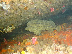 Horsefish
 Janbruin
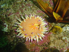 Violet spotted anemone
 Sunfish at Table Top pinnacle


Features
[edit]The main features of the Whittle Rock area are the varied and often spectacular granite formations. but there are a few artifacts worth a look if you pass them: There are several large anchors. The approximate positions are known for fifteen of them, and shown on the map. The positions of some are known with more precision. An asterisk indicates positions with unknown accuracy.
- 1 Kelly's Anchor A large iron anchor without a stock at about 32 m depth, on boulders and sand, north part of the main reef at S34°14.687' E18°33.612'.
- 2 Riaan and Sven's anchor* on the main reef, said to be about 20 m east of the mark at 18 m depth, at approximately S34°14.736', E18°33.592', described as unusually large.
- 3 Victor's chain A length of heavy open link mooring chain on the northeastern slope between The Shards and the Euphrates rise at a depth range of approximately 20 to 23 m. The chain lies roughly east–west, bridges several small gullies, and has a large, heavy, square steel plate with a central recess at one end, at S34°14.757' E18°33.692'. Length estimated about 57 m. This may be a mooring form one of the buoys which marked the rock. The chain is heavily encrusted and may not be easily noticed in some places.
- 4 September anchor A large iron anchor at 15 m depth, at approximately S34°14.767', E18°33.575' on the northwestern ridge of the main reef.
- 5 JJ's anchor* A large anchor with iron stock at 17 m depth, on the Euphrates Rise at estimated position S34°14.781', E18°33.721'.
- 6 Billy's anchor* A large anchor "much like the Euphtrates anchors" on the Euphrates Rise at estimated position S34°14.777', E18°33.734', at 19 m depth. This is quite close to JJ's anchor, so it is possible they are the same anchor, but far enough for doubt. More accurate survey and photos are needed.
- Three large iron anchors with iron stocks, thought to be from the English East-Indiaman Euphrates which struck the pinnacle and sank in 1810. All three are in the Euphrates Gully, on the Euphrates Rise , just north of the Eastern Pinnacle, as shown on the map. A fourth anchor thought to be from the Euphrates is reported from near this point, but the position is not known. All are between 24 m and 28 m deep. These anchors may not be from the Euphrates if the ship did not actually sink, as has been suggested by further research in 2024, however there are old divers who say they have seen copper sheathing somewhere on the reef, which would be evidence of a wooden ship at least striking the reef at some time.
- 10 Little anchor A smaller iron anchor on the main reef, at 18 m depth, at S34°14.785', E18°33.666'.
- 11 Marc's anchor* A large iron anchor without a stock lying flat at 14.5 m depth on the flat rock of the main reef at about S34°14.856', E18°33.716', near the 5 m pinnacle, and well camouflaged by encrusting growth. It probably does not have an iron or steel stock, or it would not lie flat, and so may be a relatively old anchor which had a wooden stock.
- 12 Bruce's anchor: S34°14.884' E18°33.687', a small steel anchor, firmly stuck in a small space between a few large boulders at the north side of the Eastern Sand Tongue at a depth of about 24 m. Not easy to see unless you swim right over it. Quite close to the edge of the sand.
- 13 South east pinnacle chain (Neptune's bath plug): S34°14.917' E18°33.753', a large, slightly dished, metal disc, somewhat less than a metre in diameter, with a central lug shackled to the end of a length of heavy chain, known as Neptune's Bathplug, on the sand on the north side of the big eastern sandy gully. Much of the chain is in a pile near the disc, which suggests that the disc sank at that point when the chain was already leading to the bottom and near vertical. The disc looks too small for the size of chain, and the wrong shape to have been intended as an anchor, but could have been a reinforcing plate under a large navigation marker buoy.
- 14 Georgina's anchor A large iron anchor at the base of the south slopes of the southeastern pinnacle, of unknown provenance, at a depth of 29 m, at S34°14.935' E18°33.784'.
- 15 Table Top anchor A small anchor at the base of the Table Top pinnacle on the southwest side, near the sandy strip, at approximately 26 m, at S34°14.971', E18°33.653'
Thwo other anchors have been reported. One is said to be near the three Euphrates anchors recorded as of 2020, between 27 and 30 m deep, and is also thought to be from the Euphrates. The other is somewhere at Stingray HQ, probably at about 25 m (82 ft) depth.
- Some of the anchors
 Wreckless divers at Kelly's anchor
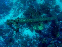 Kelly's anchor at the far north
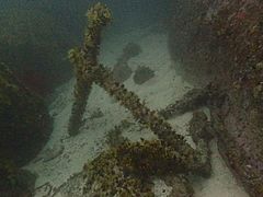 Anchor thought to be from the wreck of the Euphrates
 Bruce's anchor
 "Neptune's bathplug"
 Pile of heavy chain connected to "Neptune's bathplug"
 Georgina's anchor near the Eastern Pinnacle


Photography
[edit]This is a good site for photography. Macro is a safe bet, as there will always be subjects for close up work. If the visibility is good, and it can be better than 20 m occasionally, wide angle scenic shots are an option. Good visibility and good natural lighting together are relatively uncommon, so wider angle is better as you can get closer to large features. Most of the more topgraphically interesting reef is deep enough to be poorly illuminated most of the time.
Stay safe
[edit]Hazards
[edit]Cold water is possible. Strong winds may develop over a short time, particularly in summer. Great white sharks have been seen in this area. Poor surface visibility due to fog, rain, or spray, can occur occasionally, and if there is a surface current, a diver could drift quite a long way during ascent, making it difficult for the boat to find them. Fog can make it difficult for the boat to find divers after they surface, however, fog is usually associated with a lack of wind, so sound will generally carry very well. A whistle or an occasional loud sound could help establish direction to the diver, but it may be necessary to stop the engines occasionally to listen. The ride out is quite long and may be bumpy and wet. In winter the ride back seems even longer, particularly in a northwesterly wind, and wind chill can be a problem for a cold diver in a wet suit. On some occasions there may be large numbers of small craft fishing in this area, and some of the skippers do not pay much attention to where they are going.
Skills
[edit]Much of the reef is fairly deep and beyond the range of novice divers, but there are also extensive shallower areas. The ability to deploy a DSMB is recommended, as this will help the boat crew to see you after the dive, and will warn fishing boats of your presence while surfacing.
Equipment
[edit]A light is helpful both in deep areas to compensate for the loss of colour, and wherever there are deep cracks, overhangs and other dark areas. If there is an algal bloom near the surface, the deeper water will be quite dark even on a bright sunny day. A compass is mostly useful for heading towards a planned point, as when heading towards a shallower area at the end of a dive. An SMB is useful to help the boat keep track of your position, or to find you when you ascend. A DSMB is strongly recommended, and some skippers may require each dive team to carry at least one DSMB, and all divers to ascend on a marker, as it can be embarrassing to run over a surfacing diver on the way to pick up someone else, and being hit by the boat can ruin your entire day. A personal location transmitter beacon which sends a GPS position to all enabled VHF radios in the vicinity would improve the chances of a quick pick up in an emergency. Nitrox is generally useful to extend no-stop dive times as most dives at Whittle are fairly deep. The water temperature may be low, so good thermal insulation is also recommended. Divers using wetsuits in winter are advised to take some sort of windbreaker jacket. Even an unused plastic garbage bag with a head hole can make a big difference to comfort on a wet and windy day. If you want to dive solo, or rebreather, ask before booking, and you will be expected to provide evidence of competence, and have suitable equipment, which will normally include a bailout cylinder.
Read
[edit]- Diving the Cape Peninsula and False Bay#Read – A list of reference books on the ecology of Cape Town's waters and the geology of the Cape Peninsula.
- Whittle Rock at Wikipedia
Nearby
[edit]
Other offshore dive sites of False Bay:
- 1 SATS General Botha
- 2 Off-Whittle Ridge
- 3 Bruce's Mark
- 4 Western Deep
- 5 Midway Ridge
- 6 Sandy-top Ridge
- 7 Billy's Reef
- 8 Josh's Reef
- 9 Wreckless Ridge
- 10 Southwood's Corner
- 11 Lonehill Reef
- 12 Deep South Whittle Reef
Back to the Alphabetical list of sites, or list of reef dive sites in the Whittle Rock and surrounds offshore area
Other regional dive sites:
- Dive sites of Table Bay and approaches,
- Dive sites of the Cape Peninsula west coast
- Dive sites of the Cape Peninsula east coast
- Dive sites of False Bay east coast
- Fresh water dive sites of the Cape Town Metropolitan Area
