
Diving at Sandy-top Ridge

The dive site Sandy-top Ridge is an offshore rocky reef in the Whittle Rock area of False Bay, near Cape Town in the Western Cape province of South Africa.
Understand
[edit]
This is said to be a pleasant dive on a small but pretty reef, with enough area above 40 m to be worth diving on nitrox, and a fair amount of deeper reef along the sides.
Position
[edit]1 Sandy-top Ridge S34°15.153' E18°34.709'
Reef dive, boat access only. East of Whittle Rock and South of Bruce's Mark. A smallish granite outcrop rising from about 47 m on the sand to about 32 m deep at the flattish top, which has a sandy depression at the south end of the high reef. This site is not in a Marine Protected Area. A permit is not required.
Name
[edit]The name "Sandy-topped Reef" is descriptive of the unusual sand patch in a depression on top of the reef, about 10 m above the surrounding sand.
Depth
[edit]Maximum depth is about (depth) m. and the top of the reef is about (depth) m. Quite a large area is above 35 m. Average depth of a dive is likely to be about 40 m.
Visibility
[edit]Topography
[edit]The reef is a large granite outcrop with large boulders along the sides. The long axis is northwest-southeast, similar to other reefs in the vicinity. It is relatively long and narrow, with two areas of relatively high reef. The main area is to the northwest, where the top of the reef is at about 32m, and there is a depression or gully between the sides where sand has accumulated at about 36m depth, with ridges to both sides a few metres higher. The sand bottom around the reef is significantly deeper, at about 48m to the east. The east and south sides of this part of the reef have large chunky boulders, with deep cracks, crevices and some overhangs, and the top is more rounded and split by long cracks. Most of the reef remains unexplored. The southern section is deeper. The ridge tapers away gradually to the northwest and more bluntly to the southeast. Length is about 400?m and width about 80?m across the northwest section of high reef.
Geology: Pre-Cambrian granite of the Peninsula pluton.
Conditions
[edit]Get in
[edit]Boat access only. The site is about (distance)km from Simon's Town jetty, or (distance)km from Miller's Point
Do
[edit]Routes
[edit]There are no specific recommended routes, as the site is largely unexplored.
See
[edit]Marine life
[edit] Deepwater urchin
 Sponge
 Noble corals
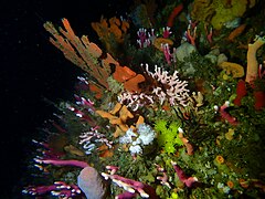 Reef life
 Shoal of juvenile maasbanker over the top of Sandy-top Ridge
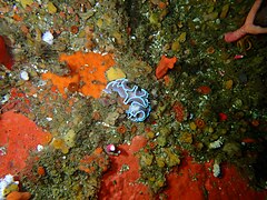 Frilled nudibranch
 Lacy false coral
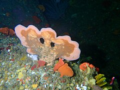 Sponge
 Sponge
 White cauliflower soft coral


Photography
[edit]Stay safe
[edit]Hazards
[edit]No site-specific hazards known.
Skills
[edit]Equipment
[edit]DSMB strongly recommended.
Nearby
[edit]
Other offshore dive sites of False Bay:
- 1 SATS General Botha
- 2 Off-Whittle Ridge
- 3 Whittle Rock
- 4 Bruce's Mark
- 5 Midway Ridge
- 6 Southwood's Corner
- 7 Josh's Reef
- 8 Wreckless Ridge
- 9 Lonehill Reef
- 10 Deep South Whittle Reef
Back to the Alphabetical list of sites, or list of reef dive sites in the Whittle Rock and surrounds offshore area
Other regional dive sites:
- Dive sites of Table Bay and approaches,
- Dive sites of the Cape Peninsula west coast
- Dive sites of the Cape Peninsula east coast
- Dive sites of False Bay east coast
- Fresh water dive sites of the Cape Town Metropolitan Area