
Diving at Castle Rocks

The dive sites at Castle Rocks and Parson's Nose are a group of inshore rocky reef areas in the Castle Rocks restricted area on the False Bay coast of the Cape Peninsula, near Cape Town in the Western Cape province of South Africa.
Understand
[edit]


These sites are good for fish and invertebrates, and in many places have spectacular topography. All are accessible as shore dives, but the shore access is not easy.
Position
[edit]1 Grassy patch between entry points: S34°14.353' E018°28.591'
This site is entirely inside the Castle Rocks Restricted Zone in the Table Mountain National Park Marine Protected Area (2004). A permit is required.
It is one of the best shore entry diving areas on the Cape Peninsula. The entries and exits are not the easiest, particularly in moderate to large swell, and the climb to and from the roadside requires reasonable fitness. The site requires some discretion and understanding of the sea conditions for safe entry and exit. Once in the water there is a bit of kelp to negotiate near the shoreline, but beyond that there is more topographic variety and biodiversity than in any other western False Bay dive site reasonably accessible from the shore.


Name
[edit]The name "Castle Rocks" applies to the point as a whole and the offshore rocks to the South East. The point is a small rocky peninsula that is nearly an island at high tide. The name also applies to the Marine Restricted Zone which stretches from Rumbly Bay, just south of Miller's point, to Baboon Rock, just south of Partridge Point. "Parson's Nose" refers to a small rocky point in the Castle Rocks South area.
Depth
[edit]The depth of the different sectors varies, but the maximum is probably about 18 m, with an average bottom depth nearer 10 m
Topography
[edit]Castle Rocks reef is a large contiguous area of shoreline and inshore granite reef around a small rocky peninsula and adjacent rocky islet. To the north the bottom is rocky, with granite boulders and bordered by a belt of sand from the shoreline out between Casle Rock and Pyramid reefs. This belt is about 350 m long and is parallel to the north coast of the Castle Rocks peninsula. The width varies from almost nothing in places to about 30 m, and it tends to be wider inshore, with a narrow section about halfway along. The bottom in this belt is fine sand inshore, and sand and pebbles further out. Further east is a series of big outcrops and boulders, some reaching almost to the surface, with gullies and gaps between. Beyond the point are large high profile parallel ridges and gullies running approximately north-south (010° magnetic). The bottom of the deeper gullies is sand with steep sided ridges between, of varied length, width and height. Further out the gullies are wider and the ridges shorter, but the general tendency is the same. Further out the reef thins out and there is more coarse shelly sand and the wave ripples may indicate a northerly wave direction.
Further to the south of this is a mixture of high and low ridges with sand bottomed gullies and gaps between them. Some are high, from the bottom at 14 m up to 7 m, others lower, down to less than a metre. These can be quite spectacular in good visibility.
The sandy bay visible from the roadside to the south of the point between the islet and the Parson's Nose promontory has a fine sand bottom sloping from about 2 m deep near the boulder beach entry to about 12 m at the southern extent of the reef south of the islet. The reef adjacent to the islet group are big granite ridges with some small to medium sized holes and tunnels, most of which are too small to enter, and one large swim-through. There are deep gullies at the back of the islet, and further south is flat fine sand bottom with small ripples and occasional widely spaced low rock outcrops. The small sandy beach south of the Parson's Nose marks the southern edge of the area.
Geology: Granite of the Pre-Cambrian Peninsula pluton, surrounded by sand.
Conditions
[edit]Usually considered to be a winter dive but there are also, occasional opportunities in other seasons. The site is well sheltered from north west wind and chop. Swell from the south west or south east will cause surge, and a strong south east wind will produce an uncomfortable surface chop which can make some of the exit areas difficult and may reduce visibility in a few hours. Judge by the conditions at the entry point and the colour of the water further out.
Facilities
[edit]None. Security at the parking area is said to be poor. Lock up your valuables where they can not be seen. The grassy patch at Castle Rocks is a pleasant spot for a picnic, but it may attract the attention of baboons.
Get in
[edit]Generally considered a shore dive. There is limited parking on the gravel shoulder on both sides of the main road (M4). The path to the shoreline starts at steps at the apex of the bend in the road and goes between the houses. If you are parked further north, the gravel access road also leads to the path.
The top of the path leading to the entry areas starts at the extreme left foreground of the photo. The path can be a bit slippery and is not all in good repair, but it is not a difficult climb for a fit person. There are entry and exit points north and south of the grassy patch.
North entry: It is often convenient to use the sheltered area inshore of the rounded rock ridge at S34°14'19.98" E018°28'35.92", in the middle of the picture, and to swim out round the left end of the rock. The ridge is roughly parallel to the shoreline, which provides a fairly sheltered little gully. In the centre background is Boat Rock, or Bakoven Rock, and the top of Pyramid rock can just be seen closer inshore to the left, beyond the kelp. This entry point can be used for dives to Shark Alley and Pyramid Rock, and anywhere on the North side of Castle Rocks. The boat just visible on the extreme right is probably anchored at Outer Castle. The north access depends to a large degree on tide and swell. Make your own decision after checking on site.
There is also an entry point right at the tip of the point on the north side at S34°14'20.62" E018°28'39.38'. To get there go towards the tall rocks and skirt them to the left until you reach a series of Red-bait fringed rocks. These drop off directly into quite deep water, but are not an easy exit, specially at low tide.
The south side has more options for entry. The rocky little beach nearest the road is generally usable. The photo shows the entry and exit point most popular on this side, which is right beside the large rock in the middle left of the photo. Stay to the seaward side close in to the high ridge at S34°14'22.43" E018°28'35.95" for exits. The gully to seaward of this ridge is deceptive and can be an unpleasant exit if a wave catches you as the surge can be strong.
You can use the large flat topped Black rock further to seaward at S34°14'22.84 E018°28'38.25" for entry and exit if it suits your dive plan. The top of this rock is almost black, and can be slippery when wet, however it is reasonably flat, and there is a convenient crack and ledge to help get back on if the tide is not too low.
All these shore access areas require walking over irregular rocks and boulders, some of which may be loose.
 Castle Rocks seen from the roadside.
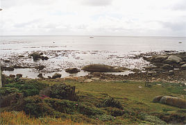 The north entry at Castle Rocks.
 South entry and exit area


Do
[edit]Dive at one of the listed areas, or follow one of the routes.
2 North Castle: S34°14.322' E018°28.650'. This area has a fairly shallow rocky bottom with granite boulders and outcrops of moderate height near the entry point. Further east is a series of big outcrops and boulders, some reaching almost to the surface, with gullies and gaps between. Around the point there are a ridges and gullies running more or less north-south. Along the north side about 20 m off the big boulder with two vertical cracks, there are two entrances to a swim-through at about 9 m depth, which can be found by following the edge of the kelp zone. The swim-throughs join under the boulders and split into three exits, to the left, sloping upwards, in the centre sloping upwards and to the right into a hole surrounded by boulders. Use the north entry, swim out a few metres, descend and follow the coast toward the point in the kelp forest. As you approach the point, look out for the swim-through. Continue round the point and either return by the same route, or make your way through the gap between the point and the offshore rocks to the south.
3 Point Reefs: S34°14.400' E018°28.800'. Also known as Outside Castle (but not Outer Castle, which is part of the Pie Rock reef, somewhat further offshore): This is a large area of roughly parallel ridges and gullies, running approximately north-south (010° magnetic). The bottom of the deeper gullies is sand with steep sided ridges between, of varied length, width and height. Further out the gullies are wider and the ridges shorter, but the general tendency is the same. Further out the reef thins out and there is more coarse shelly sand and the wave ripples may indicate a northerly wave direction. Further to the south of this is a mixture of high and low ridges with sand bottomed gullies and gaps between them. Some are high, from the bottom at 14 m up to 7 m, others lower, down to less than a metre. These can be quite spectacular in good visibility. There are no particular routes. Entry at the black rock, swim out through the gap and explore. Return to the entry point for exit.
4 Castle Pinnacles: S34°14.356' E018°28.826' — A group of fairly tall pinnacles along the edge of the sand. One of them has a large swim-through under it. The Castle Pinnacles area is part of Pyramid Rock reef, but as a shore dive the entry is usually at Castle Rock, and it was named before the area was surveyed. This area is best dived in good conditions as the mood is then excellent. In autumn there are often large assemblies of fish, including schools of Roman, Bank Steenbras and Fransmadam. In winter, when the water is colder, there are fewer fish, but the whole area looks impressive in the better visibility. Enter at the tip of the point on the north side. Descend and swim out to the north across the sand strip, then follow the edge of the sand to the west until you find the pinnacles. Return by compass or natural navigation to the gap and exit at the black rock. The course from the swim-through pinnacle to the gap is 282° magnetic for about 250 m. Maximum depth on the sand is about 15 m. First described by Guido Zsilavecz, although probably already known in the 1980s.
5 Inner Castle: S34°14.460' E018°28.674'. South Side, or Inner Castle, is the sandy bay visible from the roadside to the south of the point. There is fine sand bottom sloping from about 2 m deep near the entry to about 12 m at the outside of the large rock group to seaward of the sand patch. This group is big granite ridges with some small to medium sized holes and tunnels, most of which are too small to enter. There are deep gullies at the back of the offshore rocks, and further south is flat fine sand bottom with very small ripples and occasional widely spaced low rock outcrops. There is a deep, fairly wide rocky bottomed gully running south from near the south end of the islet rock group, which is roofed by a huge boulder near the south end to form a spacious swim-through. Concentrate on the boulders and reefs to the south of the point. The sandy bottom of the south cove can be interesting if there is not too much surge, which tends to pick up the fine sand and detritus and reduce the visibility. This area is where you may see sole and sand sharks, and near the boulders, snakelets, Platanna klipfish and Leprous platanna klipfish.
Routes
[edit]Grand Tour: For the active swimmer, the rebreather diver, or the diver with large cylinders, it is possible to work your way through all these areas on a single dive, entering at the north entry and exiting at the rocky beach, or the reciprocal route.
See
[edit]Marine life
[edit]There is a belt of heavy Red-bait growth fairly close to the surface, and below this there is a zone where sea urchins dominate, particularly on near horizontal surfaces. There are fairly dense kelp forests in the north entry area, between the point and the southern rocks and on the submerged rocks between the southern rocks and the mainland. In the deeper reef areas there is often a dense cover of feather stars and sometimes red sea cucumbers. This is a site well known for variety and size of fish and a diversity of invertebrates. Sometimes even a whale.
 Blue spotted klipfish
 The seldom seen Robust klipfish
 Deep reef klipfish
 Juvenile Baardman
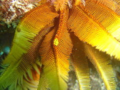 Myzostomids on Elegant feather star
 Encrusting sponges, ascidians and algae


Features
[edit]The swim-through pinnacle at S34°14.363' E018°28.820' in the Northern Pinnacles part of the site is a group of large outcrops capped with a large flattish boulder. There are two distinct and spacious swimthroughs under this pinnacle from the sand tongue more or less north east onto the reef.
Photography
[edit]The site is good for fish and invertebrate photography. Almost any camera setup will be usable if conditions are good, but macro and wide angle arrangements with external strobes will usually be most versatile.
Stay safe
[edit]Hazards
[edit]No special hazards other than those associated with shore access at the sites.
Skills
[edit]The Southern part of Castle Rocks includes the group of large rocks in the middle right of the photo. The water inshore of these rocks is fairly sheltered and has a sandy bottom with scattered rock outcrops where the kelp is visible. This is a popular training area for entry level divers, and is also suitable as a base point for night dives.
A moderate level of fitness and agility is required for shore access at these sites.
Equipment
[edit]No special equipment is required. A light is useful for looking into dark holes and overhangs and for restoring colour loss due to depth. A compass can help you to keep track of your position and is useful for finding your way back underwater and at night.
Nearby
[edit]
- 1 Miller's Point tidal pool
- 2 Murphy's
- 3 Boat Rock
- 4 Festival Pinnacle
- 5 Fan Reef
- 6 Shark Alley
- 7 Pyramid Rock
- 8 Phone reef
- 9 Super Fan Reef
- 10 Outer Castle
- 11 Giant's Castle
- 12 Zigzag Reef
- 13 North Pie Rock Reef
- 14 West Pie Rock Reef
- 15 East Pie Rock Reef
- 16 South Pie Rock Pinnacles
Back to the Alphabetical list of sites, or list of dive sites in the Castle Rocks area
Other regional dive sites:
- Dive sites of Table Bay and approaches,
- Dive sites of the Cape Peninsula west coast
- Dive sites of False Bay offshore and approaches
- Dive sites of False Bay east coast
- Fresh water dive sites of the Cape Town Metropolitan Area