
Diving at Dreadlocks Reef

The dive site Dreadlocks Reef is an offshore rocky reef in the north Oudekraal area on the Atlantic Seaboard of the Cape Peninsula, near Cape Town in the Western Cape Province of South Africa.
Understand
[edit]
The site is colourful and fairly spectacular, and is specially notable for the relatively large colonies of the Dreadlocks hydroid Myriothela tentaculata. The depth is suitable for entry level divers.
Position
[edit]- 1 Dreadlocks Pinnacle: S33°58.3675' E18°21.709833' — (Top of pinnacle)
This site is in the Table Mountain National Park Marine Protected Area since 2004. A permit is required.
Name
[edit]


The site was named "Dreadlocks Reef" after the Dreadlocks hydroids found there in unusually large numbers.
Depth
[edit]Maximum depth is about 20 m. and the top of the pinnacle is about 1.5 m deep at low tide. (Average depth is likely to be about 12 to 15 m)
Visibility
[edit]Visibility will depend on weather conditions, and may be in excess of 15 m on a good day after an offshore wind and upwelling.
Topography
[edit]Large corestone ridge with low surrounding reefs. The pinnacle is quite pointy, and the tip is only a couple of metres across. Ridge axis bearing 300°T (324° magnetic), ridge length 50 m and width 20 m at 12 m deep. Length at bottom about 100 m, width not known, but probably about 40 m at widest. There is a smaller pinnacle a few metres to the south about 10 m diameter at 12 m depth.
The SAN charts indicate another high reef about 200 m to the north-east of Dreadlocks pinnacle, but this has not yet been mapped.
Geology: Pre-Cambrian granite of the Peninsula pluton.
Conditions
[edit]The site is exposed to westerly winds and swell.so should be dived in calm or offshore winds, when the swell is low, and is often good in South Easterly winds. The site is reasonably protected from easterly seas.
The site is usually at its best in summer but there are also occasional opportunities at other times of the year.
This is an area which sometimes has upwellings of clear cold water, caused by offshore winds, resulting in good visibility and low temperatures, sometimes followed by algal blloms which will reduce the visibility again.
Get in
[edit]Usual access is by boat, but it could be dived from the shore by very fit divers in good conditions. The shortest distance to the shoreline is about 620 m, but this may not be a suitable point for entry and exit.
The site is about 12 km from the Oceana Power Boat Club slipway at Granger Bay, or 16,4 km from Hout Bay harbour.
See
[edit]Marine life
[edit]The upper regions are covered in the usual large red-bait pods, and there is a light growth of kelp above about 12 m depth. Lower areas are encrusted by sponges, colonial ascidians, sea fans, anemones, small red algae, crustose corallines, hydroids, bryozoans and echinoderms. The flatter deep reefs are heavily covered by sea cucumbers and sea urchins. Small shoals of Hottentot seabream can be expected. A variety of nudibranchs and other gastropods can be found.
 Multicolour sea fans Melithaea rubra
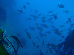 Shoal of Hottentot seabream
 Tubular sponge


Photography
[edit]Macro photography is likely to yield good results, and if the visibility is good, wide angle scenic shots should also turn out well.
Suggested Routes
[edit]The site is not very large: Start by going down to the bottom of the ridge, and swim round it looking for Dreadlocks colonies, then continue round as you ascend, and do your safety stop at the pinnacle if conditions allow.
Stay safe
[edit]Hazards
[edit]No known site specific hazards
Skills
[edit]No special skills required for boat dive.
Equipment
[edit]A dry suit or 7 mm wet suit is recommended, as it will usually be cold. If visibility is not very good a DSMB will help the boat find you when you ascend.
Nearby
[edit]
- 1 Bakoven Rock
- 2 Geldkis Blinder
- 3 Strawberry Rocks
- 4 Geldkis
- 5 Het Huis te Kraaiestein
- 6 Mushroom Pinnacle
- 7 Sandy Cove
- 8 Boardroom pinnacle
- 9 Justin’s Caves
- 10 Antipolis
- 11 Klein Pannekoek
- 12 Groot Pannekoek
- 13 Coral Gardens
- 14 Coral Gardens Offshore Pinnacle
- 15 13th Apostle
Back to the Alphabetical list of sites, or list of dive sites in the Oudekraal area
Other regional dive sites:
- Dive sites of Table Bay and approaches
- Dive sites of the Cape Peninsula east coast
- Dive sites of False Bay offshore and approaches
- Dive sites of False Bay east coast
- Fresh water dive sites of the Cape Town Metropolitan Area