
Diving at Mushroom Pinnacle

The Dive site Mushroom Pinnacle is a small part of the inshore rocky reef in the north Oudekraal area on the Atlantic seaboard of the Cape Peninsula, near Cape Town in the Western Cape province of South Africa.
Understand
[edit]
The pinnacle is a submerged granite tor (stacked group of large corestones) between Geldkis and Justin’s Caves. Access is relatively easy, and this is a good site for macro photography.
Position
[edit]- 1 Mushroom Pinnacle: S33°58.781’ E018°21.521’ — (Top of the pinnacle)
Bearings:
- 74° magnetic to Geldkis near end
- 155° magnetic to NW edge of Sandy Cove point rocks
- 246° magnetic to the offshore edge of Justin’s group
- 216° magnetic to the inshore edge of Justin’s group
This site is in the Table Mountain National Park Marine Protected Area since 2004. A permit is required.
Name
[edit]The name "Mushroom Pinnacle" was given by one of the first divers to popularise the site, and refers to the spreading overhangs reminiscent of fungal growths (admittedly requiring a bit of imagination, or not very good visibility.)
Depth
[edit]Maximum on the adjacent reef about 16 m, top of pinnacle about 3 m, 17 m at sand patch nearby.
Topography
[edit]
Granite corestone boulders and outcrops. Spectacular pinnacle rising to within 3m of surface, with fairly flat top. The main rock is probably more than 10 m high and about the same in other dimensions. The pinnacle rock rock lies on a lowish outcrop and a higher one, with a low and fairly cramped swim-through between. There are a number of smaller boulders and outcrops around the pinnacle group, which would be an amazing sight on a really clear day. There is a big overhang near the top and even bigger overhang about 5 m by 3 m with an air trap below it at about 9 m which shelters a vertical face with a rich encrustation of sponges, corals and other invertebrates, both on north side. There is a fairly big cave/tunnel with 5 openings under the top rock from south to north, but lots of fragile organisms live in it, so do not go through as openings on the north side are quite low and you are likely to damage the corals, sponges and bryozoans. The pinnacle is surrounded by other granite reef of lower profile, which extends to Justin's caves to the south west.
Geology: The reef is granite of the late Pre-Cambrian Peninsula pluton, and is surrounded by fine white quartz sand.
Conditions
[edit]Usually at its best after south easterly winds in summer but there are also occasional opportunities in autumn and early winter on windless days when the swell is low and short. Strong south easterly winds (offshore) can make it difficult to swim back to shore on the surface.
The site is exposed to westerly swells, which may produce strong surge and poor visibility
This is an area which sometimes has upwellings following a strong south east wind, which can produce clear but cold water
Facilities
[edit]There are no facilities provided. Security of parked vehicles is no better than at other roadside sites.
Get in
[edit]Generally a shore dive. Park at side of road on outside of bend on City side of Twelve Apostles Hotel. An entry and exit point which is protected from the South West swell is at Sandy Cove. Alternatively the entry point for Justin’s Caves can be used – the distance to swim is shorter, but there may be more kelp to negotiate, particularly at low tide, and the path to the entry point for Justins is more rocky and slippery.
If done as a boat dive, the distance is slightly less from Oceana Power Boat Club slipway than from Hout Bay.
See
[edit]Marine life
[edit]Very colourful growth of invertebrates under the lower overhang, on vertical sides and in swimthroughs. These house a good variety of nudibranchs and a few species of cryptic klipfish, including the blue-spotted and speckled klipfish. A small kelp forest on top of the pinnacle helps with finding it, as the kelp is visible from the surface. Bobtails (a variety of tiny squid-like cephalopod) are sometimes seen over the sandy patches between the point and the pinnacle. There is usually a large school of hottentot on the northern corner of the pinnacle, near the two overhangs.
 Cuttlefish
 Noble corals
 Sponges
 Sponges
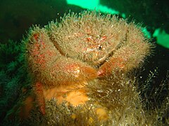 Sumo crab in the cave


Features
[edit]Huge rock standing almost alone among lower outctops, with cavern under it and two ledge overhangs on one side.
Photography
[edit]A good site for macro photography.
Routes
[edit]Use the entry at Sandy Cove. Swim out between Geldkis and Justin’s to top of the pinnacle. Find it by using GPS or bearings from Geldkis, Justins and shore rocks. Confirm that you are over a large rock at about 2 to 3 m depth with kelp on top, and dive. Do note that closer inshore there are a few other pinnacles with which this one may be confused. These pinnacles have more kelp growing on them, and are far less spectacular than the mushroom pinnacle. The site is compact, and it is not important in what order you visit the features, as it is not particularly deep, and most of the interesting areas are at much the same depth anyway. Be sure to visit the deep overhang and the cave, which are on opposite sides of the pinnacle.
Return to Sandy Cove on bearing 155° magnetic, and when you reach the point rocks, keep them to your right on the way back to the cove.
If you have a lot of time over, you can continue the dive at Justins Caves, on bearing between 216° and 246° magnetic.
Stay safe
[edit]Hazards
[edit]Cold water, Sea urchins, Strong offshore winds may develop over a short time.
Skills
[edit]No special skills are required, other than the ability to find a position using compass bearings. For a shore dive a fair level of fitness is required as there is a long swim to and from the site. Ability to navigate back by compass is recommended, particularly if there is offshore wind forecast
Equipment
[edit]A light is recommended for looking into caves and overhangs, and because of the loss of colour at depth. A compass is strongly recommended for shore dives and the return should be done underwater if the wind picks up during the dive.
Nearby
[edit]
- 1 Bakoven Rock
- 2 Dreadlocks Reef
- 3 Geldkis Blinder
- 4 Strawberry Rocks
- 5 Geldkis
- 6 Het Huis te Kraaiestein
- 7 Sandy Cove
- 8 Boardroom pinnacle
- 9 Justin’s Caves
- 10 MV Antipolis
- 11 Klein Pannekoek
- 12 Groot Pannekoek
- 13 Coral Gardens
- 14 Coral Gardens Offshore Pinnacle
- 15 13th Apostle
- 16 Logies Bay
Back to the Alphabetical list of sites, or list of dive sites in the Oudekraal area
Other regional dive sites:
- Dive sites of Table Bay and approaches
- Dive sites of the Cape Peninsula east coast
- Dive sites of False Bay offshore and approaches
- Dive sites of False Bay east coast
- Fresh water dive sites of the Cape Town Metropolitan Area