
Pontiac

Pontiac is a city in Oakland County, Michigan, and a satellite city of Detroit.
Get in
[edit]
Map of Pontiac (Michigan)
By train
[edit]- See also: Rail travel in the United States
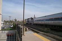
The Detroit Amtrak station

- 1 Pontiac station, 51000 Woodward Ave.


- Amtrak, ☏ +1 215-856-7924, toll-free: +1-800-872-7245. Operates train service around the United States of America. Route serving Jackson:
- Wolverine Service operates several times daily between Pontiac and Chicago including stops along the way in Troy, Royal Oak, Detroit, Dearborn, Ann Arbor, Jackson, Battle Creek, Kalamazoo, Niles, and New Buffalo. There are many train connections in Chicago.
- Amtrak, ☏ +1 215-856-7924, toll-free: +1-800-872-7245. Operates train service around the United States of America.
Get around
[edit]See
[edit]- 1 Pine Grove Historical Museum, 405 Cesar E Chavez, ☏ +1 248-338-6732, office@ocphs.org.
- Creative Arts Center, 47 Williams St, ☏ +1 248-333-7849, PCACdirector@gmail.com.
Do
[edit]Buy
[edit]Eat
[edit]Drink
[edit]- 1 The Crofoot, 1 S Saginaw St, ☏ +1 248-858-9333. Live music venue.
Sleep
[edit]- 1 Courtyard by Marriott Detroit Pontiac/Auburn Hills, 3555 Centerpoint Pkwy, ☏ +1 248-858-9595.
- 2 Marriott Auburn Hills at Centerpoint, 3600 Centerpoint Pkwy, ☏ +1 248-253-9800. modern quality comfortable accommodation
Connect
[edit]Go next
[edit]| Routes through Pontiac |
| Detroit ← Troy ← | W |
→ END |
| Ends at |
N |
→ Bloomfield Twp → Ends at |
| Ends at |
N |
→ Bloomfield Twp → Detroit |