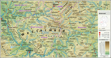
Westerwald is a low mountainous region in Germany which encompasses parts of Hesse (Hessen), Rhineland-Palatinate (Rheinland-Pfalz) and North Rhine-Westphalia (Nordrhein-Westfalen).
Cities
Other destinations
Understand

Bordered to the south by the Lahn Valley and the Taunus and to the west by the Rhine facing the Hunsrück and Eifel.
Get in
By train
Long-distance trains
Long distance trains stop at the stations Koblenz Hbf, Montabaur, Limburg Süd, Siegburg/Bonn and Bonn Hbf.
Local trains
- RB 23 Limburg(Lahn) - Diez - Bad Ems - Koblenz Hbf - Andernach - Mayen Ost
- RE 25 Gießen - Weilburg - Limburg(Lahn) - Diez - Bad Ems - Koblenz Hbf
- RB 45 Fulda - Alsfeld - Gießen - Weilburg - Limburg(Lahn)
- RB 90 Limburg(Lahn) - Diez Ost - Westerburg - Hachenburg - Altenkirchen - Betzdorf(Sieg) - Siegen
- RB 95 Siegen - Haiger - Dillenburg
- RB 96 Betzdorf(Sieg) - Herdorf - Haiger - Dillenburg
- RB 97 Betzdorf(Sieg) - Daaden
- RE 99 Siegen - Dillenburg - Wetzlar - Gießen - Frankfurt Hbf
By plane
Nearest airports are Frankfurt (FRA IATA), Cologne/Bonn (CGN IATA), and Hahn (HHN IATA)
By bus
Stations of intercity busses are in Frankfurt (near centralstation, exit south/Stuttgarter Straße), Cologne/Bonn (at the airport, at the central station, exit Breslauer Platz and trainstation Leverkusen-Mitte) Koblenz (near centralstation).
Get around
See
Do
- Westerwald-Steig 235 km (146 mi) marked walk.
Buy
Eat
Sleep
Go next

