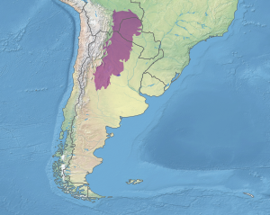
The Argentinian Chaco is a region in the north of Argentina. It is the Argentinian portion of the Chaco, a South American region that includes parts of Argentina, Paraguay, Bolivia, and Brazil. In Argentina, the Chaco is bordered by Paraguay and Bolivia in the north and by the Mesopotamia region in the east, by the Pampas region in the south, and by the Andean Northwest region in the west. In Argentina, the Chaco includes part of the provinces of Chaco, Córdoba, Formosa, Salta, Santa Fe, Santiago del Estero, and Tucumán.
Cities
[edit]Other destinations
[edit]If you like canoeing, you can sail the Bermejo or Pilcomayo rivers and the White Lake.
There are also aboriginal communities, like Pilaga, wichi, guaraní and chiriguano, which can be visited by tourists. Women produce excellent crafts, tapestry, basketmaking, wood carving, pottery, etc.
National parks and reserves
[edit]- Parque Nacional Rio Pilcomayo, near Clorinda, is worth a visit.
- Reserva Natural Formosa, in the extreme west of the province near Ingeniero Juarez.
- Bañado La Estrella, a wetland near the Pilcomayo river, with lots of colorful birds. Best accessed with a guide or tour operator. It is home to a lot of animals and plants. You can sail or sail in it surrounded by alligators.
Understand
[edit]Formosa Province has a population of 530,000. The province still consists partially of impenetrable forest where pumas, jaguars, alligators, and deer roam. The flora is very colorful, and includes many varieties of orchids. Unfortunately, some of the former quebracho tree forests have given way to large cotton plantations. Although the inhabitants refer to the interior as monte (mountain), the whole province territory is mostly flat. Some aboriginal tribes from the Chaco still live in communities in the interior of the province.
Climate
[edit]Formosa has a tropical climate. Winter is the dry period, which can last up to six months, at the end of which the rain comes down like a tropical deluge. Summer can be extremely hot with temperatures rising to 50°C (120°F). The best time to visit Formosa is during the winter months of June, July, and up to mid-August.
Get in
[edit]Get around
[edit]While not connected to the national passenger railway network, Trenes Argentinos operates a few commuter lines within the state. There are 1-3 departures every day and the train can be useful for reaching some smaller towns.


