
Diving the MFV ''Orotava''

The dive site MFV Orotava is a recent wreck in the Smitswinkel Bay area on the Cape Peninsula side of False Bay, near Cape Town in the Western Cape province of South Africa.
Understand
[edit]

.jpg)
Like the other wrecks of Smitswinkel Bay, the MV Orotava is reasonably accessible and a popular dive site for both local and visiting divers. The dive is moderately deep, but within the comfort range for many recreational divers, and the area is fairly well protected from the prevailing swell. The depth also protects the wrecks from the worst of the storm surge which would otherwise have broken them up much sooner. The Orotava is one of the better preserved wrecks of the Cape Peninsula, and is small enough to be fairly comprehensively visited on a single dive.
Position
[edit]The MFV Orotava is the second from northernmost of the 5 wrecks in Smitswinkel bay.
This site is in a Marine Protected Area (2004). A permit is required.
Name
[edit]The "MFV Orotava" was built in 1958 by Cook, Welton and Gemmel Ltd, of Beverly, East Yorkshire. The steel trawler was donated to the False Bay Conservation Society along with the MFV Princess Elizabeth by Irvin and Johnson. In August 1983 the vessels were towed out to Smitwinkel Bay and were scuttled.
| Displacement | 1060 | tonnes | |
| Length over all | 50 | m | |
| Beam | 9 | .1 | m |
| Draft | 5 | m | |
| Engine power | 1250 | BHp | |
| Crew | 24 |
Depth
[edit]Sand bottom is at about 32 m near the stern, Gunwales 25 m to starboard on the quarterdeck, to 27 m forward of the wheelhouse to port. Highest point on the wreck about 23 m at the top of the funnel.
Visibility
[edit]The visibility on the wrecks in Smitswinkel Bay is often better than at sites closer inshore and shallower. This may be due to less water movement at depth. Visibility on a good day may be more than 10 m, and on exceptional occasions has been more than 20 m, but do not be too disappointed if it is no more than 6 to 8 m.
Topography
[edit]The Orotava is the larger of the two trawlers and lies on the sand at about 34 m. The highest part of the wreck is the top of the funnel at about 23 m (2005). The vessel has an asymmetrical superstructure with the enclosed part offset to port and a covered walkway on the starboard side. The wreck lies heeled to port at an angle of about 20°, and is (2012) still in almost intact condition, with very little wastage of shell plating. There is a long raised quarterdeck, with a smaller wheelhouse structure and funnel forward, with the wheelhouse roughly amidships. A small rectangular structure towards the stern of the quarterdeck was present until late 2023, but had gone by May 2024, leaving a rectangular hole through the deck.
The front and top of the wheelhouse are gone, leaving the upper superstructure open all the way to the back, where there is a hole below the funnel into the space above the engine room, which is also accessible via the engine room skylight. The top of the funnel now functions as a skylight for this part of the superstructure, but the frames are too close for use as an access point.
There is a large winch on the waist deck just forward of the superstructure, and a pair of hatches ahead of this give reasonable access to the hold space, which is clear, but cluttered by pillars, which were used to support washboards to control the cargo. There are several holes in the sides and upper deck where plating has rusted away leaving only the frames, which are probably too tight for most divers to exit. The base of the mast is roughly in line with the shelter deck on the port side, just aft of the forecastle, and on the starboard side is a trawl gallows, supported by struts.
The forecastle is accessible at main deck level trough a spacious opening at the break, and inside there is a hatch down into a hold, which appears to be accessible, though a perhaps little tight for back mount. This hold contains little of interest, it is virtually empty. The forecastle space is quite open and reasonably clear except for a large number of pillars. There is a small manhole to a cofferdam which is too small for diver access, and in any case you can see the whole compartment from outside. There is an anchor winch on top of the forecastle.
There is a fairly large skylight on the quarterdeck just abaft the funnel, which has lost the cover on the starboard side, and the hole is big enough to provide comfortable access for most divers. This opens into a space above the engine room, and there is a hole directly below which takes you the rest of the way down directly above the engine block. A shaft tunnel is visible behind the engine, which looks fairly tight. The engine room is fairly cluttered, but reasonably clear above the engine.
Geology: The bottom of the bay is flat white sand. There is no reef in the immediate vicinity.
Conditions
[edit]The site is exposed to swell from the south east, and to a certain extent, from the south west. Longer period swell will make conditions on the wrecks uncomfortable or hazardous due to strong surge, but short period waves will just make it uncomfortable on the boat. Visibility is less predictable, and at this time is largely a matter of luck and reports from divers who were in the area recently.
The site is usually at its best in winter but there are also occasional opportunities at other times of the year, though least often in summer, when the south east wind tends to blow much of the time.
Get in
[edit]This site is only accessible by boat. It is about 5.1 km from the slipway at Miller's Point and 12.4 km from Simon's Town jetty.
See
[edit]Marine life
[edit]The wreck is too deep for much seaweed, but it is heavily encrusted with invertebrates, some of which are seldom seen anywhere else but the Smits wrecks. There are large numbers of multicolour and other sea fans, large clusters of sea cucumbers and areas covered with strawberry anemones. The Frilled nudibranch and the Gas flame nudibranch are common. Barred fingerfin are possibly the most common fish, but others, including scorpion fish, white seacatfish, panga, two-toned fingerfin, klipfish and horsefish may be seen.
 Feather stars
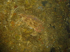 Scorpion fish
 Two tone fingerfin
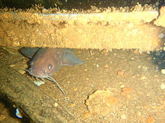 White seacatfish in the hold
 Whelks with an egg mass
 Frilled nudibranchs


Features
[edit]Fairly intact wreck of steel side-trawler. The low funnel and stub mast on the superstructure are the highest points on the wreck. There is a large and easily recognisable winch on the foredeck just forward of the superstructure. The front of the wheelhouse is missing and you can swim into the superstructure from the forward end above the winch. The engine room is accessible for the appropriately skilled and equipped diver, and some of the machinery is in place.
 Inside the Orotava
 Diver framed by the propeller aperture
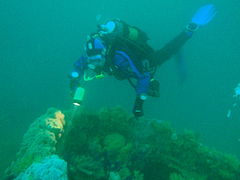 Diver over the funnel
 Diving the Orotava - starboard side
 Looking back out from inside the forecastle
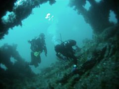 Divers in the wheelhouse
.jpg)


Photography
[edit]There are plenty of macro subjects, but in good visibility a wide angle or fisheye lens will give some interesting views
Routes
[edit]No particular route recommended. Penetrations are tight and limited due to the size of the vessel.
Stay safe
[edit]Hazards
[edit]Scorpion fish have been seen on the wrecks, and are well camouflaged. Their spines carry a dangerous venom. The interior of the wreckage has deposits of fine silt, and visibility may be drastically reduced if this is kicked up, making it difficult to orientate within the wreck and this may hinder a diver from finding the way out.
Skills
[edit]Certification appropriate to the depth is expected. Some level of training or experience in wreck diving is recommended, and penetration should only be attempted by suitably competent divers after reconnaissance and appropriate planning.
Equipment
[edit]Equipment appropriate for the depth should be used. Nitrox is recommended for those competent to use it. A light is strongly recommended, and penetration should not be attempted without the appropriate equipment and planning. If you are not entirely certain what this would be, you are not competent to do the penetration.
Nearby
[edit]
- 1 SAS Transvaal
- 2 Good Hope Reef
- 3 MFV Princess Elizabeth
- 4 SAS Good Hope
- 5 MV Rockeater
- 6 Smits Cliff
- 7 Smits Reef
- 8 Batsata Rock
Back to the Alphabetical list of sites, or list of dive sites in the Smitswinkel Bay area
Other regional dive sites:
- Dive sites of Table Bay and approaches,
- Dive sites of the Cape Peninsula west coast
- Dive sites of False Bay offshore and approaches
- Dive sites of False Bay east coast
- Fresh water dive sites of the Cape Town Metropolitan Area