
Diving at Rambler Rock

Rambler Rock is a cluster of offshore rocky reefs in the Simon's Town area on the Cape Peninsula side of False Bay, near Cape Town in the Western Cape province of South Africa. It includes several sections of reef, such as the North-west pinnacle, the North Central Reef, the North-east reefs, the Southern pinnacles and surrounding reef, and the small reef section at Hotlips pinnacle. Several other patches of reef in this area have not yet been surveyed or named. If they have been dived, no-one has recorded them.
Understand
[edit]

The North-west pinnacle is particularly scenic in good visibility.
Position
[edit]- 1 Rambler Rock North-west Pinnacle: S34°10.924’ E018°27.899’
- 2 Rambler Rock North-central Reef: S34°10.930’ E018°27.930’ Approximately central.
- 3 Rambler Rock North-east Reefs: S34°10.916' E018°27.996'
- 4 Rambler Rock Southern Pinnacle: S34°11.011’ E018°27.918’
- 5 Hotlips Pinnacle: S34°11.145' E018°28.091'
A group of reefs south east of the Roman Rock lighthouse off Simon’s Town Harbour. It is marked on the SAN charts which show two major groups of rocks at this site: the north group and the south group. There are several patches of reef in each group, and the ones that have been mapped are listed here.
This site is in a Marine Protected Area (2004). A permit is required. It is outside (east) of the Boulders Restricted Zone.
Name
[edit]The reef is marked on the SA Navy charts as "Rambler Rock".
Depth
[edit]- Maximum depth about 22 m on the sand at the North-west pinnacle. Top of the pinnacle is about 10 m.
- Maximum depth at the North-eastern reefs is about 27 m on the sand. The top of this section is at about 14 m.
- The central northern reef is fairly flat. Most of it is above 24 m and below 21 m.
- The Southern reef has pinnacles rising to a bit above 9 m, and the surrounding sand can be as deep as 26 m to the east.
- The far south-eastern reef Hotlips pinnacle has sand bottom at 30 m to the east, and rises to a fairly flat-topped pinnacle at between 18 and 21 m.
Visibility
[edit]Visibility is difficult to predict, and may differ from sites further inshore (usually better) and further south (may be better or worse). When conditions are generally good for this area it may be in excess of 10 m, more commonly a bit less.
Topography
[edit]This area has several separate areas of reef, some close enough together to be visible across the sand between them, others further apart, but they are all known as the Rambler Rock reefs. It is not even clear which is the nominal Rambler Rock, though only the North-west pinnacle and the bigger reef with the Southern Pinnacles seem reasonable candidates, because of their depths.
North-west Pinnacle is high and compact, while Southern Pinnacles is massive and spread out. The North-east reefs are deeper and moderately compact, the North central reef is spread out and relatively low. Hotlips is a bit of an outlier – its pinnacle area is quite a long way from the others – but sonar images show almost continuous reef between them and the southern sector, so they are grouped together for now.
Geology: Granite corestone outcrops and boulders of the late Pre-Cambrian Peninsula pluton.
Conditions
[edit]This site can be dived at any time of the year that has low or short period swell. Poor visibility at the surface does not necessarily extend to the bottom. The site is exposed to winds from all directions, which can produce an unpleasant choppy sea, and make it difficult for the boat crew to see a diver on the surface. The site is usually at its best in winter and spring, as it is well sheltered from westerly swells.
Get in
[edit]This site is only accessible by boat. It is about 3.9 km from Simon's Town jetty or 5.4 km from Miller's Point slipway.
Do
[edit]Dive at one of the drop points and explore the reef in that vicinity, or follow a suggested route.
6 Rambler Rock North-west Pinnacle: S34°10.924’ E018°27.899’. A pinnacle of very large boulders and outcrops concentrated in an area about 25 m diameter. The top of the pinnacle is at about 11 m depth. The pinnacle is surrounded by scattered small low boulders and outcrops over a larger area (About 75 m East to West, 35 m North to South), on a coarse sand bottom, at a depth of just over 24 m. Some nice gullies, crevices, overhangs and holes in the deeper areas. Particularly colourful on vertical and overhanging areas, and the topography is fairly spectacular in good visibility. Extensively mapped, though some details may have been missed. Live boat dive. Drop onto the pinnacle and explore. It is small enough to swim around a few times at varying depth, so start at the bottom and work your way up. The kelp is restricted to the top so a SMB can be towed easily. Alternatively use the shotline or deploy your DSMB at the end of the dive.
7 Rambler Rock North-central Reef: S34°10.930’ E018°27.930’. Quite a large section of reef approximately central between North-west pinnacle and North-east reefs. Most of this reef has been mapped and the edges are low to medium profile granite, rising up to about 19 m over quite a large area, surrounded by sand at about 24 m. No special routes known, though the reef seems to be more varied to the east.
8 Rambler Rock North-east Reefs: S34°10.916' E018°27.996'. Extensive fairly low profile reef with areas of moderately high profile boulders. Not very well known, but pleasantly varied. Mostly mapped though some details may have been missed, and the depth on the surrounding sand is not known in any detail. The main pinnacle is a big outcrop with a flattish top at about 22 m, with a big boulder perched on top, rising to about 14 m, surrounded by large area of lower reef, mostly below 21 m, with a few local shallows about 18 m. Flat sand surrounds the reef at about 25 to 26 m. Larger, but more spread out than the north-western pinnacle, so not as spectacular in good visibility. Start at the pinnacle, and explore the surrounding reef. There are no recommended routes.
There are several outlying reefs even further to the north and east of the North-east reefs. Those that have been visited and partly surveyed appear to be fairly substantial ridges of bedrock with sandy gaps between them, and not many boulders. Profile and rugosity is low to moderate, and the biodiversity is nothing special.
9 Rambler Rock Southern Pinnacles: S34°11.011’ E018°27.918’. Extensive granite reef. The pinnacle rises to the shallowest depth of about 8 m to the north-west of the reef. There are several areas of about 18 m depth in the central part of the reef, but most is deeper than 18 m. Profile is moderately high over a large part of the reef, and there are occasional sand-filled gullies. Extensively mapped, but there may be details that have been missed. Lots of sea fans and soft corals, sea cucumbers and brittle stars. Start at the pinnacle. The highest profile area is along the north edge. The reef is large and there are no special recommendations for the route of a dive.
_at_Hotlips_Pinnacle,_False_Bay_P1160253.jpg)
10 Hotlips Pinnacle: S34°11.145' E018°28.091'. The reef is a compact granite outcrop, surrounded by sand, rising to about 18 m on top, and running roughly east to west. The pinnacle has a fairly flat top, mostly just below 18 m deep, with surrounding low to medium profile reef of blocky boulders and low bedrock. Maximum depth is about 30 m on sand to the east. There are large numbers of sea fans, and areas with dense populations of mauve sea cucumbers. Very large numbers of frilled nudibranchs seen in January 2021, including several clusters of 10 or more. This section of reef is named after the Hotlips spider crab, Achaeopsis spinulosus, several of which were seen on the first recorded dive on 16th February 2015.
See
[edit]Marine life
[edit]The rocks are encrusted with a variety of organisms depending on depth and orientation. There are kelp and sea urchins on the tops of the pinnacles, and Red-bait and other large solitary ascidians scattered around. The steeper sides are largely covered by common feather stars, There are also occasional sea fans, some quite large. The sand is coarse and shelly near the rocks, and there are sand stars, brittle stars, sand slugs, burrowing anemones and purple sea pens on the sand.
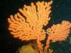 Sinuous sea fan
 Sponge
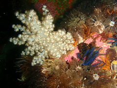 Cauliflower soft coral
 Sponge crab on sinuous sea fan
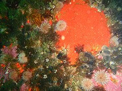 Mauve sea cucumbers
 Hydroids
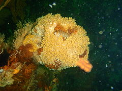 Bryozoans
 Orange sponge
 Sea cucumbers
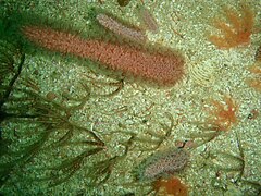 Purple sea pen


Photography
[edit]This is a good photographic site. Unless the visibility is particularly good, macro equipment will usually give the best results.
Stay safe
[edit]Hazards
[edit]A Great White shark was once seen by a group of scuba divers at the northern pinnacle.
Skills
[edit]No special skills required, but much of the reef is below the depths recommended for entry level divers. The ability to deploy a DSMB is useful as dives are from a live boat.
Equipment
[edit]A light is useful to restore colour at depth, a compass to keep track of your movements, a DSMB to let the boat know where you are surfacing, and nitrox can extend no-decompression time significantly in this depth range.
Nearby
[edit]
- 1 Livingstone Reef
- 2 Castor Rock - Central Pinnacle
- 3 Friskies Pinnacle
- 4 Roman Rock
- 5 Tivoli Pinnacles
- 6 Dome Rock
Back to the Alphabetical list of sites, or list of dive sites in the Roman Rock area
Other regional dive sites:
- Dive sites of Table Bay and approaches,
- Dive sites of the Cape Peninsula west coast
- Dive sites of False Bay offshore and approaches
- Dive sites of False Bay east coast
- Fresh water dive sites of the Cape Town Metropolitan Area