The dive site Roman Rock is an offshore rocky reef in the Simon's Bay area on the False Bay side of the Cape Peninsula, near Cape Town in the Western Cape province of South Africa. This site includes the small outliers Spider Crab Reef to the south-west of Roman Rock, Roman Rock North and Roman Rock South.
This site comprises a cluster of huge outcrops separated by sand bottom, on one of which the lighthouse stands.
Understand
[edit]
Roman Rock reef is part of the Roman Rock reef complex offshore in Simon's Bay on the west side of False Bay. This is an extensive area of granite reef, much of which is inside the Boulders restricted zone of the Table Mountain Marine Protected Area. It is a topographically rugged reef, with exposed rocks and a few other very shallow areas, and extends down to a sand surround. The reef complex has several large reef areas, of which this is the south-westernmost, and a large number of smaller reef sections and isolated rock outcrops. The marine life is quite varied, though echinoderms are dominant, and a moderate variety of reef fish can be seen.
The site is popular when launches are made from the False Bay Yacht Club, as it is conveniently close. The reef is prominently marked by the exposed rocks and the lighthouse — You can't miss it...
Position
[edit]1 Roman Rock: S34°10.87’ E018°27.60’ — Maximum depth 21 m. An easy dive site to find as it is marked by the lighthouse of the same name off Simon’s Town Harbour. A large granite reef with a depth range from 20 m at the east end to the surface around the lighthouse rocks.
This site is entirely inside the Boulders Restricted Zone of the Table Mountain National Park Marine Protected Area, proclaimed in 2004. A permit is required.
Name
[edit]
There are several places on the South African coast known as "Roman Rock", and Roman Reef, and it is probable that they are all named after the common endemic reef fish, the Roman, Chrysoblephus laticeps. Spider crab reef was given the name because several spider crabs were seen on the first recorded dive at the site.
Depth
[edit]Maximum depth is on sand at about 21 m to the south and east. The top of the reef breaks the surface in places. The eastern part of the reef has a greater depth range than the western part.
Visibility
[edit]Visibility is variable, and is unlikely to differ greatly from other nearby sites. 10 m would be considered good, 15 m excellent, and 4 to 6 m marginal. The offshore reefs are less affected by south easterly winds than those closer inshore, as the sand bottom is too deep to be affected by wind chop, and the limiting factor in a south easterly wind is often surface conditions rather than visibility.
Topography
[edit]All of these reefs are granite ridges, mostly following a roughly northwest-southeast trend of jointing fractures. Roman Rock is by far the largest in length, width and height, and is also the most varied in profile. They are all surrounded by fairly flat sand bottom, which varies by a few metres in depth over the length of the reef, but this is locally imperceptible ans appears flat.
Geology: Granite corestone outcrops and boulders of the late Pre-Cambrian Peninsula pluton, surrounded by whitish quartz sand, with a varied amount of shelly debris, gravel and biogenic detritus.
Conditions
[edit]This site can be dived any time of the year that has low or short period swell. It is a bit further around the corner from the prevailing south-westerly swell. Poor visibility at the surface does not necessarily extend to the bottom. It is a short boat ride from the Simon's Town Jetty, so is often a fall-back option when conditions further towards Cape Point are unpleasant. The site is exposed to winds from all directions, which can produce an unpleasant choppy sea, and make it difficult for the boat crew to see a diver on the surface. The site is usually at it's best in winter and spring.
Get in
[edit]This site is always dived from a boat, though Navy divers in training were traditionally required to swim back to the base from this area, The site is 3.3 km from Simon's Town jetty or the yacht club, and 5.6 km from Miller's Point slipway.
Do
[edit]Dive at one of the listed drop points, and explore the reef in the vicinity.
1 Roman Rock North: S34°10.813’ E018°27.535’ — A fairly large but relatively low expanse of reef roughly northwest of the lighthouse, of no known special interest. Shallowest point at about 11 m, and maximum depth about 18 m on the sand to the north-west. Much of the perimeter and contours has been surveyed and mapped, but not all. The reef is about 120 m west to east, and about 80 m north to south. The ridge line axis is northwest to southeast, and there is a lower lobe extending to the northeast. The top of the reef is at about 11 m depth, and the sand bottom varies from about 15 to about 18 m. There is a large part which is massive outcrop and large boulders, and the perimeter has areas of smaller scattered boulders and minor outliers. The adjacent bottom in some areas is shelly gravel and biogenic detritus. Biodiversity appears to be lower than at the main reef, possibly due to less varied topography. A length of small diameter pipe about 50 m long lies across the low part of the eastern lobe and extends onto the sand to the north. It is broken and has no obvious purpose. Several nesting sites of the Steentjie have been seen around the edges of the reef.
2 Roman Rock: S34°10.87’ E018°27.60’ — Maximum depth 21 m. An easy dive site to find as it is marked by the lighthouse of the same name off Simon’s Town Harbour. A large granite reef with a depth range from 20 m at the east end to the surface around the lighthouse rocks. Flat coarse shelly sand bottom at 15 to 18 m with large granite corestones. Very large boulders and outcrops extend over a fairly large area, with deep gullies and high ridges. Dramatic relief. Two large rocks break the surface and support the lighthouse structure and a small helipad. The long axis of the reef runs roughly southeast-northwest and the main reef is about 400 m long and 110 m wide north to south, with the widest point to the east of the lighthouse. The Eastern part of the reef is very high profile, and extends from the sand to shallower than 3 m in several places, though the extreme southeast part slopes more gradually. The western section is demarcated by a deep gully opening to the south, with sand bottom extending some way across the reef, which nearly disconnects the shallower western section from the eastern section. Minimum depth of the western section is about 10 m, and much of it is deeper than 12 m. There is a smaller ridge of reef approximately parallel to the main reef about 20 m away to the north east of the north west end of the main reef, and a few unsurveyed patches nearby.
3 Spider Crab Reef: S34°10.90' E018°27.435' — Two small parallel reefs to the west of Roman Rock, rising from sand at about 21 m to 16 m at the shallowest point. They are separated by a narrow sand gap and can be seen from each other in reasonable visibility. Some distance to the south west of the main reef there is a small patch of reef called Spider Crab Reef, so named as a relatively large number of spider crabs were seen by several divers on the day the reef was first surveyed. The top of the northern section of this reef is flattish at about 16 m depth with some moderate jointing crack gullies, and it extends about 100 m from north west to south east and is about 20 m wide. The eastern and western ends of this reef consist of relatively small and low outcrops, with narrow sandy gaps between them. The southern section of Spider Crab Reef is a short distance away across a narrow sandy gully and is shorter, narrower, lower and more broken up than the main section.
4 Roman Rock South: S34°10.930’ E018°27.575’ — There is a smaller section of reef to the south across a small belt of sand roughly parallel to Roman Rock main reef. It is far enough away to not normally be visible. It has been partially surveyed and mapped. The eastern part of this reef is steep sided and flat topped, with a minimum depth of about 15 m, and maximum of nearly 21 m on the sand on the south side. This area has a few sea fans and other variations on the echinoderm theme, but the cover in May 2019 was mainly sea cucumbers and brittlestars. To the west it slopes down, then breaks up into an extensive region of low outcrops and medium to fairly large boulders, some of them probably over 3 m high, with some steep sides and crevices on which a wider variety of reef organisms live. The reef is about 140 m long northwest to southeast, and maximum width is about 40 m. The bottom around this reef has large areas of coarse shelly gravel.
Routes
[edit]There are no recommended routes. Start deep and work your way along the base of the rocks, slowly ascending and preferably surfacing from the top of a high outcrop if there is not too much surge.
See
[edit]Marine life
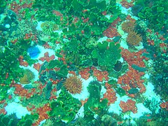
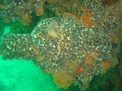
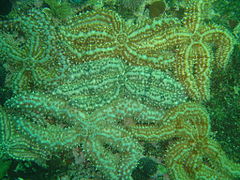
[edit]The rocks are encrusted with a variety of organisms depending on depth and orientation. The intertidal and shallow subtidal zone of the main reef can be heavily encrusted by black mussels, There is kelp and sea urchins on the tops in shallower areas, and red-bait and other large solitary ascidians scattered around. The steeper sides are largely covered by common feather stars, with some dense areas of mauve sea cucumbers on the tops of ridges, There are also occasional sea fans, some quite large. The sand is coarse and shelly near the rocks, and there are sand stars, brittle stars, sand slugs, cerianthids and purple sea pens on the sand. Dense aggregations of the spiny starfish can sometimes be found, often where there are large numbers of mussels.
The top of Spider Crab Reef is covered by large black mussels and quite a lot of spiny starfish. The deeper parts and sides are more typical of the area, with patches of mauve sea cucumbers, common feather stars, strawberry anemones and encrusting sponges. There were large numbers of hairy brittlestars on the reef and serpent skinned brittlestars on the sand. There are also a moderate number of sea fans and striped sea anemones. On one occasion quite a number of spider crabs were seen, but as they are well camouflaged it is hard to tell if they are still there.
Roman Rock South has a dense covering of fragile brittlestars on the reeftop and large numbers of serpent skinned brittlestars on the surrounding sand. There are sea fans anemones and colonial ascidians along the steeper sides, and small shoals of reef fish, mainly hottentot.
- Anemones
- Blue spotted klipfish
- Crowned nudibranch
- Reef top life
- Sandy anemones
- Striped anemones on a large Red-bait pod
- Spiny starfish
Photography
[edit]This is a good photographic site. Macro or wide angle lenses are suggested.
Stay safe
[edit]Hazards
[edit]Great white sharks have been seen in the vicinity. In windy weather a diver on the surface may be difficult to see from the boat due to choppy waves.
Skills
[edit]No special skills required, though the ability to deploy a DSMB is useful in case you are separated from the group or need to surface away from the shot line.
Equipment
[edit]A light is useful to restore colour at depth, a compass to keep track of your movements, a DSMB to let the boat know you are surfacing, and Nitrox can extend no-decompression time significantly in this depth range.
Nearby
[edit]- 1 Livingstone Reef
- 2 Target Reef
- 3 Castor Rock - Central Pinnacle
- 4 Friskies Pinnacle
- 5 Tivoli Pinnacles
- 6 Rambler Rock Southern pinnacles
- 7 Dome Rock
Back to the Alphabetical list of sites, or list of dive sites in the Roman Rock area
Other regional dive sites:
- Dive sites of Table Bay and approaches,
- Dive sites of the Cape Peninsula west coast
- Dive sites of False Bay offshore and approaches
- Dive sites of False Bay east coast
- Fresh water dive sites of the Cape Town Metropolitan Area


