The dive site South Lion's Paw or just South Paw is in the Clifton area on the Atlantic seaboard of the Cape Peninsula, part of Cape Town in the Western Cape province of South Africa.
Understand
[edit]
Position
[edit]- 1 South Lion's Paw: S33°56.308’ E018°21.890’
South Paw is about 600 m offshore of the headland between Clifton and Camp's Bay.
This site is in the Table Mountain National Park Marine Protected Area since 2004. A permit is required.
Name
[edit]The name "South Lion's Paw" is an allusion to the mountain "Lion's Head" directly above Clifton. The mountain is likened to the head of a reclining lion, whose back is Signal Hill, and whose paws are the two groups of rocks to the south and north of Clifton.
Depth
[edit]Maximum depth recorded is about 20 m
Topography
[edit]Granite corestone outcrops and boulders of large size, a small group of which break the surface and have precipitous walls dropping almost vertically to about 15m. They are surrounded by other smaller boulders and lower outcrops which extend some distance in all directions. There are small patches of coarse shelly aggregate in the bottom of the gullies, but no extensive sand bottom nearby. To the north of the eastern end of the exposed rocks is a large boulder with an arch against the main rocks, and there is a deep narrow gully along the north side, but the surge may be strong in this area. As is usual with this type of reef formation there are holes and overhangs under some of the boulders.
Geology: Granite of the late Pre-Cambrian Peninsula pluton
Conditions
[edit]The site is exposed to the south west swell, so should be dived in low swell, and is often good after south east wind. The site is reasonably protected from south east winds, but if they are strong the boat trip may be unpleasant.
The site is usually at it's best in summer but there are also occasional opportunities in autumn and early winter.
This is an area which sometimes has upwellings, caused by the south east wind, resulting in cold clear water, which may develop an algal bloom over a few days which will reduce the visibility again
Get in
[edit]This is a boat dive. The site is 7.7 km from Oceana Power Boat Club slipway, Granger Bay, or Cape Town Harbour V&A Waterfront. Best done as a live-boat dive due to the proximity of the exposed rocks and the strong surge over the top of the shallower rocks.
See
[edit]Marine life
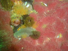
[edit]Marine life is typical of the general area. There is not much sea bamboo kelp as the reef is mostly too deep for it. The shallower rock surfaces have the usual heavy encrustation of red bait, and deeper steep and overhanging surfaces are covered by sponges, colonial ascidians, sea fans and anemones. Less steep deep surfaces have urchins and grey sea cucumbers. The nippled nudibranch has been photographed here, and is not known from anywhere else. If you see or photograph one, please notify SURG.
- The nippled nudibranch is probably an undescribed species known only from South Paw
- Dreadlocks hydroids
- Sponge and sea cucumbers
Photography
[edit]This is a good site for macro invertebrate photography.
Routes
[edit]No route is particularly recommended, but it may be advisable to keep clear of the exposed rocks at shallow depth to avoid being washed onto them by the surge. This will depend on conditions on the day.
Stay safe
[edit]Hazards
[edit]Cold water, strong surge and breaking waves over exposed rocks. Sea urchins. Strong offshore winds may develop over a short time.
Skills
[edit]No special skills required, but the ability to deploy a DSMB would be useful. Not a site for the novice if there is much swell running.
Equipment
[edit]A DSMB is suggested for unencumbered manoeuvering during the dive, while allowing the boat crew to monitor your position during ascent. It is not recommended to ascend close to the surface piercing rocks as the surge can be strong and it may not be possible to control your depth and ascent rate. A light will be useful to look into crevices and restore colour at depth. Nitrox may be of value depending on your planned dive. A compass will be useful to help keep track of where you are.
Nearby
[edit]- 1 Sea Point Ridge Pinnacles
- 2 Bantry Bay
- 3 North Lion’s Paw Main Reef
- 4 Clifton Rocks
- 5 Cleeve's Tunnel
- 6 Bakoven Rock
Back to the Alphabetical list of sites, or list of dive sites in the Clifton area
Other regional dive sites:
- Dive sites of the Cape Peninsula west coast
- Dive sites of the Cape Peninsula east coast
- Dive sites of False Bay offshore and approaches
- Dive sites of False Bay east coast
- Fresh water dive sites of the Cape Town Metropolitan Area


