| E69 has been nominated for featuring on the main page as Featured Travel Topic. We may have failed to notice some minor glitches in the article. Please plunge forward and help improve it further before it hits the main page. |
The northernmost European route, E69, is not a particularly long one, linking E6 to the northernmost point of Europe accessible by road, Nordkapp. It's the northernmost highway in the world connecting to an international road network, reaching up to 71° north (the few highways in Svalbard, Greenland and Nunavut are not connected to the rest of their respective highway networks).
This article describes the route from south to north, as its north end is a cul-de-sac.
Understand
[edit]
E69 is a picturesque highway in the Finnmark region of Norway, with an immense amount of eye-catching scenery and a wealth of cultural significance – it is easily one of the most scenic highways on the European route (E-route) network. The highway is 129 km long and includes five tunnels with a total length of 15.5 km (about 12 per cent of the journey). The longest tunnel is the North Cape Tunnel (Nordkapptunnelen) with a length of 6.9 km.
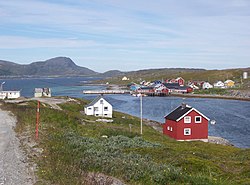
It starts in Olderfjord and meanders towards the north – along the way, you will see stunning fjords, mountains, waterfalls and diverse wildlife. This is in addition to somewhat noteworthy towns such as Hammerfest, which offer valuable glimpses into Sami culture.
The northernmost part of the road between Skarsvåg and the Nordkapp is limited access road via a convoy in winter.
Prepare
[edit]Due to the unpredictable weather, it is advisable to check the conditions prior to embarking on your journey. Keep in mind that fuel stations and accommodations may be scarce in remote areas.
While all tunnels can be cycled through, try to increase visibility by wearing reflective clothing, such as a reflective vest, especially during bad weather and rapidly changing visibility outside the tunnel.
The weather is cold and ranges in the single-digits during summer – see cold weather and if you're driving during winter, winter driving, for handling the weather. Also see driving in Norway for other tips for driving in this region of Norway.
Get in
[edit]The start of the 127-kilometre drive is at the small village of Olderfjord and is a turnoff from E6. To get to Olderfjord itself, you will need to drive 108 km (67 mi) north-east of nearby Alta or 137 km (85 mi) north of Karasjok (a town just 19 km west of the Finnish border).
There is an airport at Honningsvåg near the northern end of E69, but you'll need a car (or bike) to drive this route.
Drive
[edit]Olderfjord–Repvåg
[edit]The drive starts at 1 Olderfjord (Northern Sami: Leaibevuotna; Kven: Leipovuono) – it's the last village with decent accommodation and fuel before the good chunk of drive further, so make sure to fill up before starting. The one fuel station, 1 Best Olderfjord, is not particularly large; in extreme rare cases, it may be limited in supplies. Prepare for the worst before you arrive here.
The first 5 km of the road winds its way up the hills with forests so green (during summer) that you'd be forgiven for thinking you haven't yet passed the Arctic circle. You'll then arrive at 2 Smørfjord, home to a Sami settlement with many cultural artefacts since the Neolithic Age. Head 3.5 km (2.2 mi) north of the T-intersection with Rte 889 is 1 Sjøsamisk Tun, a reconstructed Sami settlement and a great place to learn more about Sami culture.

From Sjøsamisk Tun, the road is mostly flat and follows the coast for about 11 km until 3 Nordmannset, which is nothing more than a tiny hamlet. This section of the road gives an impressive mix of views – on your left (and to the north-west), you'll see lush hills, and on your right, you will have views of the fjord – put both of these together and the output is a picturesque landscape.
Before March 2023, the route would have continued on an older narrower tunnel, but the completion of the newer 3.56-km 2 Skarvbergtunnelen (sometimes Skarvberg Tunnel; Northern Sami: Sieidditunealla; Kven: Skaarpärkintunneli) has meant that you do not need to drive in a worn-down 1968 tunnel that added 1.5 km to the journey (the old tunnel still exists abandoned, if you were wondering).
The next 21 km (13 mi) is a lovely charming fjordside drive – 5 km into the drive and you'll come across the 496-metre 3 Sortviktunnelen – travel 3 km further and you'll arrive at Sortvik Rastplats, a rest stop and an information bay.
Repvåg
[edit]
You will then see the turnoff to Fylkesvei 8054 (Fv8054; county road 8054) to 4 Repvåg (Northern Sami: Reiffváhki), a fishing village of 14 but with amenities, which include:
- 1 North Cape King Crab A/S, Repvåg 47, ☏ +47 45 87 53 30, post@northcapekingcrab.no. A wholesaler of red crab based in Repvåg – it's also the only independent eatery in Repvåg (that is, an eatery outside the hotels).
- 1 Hotel Repvåg, Repvågveien 318 (Fv175), ☏ +47 91 87 14 73. Check-in: 15:00, check-out: 12:00. Mid-range hotel with food, drink and parking included. There is also a free shuttle from Honningsvåg Airport.
- 2 Repvåg Overnatting Nordkapp, Repvåg 5, ☏ +47 45 85 20 69, repvaag@online.no. 15 May–30 September. Has cabins in addition to campsites (and pitches for motorhomes and caravans). Also has an on-site kiosk.
Keep in mind that Repvåg is only a side detour; you do not need to stop at Repvåg if you don't have the need to sleep along the way or don't require a break.
Repvåg–Honningsvåg
[edit]
Once you've passed Repvåg, you're more than a third of the way there. The next stretch of road north from here does get very desolate, though: there are almost no side-roads, and the few that do exist are side roads towards individual properties.
In the midst of desolateness about 19 km north of Repvåg, there is a short hiking trail branching out to 2 Porsangnes batteri. Head for another 10 km and you'll reach the southern portal of 4 Nordkapptunnelen, a 6.9-km subsea tunnel reaching depts of 212 metres below sea level.
You've now left the mainland – just outside the tunnel on your left is 5 Veidnessletta. It's a rest station, but it's also a good place to stop and take some photos of the serene landscape (try to minimise your trail of destruction by keeping to the road, but that may not always be possible). Just to the north of the rest area is 3 Veidnesbrua, a 520-metre steel-box bridge. There's even a narrow footpath that links it up with the rest area, if you do want to walk on the bridge. After the bridge, you'll immediately be back under the depths of the mountains of Norge as you head underneath 6 Sarnestunnelen, which is way shorter at only 195 m long. 4 km out of the tunnel, slowly making your way around the bay, and you'll arrive at the small village of 5 Sarnes – much of it is now abandoned, including an old boarding school and a post office. However, Sarnes does contain the following amenities:
- 2 Sarnes pop-up restaurant, Sarnesveien 14, ☏ +47 472 89 320, Mail@71-nord.no. W–Su 13:00–20:00. A restaurant opened up by Destinasjon 71 based in Honningsvåg with good views of the fjord.
Sarnes is the final town before you enter 7 Honningsvågtunnelen – it's the final tunnel along this route and is the northernmost road tunnel in Europe (and possibly even the world). After 4,440 metres of being in the void, you will have finally arrived at the northern fringes of 6 Honningsvåg.
Honningsvåg–Skarsvåg
[edit]
This section of the road further north becomes narrower and windier (with no tunnels), and the median may not always be marked. The road quality is also much worse here; drive with extra care.
For the first 10 km, there's nothing extraordinarily interesting – 6.5 km in and you'll pass 3 Nordkapp Camping, 7 km (500 m from Nordkapp Camping) and you'll find the turnoff to Kamøyvær, but 10 km and you'll encounter 4 Skarsvågrevva on your left – its position means that it might just be better if you visit this lookout on your way back; you will still be treated to beautiful mountain views looking down from just 300 m in elevation.
After a bit of driving, you will then arrive at the 8 Fv126 turnoff to Gjesvær (which is 21 km from E69), which is home to a fuglefjell (basically a seabird mountain) and is one of Norway's largest fuglefjells. In addition, it's the only Finnmark town known from the Viking era, as it was used en route towards the journey to Bjarmaland. If you have spare time, it's worth checking out this rather off-the-beaten-path destination.
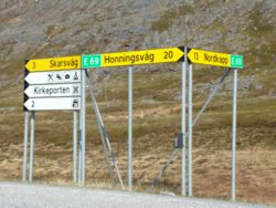
The road from here widens up – enjoy the drive o'er vales and hills. 9 Utsiken–Turfjordhøyda is a rest stop that should appear on your left, although it is more of a lookout (the north of the lookout gives a good view of a fjord). Otherwise, keep driving north-east until you reach 7 Skarsvåg, the final settlement before you reach Nordkapp.
Skarsvåg–Nordkapp
[edit]
This final 12 km of E69 is narrow – most of the road is barely wide enough for two vehicles to pass each other. In addition, this section of road is only open during the summer. During winter, you will have to travel this last stretch via a convoy – refer to Nordkapp § Get in for the specifics.
If you're driving in summer, there aren't any major points of interests here – relish the drive and the views of the treeless plain for the last few kilometres. Before you know it, you will have reached the car park at 5 Nordkapp, officially the northernmost point of Europe proper accessible by road.
Stay safe
[edit]Many of the concerns listed on E6 through Sweden and Norway § Stay safe also apply to E69. In particular, this part of Norway has some of the coldest climates in the Northern Hemisphere. Reindeer can also cross the road at times.
Go next
[edit]Head back on the road on E6 through northern Norway. E75 and E8 are the next closest E-routes.
If you have had enough of driving, the Hurtigruten ferry service calls at Honningsvåg daily in both directions, and you can take your car on board too.


