
Fichtelgebirge

Fichtelgebirge (Fichtel Mountains) is arranged like a horseshoe around an inner hill-landscape in Upper Franconia
Regions
[edit]
The highest mountains are in the west, while the mountains in the east take on a horseshoe shape. In the middle of this "horseshoe" there is a plateau, which is in no way inferior to the high Fichtelgebirge. This results in two regions and one, for political-historical as well as size-related (in relation to the number of inhabitants) reasons, city region:
- Hohes Fichtelgebirge - the western part with the two thousand meter high mountains; almost completely covered with forest.
- Sechsämterland - (six administrative districts land) is a term from the time of the Bayreuth margraviate, but it is still often used today. The area includes the high plateau and the somewhat lower mountain ridges in the north and south compared to the high Fichtelgebirge.
In the southeast, the communities of Brand, Ebnath, Immenreuth and Neusorg are already in the district of Tirschenreuth, in the administrative district of Upper Palatinate. Some northeastern foothills reach as far as West Bohemia in the Czech Republic.
Cities
[edit]- 1 Arzberg - in the valley of the Röslau and dominated by the Kirchberg with the protestant church; nearby the local recreation area Feisnitz-Stausee.
- 2 Bindlach - at the base of the Fichtelgebirge near Bayreuth.
- 3 Bad Berneck - Kneipp resort since 1930, spa gardens with colonnades.
- 4 Bischofsgrün - holiday resort between Ochsenkopf and Schneeberg; not far from a summer toboggan run.
- 5 Gefrees - on the southern edge of the Münchberg plateau and a small town on the border of the Fichtelgebirge nature park; folk and meadow festival in July.
- 6 Goldkronach - small town on the western edge; former gold and silver mining.
- 7 Kirchenpingarten - at the southern base of the Fichtelgebirge.
- 8 Marktredwitz - in the southeast of the Fichtelgebirge; economic centre of the Wunsiedel district. The Egerland Museum has exhibits on the old homeland before 1945.
- 9 Selb - the city of porcelain and after Marktredwitz second largest city in the Fichtelgebirge nature park.
- 10 Speichersdorf - the railwaymen village at the southern base of the Fichtelgebirge.
- 11 Weidenberg - Glass and button museum, tin figure museum and cemetery church.
- 12 Weißenstadt - is on the shore of the 48-hectare large Weissenstadt Lake (Weißenstädter See) and on the upper course of the Eger river, which rises southwest of the town.
- 13 Wunsiedel - county town of the district of the same name; two outstanding sights in the immediate vicinity of the town: the Fichtelgebirgsmuseum and the Luisenburg rock labyrinth.
- 14 Zell im Fichtelgebirge - at the spring of the Saale.
Other destinations
[edit]Mountain peaks
[edit]- The 1 Schneeberg
 (1.053 m above sea level) is the highest mountain of the Fichtelgebirge. The wooden observation tower is called Backöfele. The road to the summit is closed for vehicles. The former military listening tower cannot be entered.
- The 2 Ochsenkopf (ox head) (1024 m above sea level) NN) with observation tower, chairlift, summer toboggan run (1000 m long with 140 m difference in altitude) and ski slopes
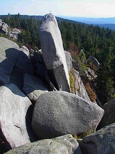
- The 4 Plate is an 885-m-high mountain in the southern Schneeberg massif. The summit is surrounded by a massive block heap of angular granite slabs.
- The 5 Hohe Matze is an 813-m-high mountain on the 50th latitude and on the watershed between North Sea and Black Sea. On the rock formation at the summit is a summit cross.
 Nußhart
 Transmitting tower on Ochsenkopf
 Backöfele on the top of Schneeberg


Understand
[edit]Get in
[edit]By car
[edit]The Fichtelgebirge is located between the Autobahn 9 Nuremberg - Leipzig and the Autobahn 93 Hof - Regensburg. Furthermore the federal road B 303 crosses the area from Bad Berneck via Marktredwitz to Eger. (Cheb).
Parking
[edit]There are parking meters at cross-country ski run and hiking parking lots around the Ochsenkopf. For €2 (2019) you can park for 24 hours, also on various paid parking lots. Furthermore, for €20 you can buy a season ticket and for €30 an annual ticket, you can buy them directly at the cable cars at the Ochsenkopf ☏ +49 9276 644. The parking fees are used for clearing and gritting services, and preparation of the cross-country ski runs and winter hiking trails. Complaints and questions to fairparken GmbH, ☏ +49 211 96082630 or e-mail: info@fairparken.com
By train
[edit]You can reach the Fichtelgebirge by train via stations in Hof or Marktredwitz.
- The EgroNet ticket. An inexpensive train ticket, It is valid in the districts Greiz and Saale-Orla in Thuringia, in Hof, Kulmbach, Bayreuth, Neustadt an der Waldnaab, Weiden, Tirschenreuth and Wunsiedel in Upper Franconia, in Saxony in Vogtland, Zwickau and the Western Ore Mountains and in Czech Republic in the Karlovy Vary region. The day ticket for the second class costs €22 (200 Kč in the Czech Republic) (plus €2 in Germany, if you buy at the counter) for the 1st person. For the 2nd to 5th person the additional charge is €7 (100 Kč) each. You can make as many trips as you like on the day of validity until 03:00 of the following day with the participating transport companies. Additionally it is allowed to take 3 children between 6 and 14 years and as many as you like under 6 years. One bicycle per person is also free of charge. The surnames and first names of all passengers are to be entered in block letters on the ticket, ID cards must be kept ready.

By plane
[edit]The nearest airport with regular commercial service is in Nuremberg (NUE IATA). Many international flights arrive in Germany via Frankfurt airport (FRA IATA) or Munich airport (MUC IATA), however.
Get around
[edit]See
[edit]

- 1 Luisenburg Rock Labyrinth (Luisenburg-Felsenlabyrinth). 08:30-18:00. Adults €4.50.

- The 4 sources of Saale, White Main, Eger and Fichtelnaab.
Do
[edit]Winter sports
[edit]Winter hiking trails[dead link] are marked with yellow signs. Some of them run right next to the cross-country ski runs, neither the groomed nor the rolled cross-country ski runs are accessible, everyone has his own area! Do not leave the signposted hiking trails. Frightened wild animals are forced to use up unnecessary energy when fleeing, which can mean death for animals at this time of year.
Alpine skiing
[edit]Ski area at the Ochsenkopf with two chair lifts. There are two easy slopes with a total length of about 3.5 km. The longest slope is 2300 m long. Snow cannons are available. More info is available online.
Ski lifts:
- Oberwarmensteinach, the Hempelsberg and Geiersberg ski area offers two T-bar lifts, Geiersberglift length 450 m, Hempelsberglift length 600 m
- Königsheidelift Warmensteinach, more info: ☏ +49 9277 15 21
- Klausenlifte in Mehlmeisel - 700 m long snow-making slope, which is between 650 and 815 m high.
- Ski lift Neubau
- Bleaml Alm in Neunau
- Kornberg with two pistes of 700 m length each, as well as a practice piste of 130 m length for the piste report is available on the Internet or under ☏ +49 9287 2225
- Klingelbrunnenlift near Arzberg, T-bar lift with floodlights, slope length 200 m, slope width 100 m, height difference 50 m, snow telephone ☏ +49 9233 9700.
Nordic skiing
[edit]There are many circular and connecting trails, for more details see Nordic-parc.de[dead link].
- Night cross-country trails: Bleaml Alm (Neubau/ Fichtelberg), Wagenthal (Warmensteinach) and trail Kornbachtal (Kornbach/ Gefrees) are illuminated until 21:00.
- Snowshoe hikes are offered by Klaus Hübsch, Schlossstraße 8, 95448 Bayreuth, ☏ +49 921 9900687 or ☏ +49 160 99834768. Hikes of different lengths are offered, snowshoes are provided.
Summer sports
[edit]- Dévalkart driving, karts down the downhill run. In Oberwarmensteinach at the Geiersberglift.
- Downhill - Mountainbiking, Downhill route with wooden crossings and Northshoresprung at the Ochsenkopf. With the cable car the bikes can be taken up to the top (www.fichtlride.de, www.lettenbrueder.com).
- Bike rental and test bikes at Bullhead House, Fleckl 13, 95485 Warmensteinach, ☏ +49 9277-975379
- Luisenburg with nature stage, open-air festival, and the rock labyrinth.
Hiking
[edit]- The Höhen- und Steinwaldweg leads on 77 km over the most important mountain peaks of the Fichtelgebirge, through the Stiftland and the Steinwald. The hiking trail begins in Schwarzenbach an der Saale and ends in Waldsassen. Further information is available online.
- The Seenweg (lake trail) runs for 150 km from Steinbach am Wald in the Frankenwald to Speichersdorf at the base of the Fichtelgebirge.
Eat
[edit]The inns are becoming fewer, especially in the small villages. Also the opening hours are reduced, there are more rest days. If you are planning a stopover, especially when hiking, you should call in advance to see if they are open and if there is room. Especially on Sunday noon it is recommended to reserve a table in time.
Around 1647, farmers in nearby Pilgramsreuth, a district of Rehau, started to grow potatoes. This is the earliest known cultivation of potatoes in Germany, which are also called Erdäpfel in dialect. Still today the potato is eaten in many variations and grows especially well on the barren soil.
A new trend in the Fichtelgebirge is the 'wild herb cuisine, a group of cooks[dead link] has made it their business to integrate the local wild herbs into their dishes and thus create new taste experiences.
The Skirt steak is called Kronfleisch in the kitchen. The coarse-grained, dry muscle meat, mostly from beef, is often eaten in the Fichtelgebirge with bread, herb butter and horseradish. Innkeepers in the villages Arzberg, Thierstein, Thiersheim, Hohenberg, Höchstädt and Schirnding have joined forces and offer regular meals of Kronfleisch.
The 'Fichtelgebirgs-Pumpernickel are longish shaped gingerbread with sugar coating. They are widespread in and around Marktredwitz since well before 1800.
Sechsämterschinken is marinated for about 6 weeks in a mixture of spices, Sechsämterkräuter and Sechsämtertropfen and then smoked for 1 week with beech wood. He is smoked by the 1 Metzgerei Reichel Reichel butchery in Bad Alexandersbad.
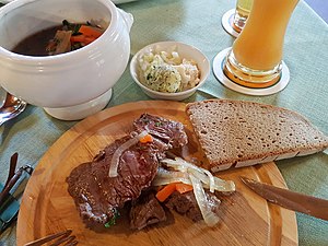 Kronfleisch in root stock. Served with garlic butter, grated horseradish and chopped onions and served with bread. The crown meat can be ordered medium or pulled through. The root stock is spooned at the end.
 Pumpernickel gingerbread


Drink
[edit]The well-known Sechsämtertropfen (herbal liqueur) originates from the Sechsämterland in the middle of the Fichtelgebirge. The liqueur is produced in Wunsiedel.
Buy
[edit]- 2 Rosenthal Outlet Center, Philip-Rosenthal-Platz 1, 95100 Selb. M-Sa 10:00-18:00. The world-.famous porcelain manufacturer Rosenthal operates an outlet center at their home base in Selb.
Stay safe
[edit]In regularly published statistics of the police, Upper Franconia is presented as the administrative district in Bavaria with the fewest crimes per inhabitant. On the national average, Bavaria is one of the leaders in terms of security.
Parts of the Fichtelgebirge are located near the border to the Czech Republic, where, after the abolition of border controls, searches are carried out in the area behind the border.
In the mountains themselves, the Bergwacht ensures safety for hikers and skiers. BRK Mountain Rescue, ☏ +49 9276 352, Mountain Rescue Section Fichtelgebirge, ☏ +49 9276 91090.