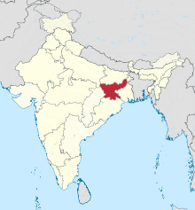
Jharkhand[dead link] is a state in Eastern India. Home to the Chota Nagpur Plateau, Jharkhand can fairly claim to be one of the most attractive parts of the Indian peninsula. The scenery of the main plateau is most attractive with its undulations, detached abrupt hills and forest tracts. To complete the attraction of the Jharkhand, the locals are a lovable and cheerful people.
Cities
[edit]Here are some of the most notable cities.
- 2 Bokaro Steel City — one of the most important industrial cities in Eastern India
- 3 Daltonganj —
- 8 Hazaribag — home to Hazaribagh Lake and Hazaribagh National Park
- 9 Jamshedpur — famous for its park and cricket stadium, an industrial city
- 12 Massanjore — site of the Massanjore Dam
Other destinations
[edit]- 1 Betla National Park — one of India's first national parks formed primarily for the protection of tigers
- 2 Hazaribagh National Park — sambhar, nilgai, chital and kakar can be seen at dusk and dawn at water holes
- 3 Panchet Dam — a popular picnic spot
Understand
[edit]Most of Jharkhand is spread out on the Chota Nagpur Plateau. The name Nagpur is probably taken from the Nagbanshis who ruled in the area. Chota is a corruption of Chutia, a small village near Ranchi where the Nagbanshis had a fort. The plateau consists of three steps. The highest is in the west of the province rising to around 3,000-3,500 feet above sea level. The next level spread around Ranchi and Hazaribagh in the central sector is around 2,000 feet. The eastern part is the lowest at around 1,000 feet. A part of the plateau slopes into neighbouring West Bengal.
The indigenous people are Sadan (a local Indo-Aryan ethno-linguistic group) and Adivasis (tribals). The Sadan speak three local languages, Khortha in the North Chotanagpur subdivision, Sadri (Nagpuri) in the south Chotanagpur subdivision and Kurmali (Panch Pargania) in south-east Jharkhand. The Sadan consist of various castes and tribes. The Adivasis (tribals) are divided into three main anthropological divisions, the larger consisting of the Austro-Asiatic ethnolinguistic groups of the Mundas, Santhals, Hos and some smaller tribes; the second group are Dravidian Oraon or Kurukh tribes.
Coal is found in several fields across Jharkhand - Jharia, Bokaro, North Karanpura, South Karanpura, Ramgarh, Giridih, and Santhal Parganas. Large quantities of iron ore are found in Singhbhum. Fire-clay, mica and other minerals are also mined.
Talk
[edit]Hindi is widely understood throughout the state. The Khortha language spoken in North Chotanagpur subdivision, Sadri (Nagpuri) in South Chotanagpur subdivision and Kurmali (Panch Pargania) in south-east Jharkhand. Oriya is also widely understood and spoken in Saraikela, and Bengali is spoken in the eastern parts of the state. Different tribal languages are spoken in different areas. English is understood in the main cities.
Get in
[edit]Most of the road links into the state are from the north and the east. The western part is more mountainous and hence road links are less. Now links with the south and the west are also being developed. The Grand Trunk Road (NH 2 Kolkata Delhi) cuts across the northern part of the state. NH 6 connecting Kolkata with western India enters the south-east corner of the state for a short span.Ranchi, Bokaro, Jamshedpur and Dhanbad are well connected through neighbouring State and major cities.
The Howrah-Delhi main and Grand Chord lines cut across the northern part of the state. The Howrah-Mumbai lines goes via Jamshedpur in the southern part of state. The Barkakhana-Sonenagar and other links on the western side are gaining in importance. Bokaro, Ranchi, Dhanbad, Tatanagar, Gomoh, Madhupur are the main railway station of Jharkhand.
Get around
[edit]Roads connect all the important cities and towns in the state. There is paucity of rail links within the state.
See
[edit]The state has great natural beauty, most parts being hilly and forested. It also has rich cultural traditions.
Hill stations
- Netarhat
- Parasnath
- Ranchi Hill
- Trikut hill
Waterfalls
- Hundru Falls
- Jonha Falls
- Dassam Falls
Wildlife sanctuaries
- Betla National Park
- Hazaribag Wildlife Sanctuary
- Dalma Wildlife Sanctuary
Pilgrim Places
Do
[edit]Eat
[edit]Traditional dishes are not available at the restaurants as they have not been commercialised. However, on a visit to a local village in a remote area one can get a chance to taste such exotic food. All their food except the pickles and festive meals are low in oil and spices.
Some of the "dhabas" along the highways offer fairly good food although the places may look doubtful. If you are keen about local tastes try out balushais in the small sweetmeat shops. Those travelling in Jharkhand, particularly in winter, may look out for tilkut, a dry sweet savoury.
Drink
[edit]Most of the popular Indian brands are available in the cities and towns in bars and specified shop. In local parlance these are called foreign liquor, although manufactured in India. There some very popular local drinks, mainly hadia and mahua, however their quality can be variable: methanol poisonings are known to occur.


