The area around Lake Vistonida in Western Thrace in Greece includes the site of Anastasiopolis or Peritheorion (Greek: Αναστασιούπολις - Περιθεώριον) an ancient city on the Via Egnatia. This article covers roughly the area of the municipalities Abdera and Iasmos and the old municipality of Vistonida.
Understand
[edit]


The area is part of the National Park of Nestos Delta and lakes Vistonida-Ismarida, an area of particularly high occurrence of migratory birds.
Villages include Amaxades, Iasmos, Porto Lagos, Lagos, Nea Kessani and Fanari,
Get in
[edit]On the road Xanthi-Komotini turn off in the village Amaxades at the underpass under the highway and follow the paved dirt road. It is advantageous to look at the route on Google Earth before, as the route is not signposted. Shortly before the ruins the paved road stops. The remaining 2 km dirt road are good to drive without 4WD. The entrance gate is on the north side. Since it is usually locked, you enter the ruined site through the loose grid in the gate.
Get around
[edit]Car is advisable to get round the different sites.
The area of the archaeological site is level and easily accessible. Hiking boots are advisable.
See
[edit]
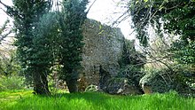
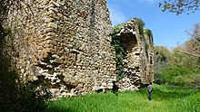
- 1 Anastasiopolis (Peritheorion (Greek: Αναστασιούπολις - Περιθεώριον)). Byzantine archaeological site with a special atmosphere on Lake Vistoni, not far from Porto Lagos. Anastasiopolis was founded as a military and trading point on the Via Egnatia and probably got its name from Emperor Anastasius (491-518 AD) who expanded and rebuilt the previously existing Roman station Stabulo Diomedis. It was located on the north shore of Vistonis Lake (between Xanthi and Komotini) with a major port with access across the lake to the sea. Because of the silting down by the nearby river, the ruined city is now some distance from the lake. The city was destroyed in the early 13th century, but later rebuilt under Andronikos III (1328-1341). Most surviving remains date from this phase, although earlier phases are relatively easy to spot. The Via Egnatia had at that time significantly lost importance as a trade route in favor of maritime trade (especially by the northern Italian cities, such as Venice). As a result, many places along the Via Egnatia were deprived of their economic base and their decline was unstoppable. Since no archaeological dig was carried out, the city is in a completely overgrown state, but this has a special charm, so it is definitely worth a visit, if you are traveling in the area. It was on the north shore of Vistonis Lake (between Xanthi and Komotini) with a major port with access across the lake to the sea. The location on both the road and the harbour made the city one of the most important stations on the Via Egnatia. Because of the silting up by the nearby river, the ruined city is now some distance from the lake. This led to a great loss of meaning and economic decline. The city was destroyed in the early 13th century, but later rebuilt under Andronikos III (1328-1341). Most surviving remains date from this phase, although earlier phases are relatively easy to recognize. The Via Egnatia at that time had significantly lost importance as a trade route in favor of maritime trade (especially by the northern Italian cities, such as Venice). Thus, many places along the Via Egnatia were deprived of the economic basis and the decline unstoppable. Since no archaeological excavations have been carried out, the city is in a completely overgrown state, but this has a special charm, so it is definitely worth a visit. It is a very photogenic "lost place". From the entrance gate, follow the dirt road that leads as a circular path along most of the ruins. There are no signs explaining the ivy overgrown ruins. Especially this combination of interesting ruins and the wild nature make the visit worthwhile.
- 2 Aqueduct. The remains of the former Aqueduct are still visible north of the city on the mountainside. This was the end of a 2.5 km long double wall, which ran from the fortress walls to the hills north. The free passage of the Egnatia was sealed off and thus controlled by the city. Within the double wall ran a line to supply the city with drinking water. You can still see the course in Goggle Earth today.
- 3 Medieval bridge in Polyanthos. The bridge dates to 17th-18th century and despite heavy damage is still impressive and worth seeing, if you're traveling in the area.The worth seeing bridge over the river Kompsatos is a historic medieval stone arched bridge. The two large bridge arches have a width of 21.8 and 17 m. The height of the arch is 12 m. The western of the original three arches has collapsed.
- 4 Fanari. Small tourist town with beautiful beaches and good harbour also for larger sailboats.
- 5 Loutra Potamis. Thermal bath with healing effect
- 6 Lake Vistonida.
- 7 Porto Lagos. About 30 km east of Xanthi lie the well-known monasteries of Porto Lagos worth seeing on islands in the lagoon. These are among the "must see" attractions in the harbour village.
- 8 Castle ruin Poroi. from the 9th to 14th century, which is also worth a visit.
Do
[edit]Buy
[edit]Eat
[edit]In the surrounding villages you will find restaurants as well as fast food especially in Iasmos village. But it is recommended to drive to the coastal villages Fanari or Porto Lagos (see Xanthi) because of the more beautiful environment.
- 1 To Perasma, Iroon 7-82, Iasmos, ☏ +30 690 877 1375.
- 2 Valedino Pizza, Ethinki Odos Komotinis-Xanthis 12, Iasmos.
- 3 fast food, Amaxades, ☏ +30 693 499 0876.
Drink
[edit]In each village there are kafeneios (simple traditional cafes) where mainly the farmers of the respective village spend their time. As the villages have a high percentage of Muslim population, as a tourist you should not go there in mismatched clothing. Iasmos, as a bigger place, has several modern cafes, which you can easily visit as a tourist.
Sleep
[edit]Around Natural Reserve Area of Lake Vistonis the best places to sleep are in the village Fanari or Porto Lagos. In the immediate vicinity of the lake there are many mosquitos, which can make the stay uncomfortable.
- 1 Petrinos Lofos.
- 2 [dead link] Porto Vistonis, Porto Lagos, Lagos, Xanthi.
- 3 Fanari Hotel.
Stay safe
[edit]- Because of the completely natural, jungle-like vegetation you should explore the area with suitable high shoes and tight clothing, also as protection against snakes.
- Sufficient protection against mosquitoes is required.
Connect
[edit]- Most cafés in Vistonida have free WiFi
Go next
[edit]| Routes through Vistonida |
| Kavala ← Xanthi ← | W |
→ Komotini → Alexandroupolis |


