The dive site Rachel's Reef is an offshore, rocky reef in the Karbonkelberg marine reserve area on the Cape Peninsula, near Hout Bay, a suburb of Cape Town in the Western Cape province of South Africa.
Understand
[edit]

This is a pleasant little pinnacle with extensive deeper surrounding reef.
Position
[edit]- 1 Rachel's Reef: S34°01.431' E018°18.151' — (pinnacle), a moderate distance offshore from Oude Schip headland, on the north side of Leeugat Bay, known locally as Maori Bay for the famous shipwreck.
Reef dive. Boat access only. Depth between about 3 and 21 m.
This site is in the Table Mountain National Park Marine Protected Area since 2004. A permit is required. The site is within the Karbonkelberg restricted area.
Name
[edit]The site is named after a local diver who was on the first dive at the site, and emigrated soon afterwards.
Depth
[edit]Maximum depth in the immediate vicinity is about 21 m, and the top of the pinnacle is at about 3 m. Average depth of a dive is likely to be about 18 m.
Visibility
[edit]Visibility is likely to be similar to the other offshore reefs of this part of the Cape Peninsula western seaboard. It may be very good for the region - between 10 and 20 m after a strong south-easterly wind, but this does not usually last long, particularly in summer.
Topography
[edit]The pinnacle is a massive but fairly compact outcrop of granite corestone, surrounded by high profile deeper reef.
Geology: Granite of the Pre-Cambrian Peninsula pluton.
Conditions
[edit]The site is exposed to westerly wind and waves, so should be dived in calm or south-easterly winds, when the prevailing south-westerly swell is moderate to low. The site is reasonably protected from south-easterly wind chop, but if a really strong south-easter develops then it would be prudent to dive one of the more sheltered inshore sites nearby. The site is usually at it's best in summer but there are also occasional opportunities at other times of the year. This is an area which sometimes has upwellings, caused by south easterly winds, resulting in cold clear conditions, until the sunshine gets the phytoplankton blooming and the visibility can reduce drastically over the course of a day, particularly in summer.
Get in
[edit][add listing]This site is only dived from a boat, as it is dangerously far offshore and there is no road access to the adjacent shore.
The site is about 8.5km from the Hout Bay harbour slipway
See
[edit][add listing]Marine life
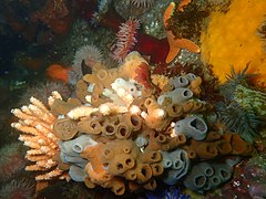
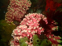
[edit][add listing]Colourful sponges, noble corals, sea anemones, basket stars, brittlestars and other starfish on the steep rock faces, Heavy growth of kelp in the shallower regions and smaller seaweeds on the top of the reef at middle depths, and sea urchins on the deeper reef top surfaces. Small shoals of hottentot seabream.
- Red seaweeds
- Sponges and cnidarians
- Sponge and bryozoans
- Noble coral
- Sea anemones
Photography
[edit][add listing]Theere are lots of fairly small, colourful invertebrates, so macro and wide angle lenses will be most versatile most of the time. On a really good day natural light will be sufficient, but much of the site is deep enough that there will not be much red left in the ambient light, even on a good day, so lighting will be needed to restore colour.
Suggested routes
[edit][add listing]There are no specific routes to recommend. Start deep and work up the reef, so you can do your safety stop with something to look at if the swell is low enough that the surge is not too strong. There are small caves and swim-throughs reported from the south-west part of the reef, at about 20 m depth, but their position is not known.
Stay safe
[edit]Hazards
[edit]No site-specific hazards have been reported. The water will be cold, and may be quite choppy, so it is worth carrying a DSMB and reel to alert the boat of your position if you surface away from the shot-line.
Skills
[edit]No special skills required, though it is useful to be able to deploy a DSMB. The site is suitable for fairly fit entry level divers.
Equipment
[edit]A dry-suit is recommended, as the water temperature can be as low as 8°C, and seldom above 12°C. Nitrox can extend your dive time considerably at this depth range if you can handle the temperature and your cylinder is big enough. Local divers favour EAN 32% and 12 to 15 litre cylinders with a dry suit.
Nearby
[edit]- 1 Logies Bay
- 2 MV Romelia
- 3 Steps
- 4 MV Harvest Capella
- 5 Humpback Ridge
- 6 Wilhelm's Wall
- 7 Die Middelmas
- 8 Twin Towers
- 9 MV Keryavor and the Jo May
- 10 SS Maori
- 11 SAS Gelderland
- 12 SS Oakburn / MV Bos 400
- 13 Die Perd
- 14 Kanobi’s Wall
- 15 SURG Pinnacles
- 16 Star Wall
- 17 Sunfish Pinnacle
Back to the list of dive sites in the Oude Schip and Leeugat area
Other regional dive sites:
- Dive sites of the Atlantic coast of the Cape Peninsula
- Dive sites of the False Bay coast of the Cape Peninsula
- Dive sites of False Bay Offshore
- Dive sites of the Eastern False Bay coast
- Fresh water dive sites of the Cape Town Metropolitan Area


