Southern Iraq stretches south of the Baghdad Belts of Iraq to Kuwait. It is also referred to as Lower Mesopotamia (Mesopotamia meaning the Land between the Rivers – the Euphrates and Tigris) or the Cradle of Civilization. The largest religious group in the area is Shia Islam.
Cities
[edit]Other destinations
[edit]
- 1 Babylon — A World heritage-listed ruin one of the most prominent cities of Ancient Mesopotamia.
- 2 Uruk — An ancient city of Sumer
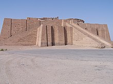
- 3 Ur — Important city during the Sumerian era, includes the partly restored Great Ziggurat
- 4 Mesopotamian Marshes — Wetland area with huge cultural and natural importance. A World heritage site.
- 5 Hawizeh Marshes — Another large complex of marshes that straddle the Iran–Iraq border.
Understand
[edit]The entirety of Karbala Province is located here, and is notable as the place of Martyr Imam Husain, where he fought war with Yazid, then Emperor or caliph of muslims, who had support of sunnis, and was thus proclaimed Caliph. The place has the tomb Imam as well as his armies Commander-in-chief and brother Abbas Allambardar. The Imam Husain's army had 96 warriors including women's and children were called Ahlebait. The total deaths in Ahlebait was 72. The place has the tomb of all the martyrs. It is considered a sacred place for Shi'a Muslims.
Get in
[edit]By plane
[edit]The main international gateway is Basra. A smaller airport exists in Najaf while the airport in Karbala is under construction as of late 2020.
By train
[edit]There are overnight trains from Baghdad to Basra, calling in many cities in the region on its way. Additionally there are seasonal trains to Karbala from both Baghdad and Basra, mostly around religious festivals. While there are no international trains into Iraq, the border city of Khorramshahr, in Iran sees daily trains from Tehran. It's possible to continue the last few kilometers by taxi, bus or ferry to Basra.
By car
[edit]Driving is perhaps the most common way of getting around. Freeway 1 runs in a north-south direction, connecting Basra with Baghdad. The road is generally in good condition, but traffic can be bad. Highway 9 connects Najaf, Karbala and Baghdad. Smaller roads are generally in worse condition.
The borders are open from both Iran, Kuwait and Saudi Arabia but expect hassle and long ques at all crossings.
By ferry
[edit]A river ferry is available from Khorramshahr, across the border in Iran, to Basra. The journey takes just 45 minutes and there are multiple sailings each week.
Get around
[edit]See
[edit]
Southern Iraq is home to a mixed world heritage site, The Ahwar of Southern Iraq: Refuge of Biodiversity and the Relict Landscape of the Mesopotamian Cities, comprising four marshland areas and three Sumerian archaeological sites:
- Huwaizah Marshes
- Central Marshes
- East Hammar Marshes
- West Hammar Marshes
- Uruk Archaeological City
- Ur Archaeological City
- Tell Eridu Archaeological Site
Do
[edit]Eat
[edit]Drink
[edit]Stay safe
[edit]Southern Iraq is much safer than the rest of Iraq, but even here it is important to remain vigilant at all times and ensure you are well protected.


