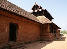
Kannapuram is a small town in Kannur District, Malabar region, Kerala, India.
Understand
[edit]Kannapuram is a sort of launching pad for visiting the nearby towns of Mattool, Cherukunnu, Ezhom, Muttam, Mangattuparamba, Dharmasala, Taliparamba and Pariyaram because railway station is available only in Kannapuram. The population of the town is 18,000.
Get in
[edit]There are major railway stations at Kannapuram, Kannur, Payyanur and Pazhayangadi. Buses are available from Payyanur, Taliparamba, Kannur and Payyannur. The nearest airports are at Mangalore and Kozhikode.

Get around
[edit]Autorikshaws are very cheap at ₹15 per km. Buses are even cheaper but you have to board them from the starting points to ensure a seat. Air Conditioned taxis are available for ₹1,000 per day. Walking is pleasant in the village footpaths, but paved roads are occupied by incredible number of noisy motorcycles.
See
[edit]- 1,000 coconut island (Ayiram Thengu Dweep) (Mungam).
- Ancient Catholic Church, Thavam (7 km).
- 1 Ancient St. Martin de Pores Hospital (Mission Hospital), Cherukunnu (3 km). Beautiful building
- China Clay Mines, Mottammal Hills (15 km).
- Eco Tourism Centre, Vellikkeel Park.
- Eco Tourism facility, Vellikkeel park (8 km).
- Karakkunnu Hills, Keezhara.
- Kayatteel Ferry (4 km).
- Madayi Mosque, Payangadi (9 km). One of the oldest mosques in India, built around AD.740
- Madayi Rock, 365 hectres (Madayippara), Payangadi (11 km). A very spacious hillock with several educational institution located on top of it. Famous Madayi Kavu Temple is situated here. There is a Jew' Pond on the rock. There is a travelers bungalow built by the British in 1793 on the eastern side of it.
- Muchilott Bhagavathy Temple, Kannapuram (Theyyam Dance is performed here).
- 2 Oliyankara Juma Masjid, Mattool road (6 km).
- Thaneerpara hills, Keezhara Road.
Temples
[edit]
Do
[edit]- Birdwatching @ Madayi Rocks, Madayippara (Near Payangadi).
- Enjoy the river views (from Padiyil, Kavinisseri and Kunnanangadu hills.).
- Mattoo Estuary, Mattool South (5 km). Spectacular silent beaches. You must devout a lot of time as the area is quite big. Make sure you look at maps.google.com to familiarize this place before going. Once the map is with you, the place is little more than spectacular.
- Paddy Field walk @ Ezhom, Payangadi - Taliparamba road (13 km). An expanse of paddy fields can be enjoyed in the middle of the Ezhom village. You have to hurry, they are planning to build an airport in that place destroying all the landscape.
- Walk in the Mangrove forest, Payangadi to Muttukandu Road. A refreshing walk in the 17 km long mangrove forest founded by Late. Kallan Pokkudan
Eat
[edit]
- Jayanthi Hotel, Mattool Road.
- 1 Kairaly Hotel (Kairali Hotel), Cherukunnu.
- Narayanans Hotel, Annapoorna Temple Road.
- 2 Super Restaurant, Kannapuram Bridge.
- Pams Bakes, Opposite Railway Station, ☏ +91 9562994994. Popular for their Shawarmas.
Drink
[edit]Sleep
[edit]- Tamarind Hotel, Parassinikkadavu, ☏ +91 497 278 0220.
- Uthradam Hill Resort, Ezhimala, ☏ +91 94465 43353.
Connect
[edit]Go next
[edit]- Iritty Hills, 50 km
- Kannur city, 14 km
- Parassinikkadavu, 13 km
- Payyanur, 23 km
- Taliparamba, 15 km
- Thalassery city, 35 km


