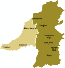
Mid Wales (Welsh: Canolbarth Cymru) is in the United Kingdom.
Counties

| Ceredigion Cardigan Bay, and the Cambrian Mountains. |
| Powys A mountainous area with scattered small towns. Consists of the historic counties of Brecknockshire, Montgomeryshire and Radnorshire |
Towns
- 1 Aberystwyth (Ceredigion)
- 2 Brecon (Welsh: Aberhonddu) (Powys)
- 3 Builth Wells (Welsh: Llanfair ym Muallt) (Powys)
- 4 Cardigan (Welsh: Aberteifi) (Ceredigion)
- 5 Hay-on-Wye (Welsh: Y Gelli Gandryl) (Powys)
- 6 Lampeter (Welsh: Llanbedr Pont Steffan or Llambed) (Ceredigion)
- 7 Llanidloes (Powys)
- 8 Llanwrtyd Wells (Powys)
- 9 Machynlleth (Powys)
Other destinations
- 1 Brecon Beacons National Park (Welsh: Bannau Brycheiniog)
Understand
Mid Wales is the sparsely-populated heart of Wales, covering more than a third of the total area of the country but containing only around 1/15 of its population, with the university town of Aberystwyth being one of only few settlements of any significant size. It stretches from the fringes of Snowdonia in the north to the edge of industrial South Wales, and from the English border to the Irish Sea.
Much of the region consists of the remote upland area of the Cambrian Mountains. They are not high by UK or international standards - the highest point is Pumlumon Fawr, at 752 metres or 2,467 feet. But they are wild and remote, with only a few small villages and isolated farms, and crossed by only a handful of roads; the land is largely useful only for sheep-farming and forestry. Several of the valleys were also flooded in the 1950s and 1960s to create reservoirs mainly serving England, which proved controversial at the time. The mountains also act as a barrier between the more English-speaking county of Powys in the east and the predominantly Welsh-speaking county of Ceredigion to the West. The areas towards the English border and are lower-lying, more fertile and more heavily populated, particularly in the valleys of the rivers Severn, Wye and Usk, all of which rise in the mountains. While the scenery of mid Wales may not match the rugged grandeur of Snowdonia, it has an appeal of its own: softer and greener, yet much emptier and less given over to tourism.
Talk
As elsewhere in Wales, English is universally understood. Welsh is, though, widely spoken in western Powys and in Ceredigion, and predominates in many parts of the latter. Visitors will not be expected to speak Welsh, but respect for the language and at least an attempt to pronounce place-names and so on correctly goes a long way with Welsh-speakers.
Get in
By car
The main routes into mid Wales are the A470 (from north and south Wales), the A483 (from Swansea and Wrexham), and the A40, A44 and A458 (from across the border in England). All are single-carriageway roads: one demonstration of the remoteness of mid Wales is that there are no motorways or dual carriageways in the area at all apart from a short bypass around Brecon.
By train
Arriva Trains Wales operates the Cambrian Line from Shrewsbury (with some services starting from Birmingham) to Aberystwyth, via the Severn Valley towns of Welshpool, Newtown and Caersws. Arriva Trains also run the famous Heart of Wales Line from Swansea to Shrewsbury. This service takes almost 4 hours to make the 120-mile journey through mid Wales due to the many gradients and turns. It is popular with tourists but also provides an essential service to rural communities along the route.
By plane
There are no airports or air services in mid Wales. The nearest airports are at Cardiff and Birmingham.
Get around
See
- Strata Florida Abbey near Pontrhydfendigaid
- Devil's Bridge waterfall
- Ynyslas dunes near Borth
- Centre for Alternative Technology Machynlleth
- Powis Castle and Garden, near Welshpool
Do
Work on organic farms - Wales is home to many communes and organic farms, and WWOOF can arrange for volunteers to work for free at some of these place in exchange for room and board. It is an excellent way to experience life in the Welsh countryside, make friends and, at the same time, learn a little about organic farming.
Go next
`

