Jump to content

Download GPX file for this article
23.33333386.366667Full screen dynamic map
From Wikivoyage
This is an old revision of this page, as edited by Zcarstvnz (talk | contribs) at 15:19, 22 December 2023 (Added geo coordinates and zoom level.).
(diff) ← Older revision | Latest revision (diff) | Newer revision → (diff)

Asia > South Asia > India > Eastern India > West Bengal > Bankura and Purulia

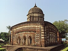
Radhashyam Temple, Bishnupur

Bankura and Purulia are two westernmost districts of West Bengal, lying on the Chota Nagpur Plateau.

Cities

[edit]
Map
Map of Bankura and Purulia

  • 1 Amarkanan Koro Hill and Gangdua Dam
  • 2 Bankura headquarters of Bankura district
  • 4 Bishnupur (Vishnupur) home to numerous terracotta temples
  • 5 Jayrambati birthplace of Sarada Devi, wife of Sri Ramakrishna
  • 6 Mukutmanipur a tourist spot with the dam across the river and the hilly landscape
  • 7 Purulia headquarters of Purulia district

Other destinations

[edit]
  • 2 Biharinath the tallest hill in the region
  • 3 Panchet Dam Panchet Dam on Wikipedia a popular picnic spot
  • 4 Susunia archaeological and rock climbing centre


Understand

[edit]
Ajodhya Hills

Get in

[edit]

Get around

[edit]

See and do

[edit]

Major landmarks include the terracotta temples in Bishnupur. Hills like Ajodhya, Biharinath, Joychandi and Susunia are also notable attractions and you can also trek these hills.

Eat

[edit]

Drink

[edit]

Stay safe

[edit]

Go next

[edit]
This region travel guide to Bankura and Purulia is an outline and may need more content. It has a template, but there is not enough information present. If there are Cities and Other destinations listed, they may not all be at usable status or there may not be a valid regional structure and a "Get in" section describing all of the typical ways to get here. Please plunge forward and help it grow!