Jump to content

Download GPX file for this article
23.33333386.366667Full screen dynamic map
From Wikivoyage

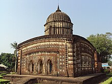
Radhashyam Temple, Bishnupur

Bankura and Purulia are two westernmost districts of West Bengal, lying on the Chota Nagpur Plateau.

Cities

[edit]
Map
Map of Bankura and Purulia

  • 1 Amarkanan Koro Hill and Gangdua Dam
  • 2 Bankura headquarters of Bankura district
  • 4 Bishnupur (Vishnupur) home to numerous terracotta temples
  • 5 Jayrambati birthplace of Sarada Devi, wife of Sri Ramakrishna
  • 6 Mukutmanipur a tourist spot with the dam across the river and the hilly landscape
  • 7 Purulia headquarters of Purulia district

Other destinations

[edit]
  • 2 Biharinath the tallest hill in the region
  • 3 Panchet Dam Panchet Dam on Wikipedia a popular picnic spot
  • 4 Susunia archaeological and rock climbing centre


Understand

[edit]
Ajodhya Hills

Get in

[edit]

Get around

[edit]

See and do

[edit]

Major landmarks include the terracotta temples in Bishnupur. Hills like Ajodhya, Biharinath, Joychandi and Susunia are also notable attractions and you can also trek these hills.

Eat

[edit]

Drink

[edit]

Stay safe

[edit]

Go next

[edit]
This region travel guide to Bankura and Purulia is an outline and may need more content. It has a template, but there is not enough information present. If there are Cities and Other destinations listed, they may not all be at usable status or there may not be a valid regional structure and a "Get in" section describing all of the typical ways to get here. Please plunge forward and help it grow!